Doppler storm radar - eMap HDF
広告が表示されますアプリ内購入あり
4.5star
5620 件のレビュー
10万+
ダウンロード

全ユーザー対象
info


このアプリについて
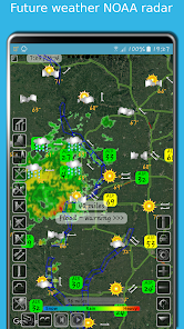
eMap HDF is a high-resolution predictive NOAA Doppler storm radar with a weather map.
The weather app has the next layers provided by the National Weather Service (NWS) & NOAA:
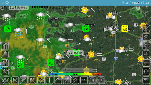
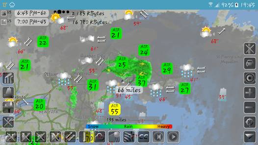
- Snow and rain radar
- Severe weather alerts, tornado tracker, heavy rain and wind alerts
- Lightning strike map
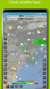
- Cloud satellite layer
Worldwide layers:
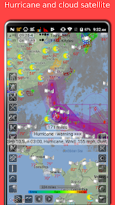
- Typhoon (tropical storm, cyclone) and hurricane tracker provided by GDACS
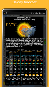
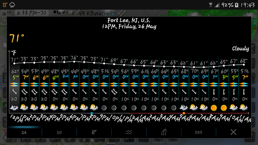
- Accurate weather forecast for 10 days
- Hourly weather forecast for 24 hours
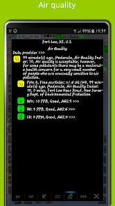
- Air quality and air pollution
- Earthquake map
- Temperature map
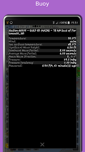
- Sea temperature based on measurements from buoys and satellites
- Tide charts
- Local time in each city
- Number of residents in cities
- Road traffic
- Buoys
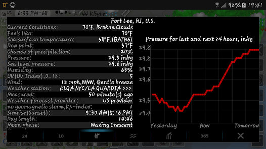
- Dew point
- Humidity
- Wind map
The storm radar app calculates a one-hour prediction of rain and snow in five-minute frames. NOAA radar has a six-hour weather radar history.
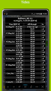
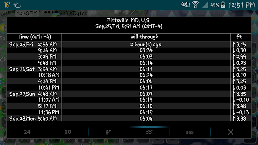
Tide times are for over 10,000 tidal stations in the US, UK, Canada, etc. with forecasts for several months. The app follows the current location and shows the tides near me.
The earthquake app includes earthquakes filtered by magnitude and depth. Earthquake tracker data is provided by the USGS.
The distance measurement tool shows the distance between two points in miles and kilometres.
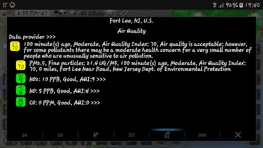
The air quality app includes concentrations of ozone (O3), fine (PM25) and coarse (PM10), particulate matter, dioxide (NO2) and nitrogen oxide (NO), carbon monoxide (CO), etc. from various sources: AirNow, Copernicus, ECMWF, etc.
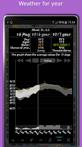
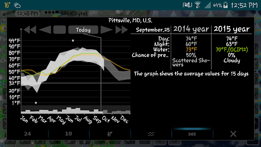
With the Doppler radar app, you can long-click on any location on the map and see the weather at that location with the archive for the last few years. The archive includes sea and air temperature, precipitation and cloud cover. Travel weather helps you choose the right time and place for your upcoming trip and compare temperatures and precipitation between this year and past years.
If you click on the "CC" button and toggle to "10" or "24", you can view a 10-day or 24-hour forecast directly on the map.
eMap HDF shows road traffic. The forecast includes not only temperature and precipitation, but also humidity, wind speed and direction, dew point, visibility on the roads feels like temperature.
As the data published in eMap HDF is not subject to use on the voyage, please do not use it for navigation.
The weather app has the next layers provided by the National Weather Service (NWS) & NOAA:
- Snow and rain radar
- Severe weather alerts, tornado tracker, heavy rain and wind alerts
- Lightning strike map
- Cloud satellite layer
Worldwide layers:
- Typhoon (tropical storm, cyclone) and hurricane tracker provided by GDACS
- Accurate weather forecast for 10 days
- Hourly weather forecast for 24 hours
- Air quality and air pollution
- Earthquake map
- Temperature map
- Sea temperature based on measurements from buoys and satellites
- Tide charts
- Local time in each city
- Number of residents in cities
- Road traffic
- Buoys
- Dew point
- Humidity
- Wind map
The storm radar app calculates a one-hour prediction of rain and snow in five-minute frames. NOAA radar has a six-hour weather radar history.
Tide times are for over 10,000 tidal stations in the US, UK, Canada, etc. with forecasts for several months. The app follows the current location and shows the tides near me.
The earthquake app includes earthquakes filtered by magnitude and depth. Earthquake tracker data is provided by the USGS.
The distance measurement tool shows the distance between two points in miles and kilometres.
The air quality app includes concentrations of ozone (O3), fine (PM25) and coarse (PM10), particulate matter, dioxide (NO2) and nitrogen oxide (NO), carbon monoxide (CO), etc. from various sources: AirNow, Copernicus, ECMWF, etc.
With the Doppler radar app, you can long-click on any location on the map and see the weather at that location with the archive for the last few years. The archive includes sea and air temperature, precipitation and cloud cover. Travel weather helps you choose the right time and place for your upcoming trip and compare temperatures and precipitation between this year and past years.
If you click on the "CC" button and toggle to "10" or "24", you can view a 10-day or 24-hour forecast directly on the map.
eMap HDF shows road traffic. The forecast includes not only temperature and precipitation, but also humidity, wind speed and direction, dew point, visibility on the roads feels like temperature.
As the data published in eMap HDF is not subject to use on the voyage, please do not use it for navigation.
最終更新日
データの安全は、デベロッパーによるユーザーデータの収集、共有方法を理解することから始まります。データのプライバシーとセキュリティの方針は、アプリの使用方法、ユーザーの年齢やお住まいの地域によって異なることがあります。この情報はデベロッパーから提供されたもので、更新されることがあります。

このアプリはサードパーティと以下の種類のデータを共有することがあります
デバイスまたはその他の ID

データは収集されません
詳しくは、デベロッパーが収集を申告する方法についての説明をご覧ください

データは送信中に暗号化されます

データを削除できません
評価とレビュー
4.5
4900 件のレビュー

satooo kyoodai
- 不適切として報告
- レビュー履歴を表示
2022年6月3日
これ全然だめだめだめ!! 激しい雷が真上から 聞こえ 稲光が連続して光っていて大雨が降ってるというのに まったく それが表示されない。 ひたすら 曇りマークだけが 表示されたまま だ。 まだ Yahoo 天気予報のがマシ
3 人のユーザーが、このレビューが役立ったと評価しました
Elecont software
2022年6月4日
私たちのアプリと間違った予測についてのあなたのメッセージを選んでくれてありがとう。 「CC」ボタンをクリックして「10」または「24」に切り替えると、10日または24時間の天気予報を地図上に直接表示できます。

IoT londsdale GsM unlocked network
- 不適切として報告
2021年9月7日
🎳
3 人のユーザーが、このレビューが役立ったと評価しました
Elecont software
2021年9月8日
私たちのアプリをお選びいただきありがとうございます。見逃した場所を書いてください。数時間以内に追加します。

Googleユーザー
- 不適切として報告
2015年10月3日
UIが面白い
10 人のユーザーが、このレビューが役立ったと評価しました
最新情報
名前で場所を検索
いくつかのエラーが修正され、ユーザー インターフェイスが改善されました
いくつかのエラーが修正され、ユーザー インターフェイスが改善されました


