New Zealand Topo Maps
Contains adsIn-app purchases
4.6star
2.93K reviews
100K+
Downloads

Everyone
info


About this app
Easy to use outdoor navigation app with most recent topographic maps of New Zealand, Cook Islands and Tokelau.
This app gives you similar mapping options as you might know from Garmin or Magellan GPS handhelds.
Main features for outdoor-navigation:
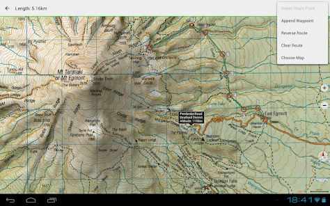
• Create and edit Waypoints
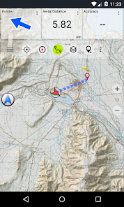
• GoTo-Waypoint-Navigation
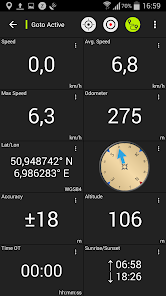
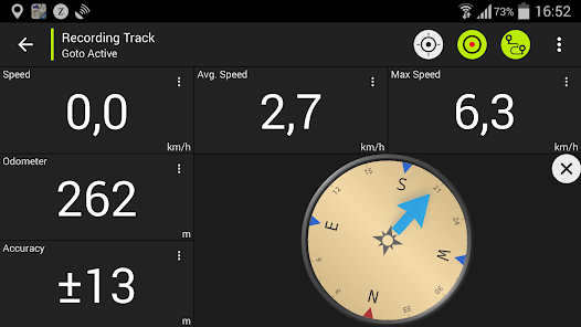
• Track Recording (with speed, elevation and accuracy profile)
• Tripmaster with fields for odometer, average speed, bearing, elevation, etc.
• GPX-Import / Export, KML-Export
• Search (placenames, POIs, streets)
• Customizable datafields in Map View and Tripmaster (e.g. Speed, Distance, Compass, ...)
• Share Waypoints, Tracks or Routes (via eMail, Facebook, ..)
• Use Coordinates in UTM, WGS84 or MGRS
• and many more ...
Available base map layers:
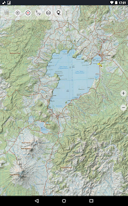
• Topomaps New Zealand (seamless coverage at scales 1:250.000 and 1:50.000)
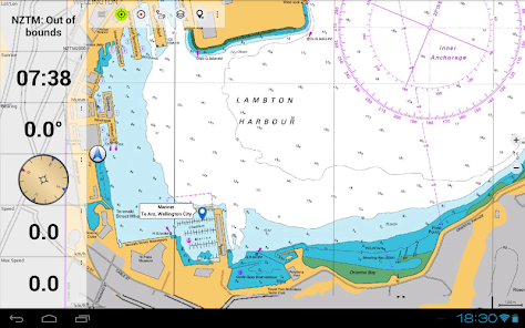
• NZMariner (RNC Nautical Charts)
• LINZ Aerial Imagery
• Google Maps (Satellite images, Road- and Terrain-Map)
• Open Street Maps
• Bing Maps
• ESRI Maps
Overlay layers:
• Public Conservation Areas
• Open Hunting Areas
• DOC Camp Sites
• DOC Freedom Camping Restrictions
• DOC Huts
• DOC TRacks
• Taupo Trout Fishing District
• Hillshading
Use this navigation app for outdoor activities like hiking, biking, camping, climbing, riding, skiing, canoeing or offroad 4WD tours.
Preload FREE map data for areas without cell service. (Pro version only)
LIMITATIONS OF THE FREE VERSION:
• Ads
• Max. 3 Waypoints
• Max. 3 Tracks
• No Routes
• No import of waypoints and tracks
• No Bulkdownload
• No Local City DB (Offline Search)
The topographic maps were created by Land Information New Zealand (LINZ).
Topo50 is the official topographic map series used by New Zealand emergency services.
How topographic information is used
Defence planning: New Zealand's defence forces use topographic information for planning military exercises and swapping information with international partners.
Location and routing: Search and Rescue, defence, ambulance, fire service, police and civil defence agencies use topographic information in a wide range of planning and operational situations, from natural disasters to community policing. Usage may involve mobile/field and control room situations, and the combination of topographic information with other data.
Land management: Topographic information is used by local government for regional planning and operations, and by power, gas and telecommunications companies.
In addition, LINZ maps are used for a great variety of purposes by businesses and government departments such as the Department of Conservation, and by recreational users such as trampers and tourists.
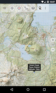
All topographic maps have additional labels for better readability at higher zoom scales. Maps are rendered with Atlogis® hillshading to enhance topography.
Topo Map Coverage:
New Zealand and Islands (Antipodes, Auckland, Bounty, Campbell, Chatham, Kermadec, Raoul, Snares and Stewart Islands) at scale 1:50.000 and 1:250.000
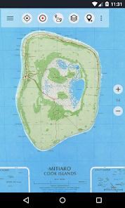
Cook Islands (Aitutaki, Atiu, Mangaia, Manihiki, Mauke, Mitiaro, Palmerston, Penrhyn, Pukapuka, Rakahanga, Rarotonga, Suwarrow, Takute) at scale 1:25.000
Tokelau Islands (Atafu, Nukunonu, Fakaofo) at scale 1:25.000
Please send comments and feature requests to nzmaps@atlogis.com
This app gives you similar mapping options as you might know from Garmin or Magellan GPS handhelds.
Main features for outdoor-navigation:
• Create and edit Waypoints
• GoTo-Waypoint-Navigation
• Track Recording (with speed, elevation and accuracy profile)
• Tripmaster with fields for odometer, average speed, bearing, elevation, etc.
• GPX-Import / Export, KML-Export
• Search (placenames, POIs, streets)
• Customizable datafields in Map View and Tripmaster (e.g. Speed, Distance, Compass, ...)
• Share Waypoints, Tracks or Routes (via eMail, Facebook, ..)
• Use Coordinates in UTM, WGS84 or MGRS
• and many more ...
Available base map layers:
• Topomaps New Zealand (seamless coverage at scales 1:250.000 and 1:50.000)
• NZMariner (RNC Nautical Charts)
• LINZ Aerial Imagery
• Google Maps (Satellite images, Road- and Terrain-Map)
• Open Street Maps
• Bing Maps
• ESRI Maps
Overlay layers:
• Public Conservation Areas
• Open Hunting Areas
• DOC Camp Sites
• DOC Freedom Camping Restrictions
• DOC Huts
• DOC TRacks
• Taupo Trout Fishing District
• Hillshading
Use this navigation app for outdoor activities like hiking, biking, camping, climbing, riding, skiing, canoeing or offroad 4WD tours.
Preload FREE map data for areas without cell service. (Pro version only)
LIMITATIONS OF THE FREE VERSION:
• Ads
• Max. 3 Waypoints
• Max. 3 Tracks
• No Routes
• No import of waypoints and tracks
• No Bulkdownload
• No Local City DB (Offline Search)
The topographic maps were created by Land Information New Zealand (LINZ).
Topo50 is the official topographic map series used by New Zealand emergency services.
How topographic information is used
Defence planning: New Zealand's defence forces use topographic information for planning military exercises and swapping information with international partners.
Location and routing: Search and Rescue, defence, ambulance, fire service, police and civil defence agencies use topographic information in a wide range of planning and operational situations, from natural disasters to community policing. Usage may involve mobile/field and control room situations, and the combination of topographic information with other data.
Land management: Topographic information is used by local government for regional planning and operations, and by power, gas and telecommunications companies.
In addition, LINZ maps are used for a great variety of purposes by businesses and government departments such as the Department of Conservation, and by recreational users such as trampers and tourists.
All topographic maps have additional labels for better readability at higher zoom scales. Maps are rendered with Atlogis® hillshading to enhance topography.
Topo Map Coverage:
New Zealand and Islands (Antipodes, Auckland, Bounty, Campbell, Chatham, Kermadec, Raoul, Snares and Stewart Islands) at scale 1:50.000 and 1:250.000
Cook Islands (Aitutaki, Atiu, Mangaia, Manihiki, Mauke, Mitiaro, Palmerston, Penrhyn, Pukapuka, Rakahanga, Rarotonga, Suwarrow, Takute) at scale 1:25.000
Tokelau Islands (Atafu, Nukunonu, Fakaofo) at scale 1:25.000
Please send comments and feature requests to nzmaps@atlogis.com
Updated on
Safety starts with understanding how developers collect and share your data. Data privacy and security practices may vary based on your use, region, and age. The developer provided this information and may update it over time.

This app may share these data types with third parties
Personal info, App activity, and App info and performance

No data collected
Learn more about how developers declare collection

Data is encrypted in transit

You can request that data be deleted
Ratings and reviews
4.6
2.67K reviews

Andrew & Vi Cook
- Flag inappropriate
March 30, 2024
Slow to bring up map when it opens, difficult to bring across to new device if you change your phone, won't show some map overlays on my phone. BUT - the nav side of it is fantastic. Map detail, distance netween waypoints, direction info, all good points.
ATLOGIS Geoinformatics GmbH & Co. KG
March 30, 2024
Thanks for your Feedback. Please contact support@atlogis.com for assistance if problems with overlays and data migration occur

Daniel Sauer
- Flag inappropriate
- Show review history
April 4, 2024
Does what it says on the tin. Snappy and reliable offline map app. With this and a USB power bank, getting lost in the back country is a thing of the past.

Jasonw
- Flag inappropriate
- Show review history
March 10, 2024
WASTE OF MONEY!!!! I paid for the original version, then they tell me I have to pay a yearly subscription. Rip off dudes. And it struggles to load properly even with good reception!!! Topo 50 is way cheaper, and better. Plus it caches so you can use it in the Bush. NZ TOPO, biggest rip off!!
3 people found this review helpful
What's new
・Improvements & Fixes


