
C7 Lignum Urbem
4.6star
8 reviews
1K+
Downloads

Everyone
info
About this app
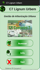
The C7 Lignum Urbem application aims to contribute in the management processes and management of trees in the context of an urban space, being structured by the following functions:
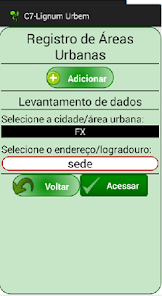
- Definition of Urban Area. (Cadastre Municipality, district, village, etc.) which are bound playgrounds / addresses. Primary Level
- Address Register. Urban public parks that have trees or to be subject to afforestation plans, and these playgrounds are registered with ties to an Urban Area.
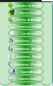
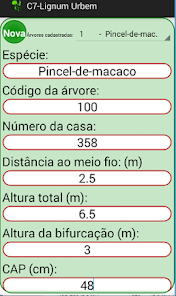
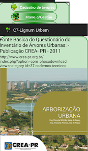
- Trees Registration. Function to record georeferenced urban trees located at a certain address / Exterior. The questionnaire for the data collection is based on a CREA-PR publishing in 2011, called Urban Forestry (http://www.crea-pr.org.br/index.php? Option = com_phocadownload view = category id = 37 : roll-technical). In the application database already in the register 1423 forest species according to the RNC (National Register of Cultivars - MAP), however the user can register new species in the database if necessary. There are about 30 information for the characterization of a tree in the database, covering dendrometric data, tree conditions in terms of health and vitality, management needs for pruning and records conflict (electricity, water network etc.) .
- Planting seedlings. Function to register new or replacement plantings and species in the street, with planting date data type and source of changes, etc.
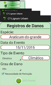
- Damage registration. Function to record damage in trees because of various events, such as weather, traffic accidents, vandalism, etc.
- Management and Management. Registration transactions, such as pruning, pest control, cleaning etc. Single per tree or public place.
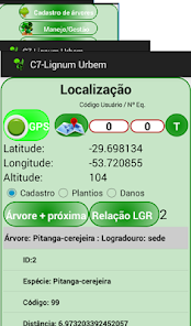
- Localization. Function that allows the identification "in loco" of trees registered in a public place from the device GPS use
- Spatial: All registered elements (trees, plantations and damage) can be viewed and edited identified and spatially in Google Maps.
- Dynamic reports with filters regarding the registration and management functions with option to save in PDF format.
- Database Export and registration data and operations in CSV files and send these files by e-mail in the application itself.
This is the first version of the application and are awaiting suggestions and criticism from users, in order to aperfeiçoarmos the same, thus meeting the expectations of these users forward their academic and professional needs ..
Access the tutorial video and handout Operating Guide www.crcampeiro.net the link Series: How to
- Definition of Urban Area. (Cadastre Municipality, district, village, etc.) which are bound playgrounds / addresses. Primary Level
- Address Register. Urban public parks that have trees or to be subject to afforestation plans, and these playgrounds are registered with ties to an Urban Area.
- Trees Registration. Function to record georeferenced urban trees located at a certain address / Exterior. The questionnaire for the data collection is based on a CREA-PR publishing in 2011, called Urban Forestry (http://www.crea-pr.org.br/index.php? Option = com_phocadownload view = category id = 37 : roll-technical). In the application database already in the register 1423 forest species according to the RNC (National Register of Cultivars - MAP), however the user can register new species in the database if necessary. There are about 30 information for the characterization of a tree in the database, covering dendrometric data, tree conditions in terms of health and vitality, management needs for pruning and records conflict (electricity, water network etc.) .
- Planting seedlings. Function to register new or replacement plantings and species in the street, with planting date data type and source of changes, etc.
- Damage registration. Function to record damage in trees because of various events, such as weather, traffic accidents, vandalism, etc.
- Management and Management. Registration transactions, such as pruning, pest control, cleaning etc. Single per tree or public place.
- Localization. Function that allows the identification "in loco" of trees registered in a public place from the device GPS use
- Spatial: All registered elements (trees, plantations and damage) can be viewed and edited identified and spatially in Google Maps.
- Dynamic reports with filters regarding the registration and management functions with option to save in PDF format.
- Database Export and registration data and operations in CSV files and send these files by e-mail in the application itself.
This is the first version of the application and are awaiting suggestions and criticism from users, in order to aperfeiçoarmos the same, thus meeting the expectations of these users forward their academic and professional needs ..
Access the tutorial video and handout Operating Guide www.crcampeiro.net the link Series: How to
Updated on
Data safety
Developers can show information here about how their app collects and uses your data. Learn more about data safety

No information available
Ratings and reviews
4.6
8 reviews


