
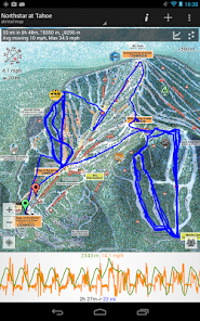
GPS on ski map
4.2star
1.24K reviews
100K+
Downloads

Everyone
info


About this app
Maprika is the best mapping solution for ski resorts, parks, and campuses.
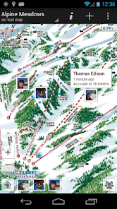
Maprika uses GPS to put a "You are here" sign on "paper" maps, just like the ones you get at ski resort ticket windows or park information booths.
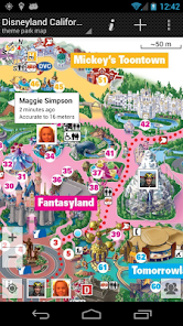
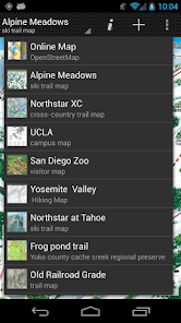
• Navigate on more than 15000 maps of ski resorts, hiking and biking trails, theme parks, and university campuses
• Maprika maps are saved to the phone's memory, allowing for use in out of service areas.
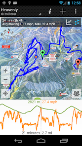
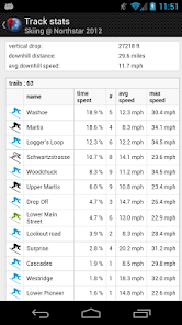
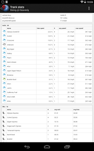
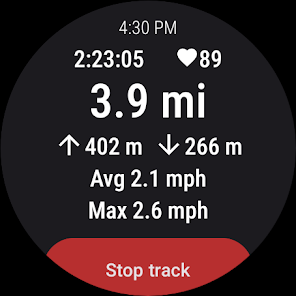
• Record GPS tracks and show them real-time; export tracks and view them on your computer; record GPS tracks on your Wear OS device
• Share your location with friends
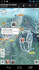
• Set meetings with your friends by pointing the place on a map
• Make your own maps and share them with the Maprika community
• See local weather, snow reports, and Twitter feeds for resort maps, find nearby attractions
Maprika uses GPS to put a "You are here" sign on "paper" maps, just like the ones you get at ski resort ticket windows or park information booths.
• Navigate on more than 15000 maps of ski resorts, hiking and biking trails, theme parks, and university campuses
• Maprika maps are saved to the phone's memory, allowing for use in out of service areas.
• Record GPS tracks and show them real-time; export tracks and view them on your computer; record GPS tracks on your Wear OS device
• Share your location with friends
• Set meetings with your friends by pointing the place on a map
• Make your own maps and share them with the Maprika community
• See local weather, snow reports, and Twitter feeds for resort maps, find nearby attractions
Updated on
Safety starts with understanding how developers collect and share your data. Data privacy and security practices may vary based on your use, region, and age. The developer provided this information and may update it over time.


Ratings and reviews
4.2
1.19K reviews

Helio Clemente
- Flag inappropriate
- Show review history
April 17, 2024
I've been using it for years for mountain biking. Love that you can either download crowd sourced maps or upload your own. Creating your own map from a park's trail map is extremely useful, especially for less-known trails. Love this app! Can't get lost when using it.

HydroStarr Gardens, llc
- Flag inappropriate
November 27, 2020
Tried several equine and non equine apps to document our rides. So far, this is the most reliable app. Documented trail path on map even without a cellular signal. What I especially like is the beacon arrow on the map that shows your current position on the trail...prevents you from getting lost on unmarked or poorly markes trails. App uses minimal power.
25 people found this review helpful

Ed M.
- Flag inappropriate
September 22, 2023
I've been using this app for years. It is awesome for both skiing and hiking. The ability to create your own downloaded map from any paper or map image is great. Depending on your level of tech saviness it takes a little to learn how to do. Once you learn it is very quick and easy. Tracking others while skiing is great. Highly recommend!
1 person found this review helpful
What's new
- record track on android watch
- get heart rate from android watch when recording track on phone, show it along the track
- add an option to resume last recorded track
- show track times in local time of track location
- get heart rate from android watch when recording track on phone, show it along the track
- add an option to resume last recorded track
- show track times in local time of track location