PRO CHARTS - Marine Navigation
In-app purchases
2.6star
21 reviews
1K+
Downloads

Everyone
info
About this app
MiraTrex PRO CHARTS™ is a powerful, yet easy-to-use marine navigation solution. PRO CHARTS™ includes high resolution NOAA charts and other nautical maps not included with a traditional chartplotter. Whether you’re a fisherman, weekend cruiser, sailor, jet-skier, or an offshore captain needing to find an exact location hundreds of miles offshore, PRO CHARTS™ will get you there and back home safely.
The free evaluation version displays standard satellite, road, and hybrid maps. An in-app subscription purchase of $2.99/mo or $29.99/yr includes nautical charts, navigational features, and frequent app upgrades.
Key Features:
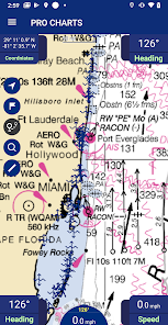
• High-resolution nautical chart coverage for all U.S. coastal areas, the Great Lakes, major U.S. river systems, and Brazil plus global high-level nautical charts. Charts are automatically updated every 7 days based on NOAA chart corrections.
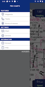
• Easy one-touch Waypoint and Route creation. Pre-plan your routes at home or create them at sea with equal ease. Just touch the screen to create new waypoints and routes.
• Find your friends on the water. With our new Buddy-tracking feature, you can see and meet up with your friends while you’re out on the water. If you’re on your secret spot and don’t want to be seen, you can hide your location with the touch of a button.
• Stay safe. Easily create and send a Float Plan of your trip to a friend or family member. Your Float Plan and location history can be forwarded to search and rescue personnel in case of an emergency.
• Easy point-and-steer navigation. The red heading bug on the large on-screen compass always directs you to the next point on your route. Navigation is as easy as pointing your boat at the heading bug to stay on course.
• No Network. No Problem. PRO CHARTS™ is designed so no internet connection is required to view your charts while out on the water. You simply download in advance any charts you’ll need at sea with the touch of a button.
• Record your tracks. Track your position in real-time and later view your track history.
• Fully indexed point of interest (POI) database including weather, aids to navigation (markers and lights), obstructions, tides, currents, your buddies, and more.
Website: www.miratrex.com
The free evaluation version displays standard satellite, road, and hybrid maps. An in-app subscription purchase of $2.99/mo or $29.99/yr includes nautical charts, navigational features, and frequent app upgrades.
Key Features:
• High-resolution nautical chart coverage for all U.S. coastal areas, the Great Lakes, major U.S. river systems, and Brazil plus global high-level nautical charts. Charts are automatically updated every 7 days based on NOAA chart corrections.
• Easy one-touch Waypoint and Route creation. Pre-plan your routes at home or create them at sea with equal ease. Just touch the screen to create new waypoints and routes.
• Find your friends on the water. With our new Buddy-tracking feature, you can see and meet up with your friends while you’re out on the water. If you’re on your secret spot and don’t want to be seen, you can hide your location with the touch of a button.
• Stay safe. Easily create and send a Float Plan of your trip to a friend or family member. Your Float Plan and location history can be forwarded to search and rescue personnel in case of an emergency.
• Easy point-and-steer navigation. The red heading bug on the large on-screen compass always directs you to the next point on your route. Navigation is as easy as pointing your boat at the heading bug to stay on course.
• No Network. No Problem. PRO CHARTS™ is designed so no internet connection is required to view your charts while out on the water. You simply download in advance any charts you’ll need at sea with the touch of a button.
• Record your tracks. Track your position in real-time and later view your track history.
• Fully indexed point of interest (POI) database including weather, aids to navigation (markers and lights), obstructions, tides, currents, your buddies, and more.
Website: www.miratrex.com
Updated on
Safety starts with understanding how developers collect and share your data. Data privacy and security practices may vary based on your use, region, and age. The developer provided this information and may update it over time.

No data shared with third parties
Learn more about how developers declare sharing

This app may collect these data types
Personal info

Data is encrypted in transit

You can request that data be deleted
Ratings and reviews
2.6
19 reviews

Gordon Brockway
- Flag inappropriate
April 3, 2021
I get weird effects when zooming in, where half of the screen goes missing. My guess is this is caused by poor quilting of the underlying chart data, which NOAA distributes in various size charts at various scales. A similar thing occurred when trying to plot a winding course ending at a mooring field, which is visible only when zoomed in, but not from a distance, where I can see the curves of my plot.
5 people found this review helpful

David Y
- Flag inappropriate
April 4, 2021
The app charged me $2.99 a month for 6 months and never gave me paid access. Canceled, then paid $29.99 for 1 year. Had paid access for 1 month, then they canceled my account and kept the money.
7 people found this review helpful

John R
- Flag inappropriate
June 30, 2020
Great way to have navigation confidence in a boat with no GPS (Duck boat) or a backup if anything happens to your machine offshore in main boat. Also, the best way to store your numbers for use in another persons boat if they have no spots, or to plan a trip from the comfort of your couch.
4 people found this review helpful
What's new
Bug Fixes & Performance Improvements


