ヤマレコ - 登山・ハイキング用GPS地図アプリ
Contains adsIn-app purchases
3.8star
4.37K reviews
100K+
Downloads

Teen
info


About this app
YamaReco is a map application that can be used as a GPS for mountain climbing and outdoor activities.
This is the only app that can support the activities necessary for mountain climbing, from creating a mountain climbing plan to submitting a mountain climbing report, checking maps while climbing, and creating records after climbing.
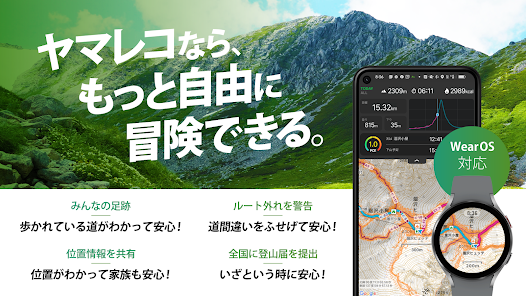
Also compatible with Wear OS smartwatches!
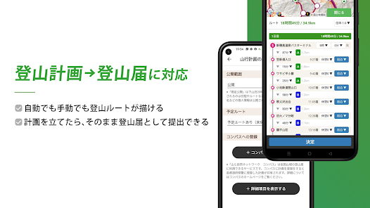
[Before climbing] You can easily create a climbing plan in advance and submit a climbing notification to each prefecture via the Japan Mountain Guide Association's "Compass" system.
You can download the map and route information from your submitted mountain climbing registration before climbing.
[While climbing]
Since you have downloaded the map in advance, you can check your current location using GPS even in the mountains where there is no cell phone signal.
If you also enter your planned route, you can display the arrival time at the summit or trailhead based on your current walking pace. You can also easily save photos and videos while climbing.
In addition, by linking with the "Ima Coco" app and website, you can rest assured that you can safely and in real time communicate your current location to your family and friends while climbing using the "Yamareco" app!
[After climbing]
After you've finished climbing, you can notify your family that you've successfully completed your climb by notifying the Compass system on the app that you're descending.
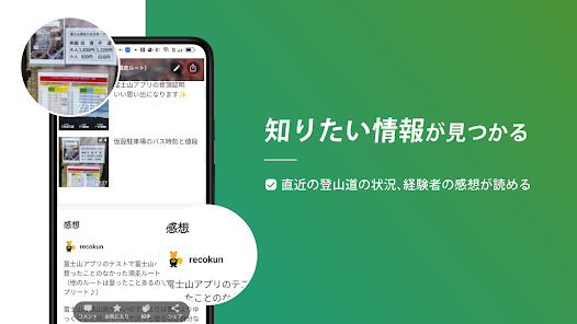
You can easily publish the information on the Internet by leaving the photos you took and GPS logs on the Yamareco website as a "hiking record."
Also, since the information remains on the server, it can be used as a backup in case your smartphone breaks down.
【Features】
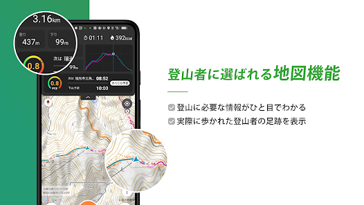
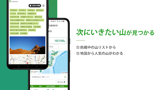
1) Maps can be used offline
Maps from the Geospatial Information Authority of Japan can be downloaded and used as "cache" for domestic use.
Additionally, YamaReco's "Everyone's Footprints" are displayed overlaid, so you can see at a glance where everyone is actually walking (where the mountain trail is).
Of course, it also includes place name data registered in YamaReco, so you can check minor mountains and mountain passes that are not on the map.
2) Submit climbing notification online
It is linked with the "Compass" system operated by the Japan Mountain Guide Association, so you can create a mountain climbing plan with the app and submit it as a mountain climbing notification to Compass.
In each prefecture with which the Japan Mountain Guide Association is affiliated, submitting a plan to Compass is treated as the same as submitting a mountain climbing notification.
Climbing notifications submitted online are used in the event of distress and rescue, which provides higher security than submitting paper submissions to unmanned mountain climbing posts, and allows for a quicker response in the event of an emergency.
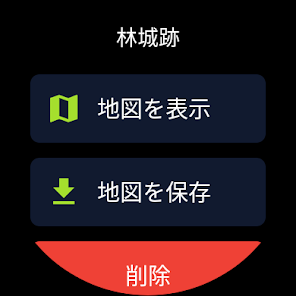
3) Route and map can be downloaded as a set
In addition to pre-prepared area maps, you can also download routes and maps created in your mountain climbing plan.
You can also download routes and maps from other people's mountain records, GPX files, etc.
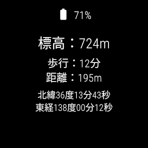
4) Know your arrival time!
The standard course times are listed on the downloaded map, so you can easily visualize where and when you will arrive while climbing.
Also, if you enter the route you plan to walk, it will display what time and minute you plan to arrive at each point you will pass (mountain summit, branch, trailhead, etc.) based on your current walking pace.
I think you can use it as a criterion for deciding when to turn back in the mountain so that you can get down the mountain before sunset.
5) You can leave GPS logs and notes while climbing!
Once you start climbing, you can leave text notes in addition to GPS logs, photos, etc.
You can leave the impression of standing on the mountaintop on the spot!
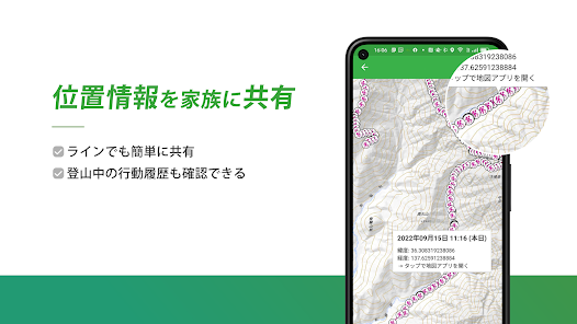
6) You can share your current location with your family!
By taking a GPS log, you can periodically record your current location on YamaReco and check your current location using YamaReco's "Now Here" function.
Family members can check their current location at any time by accessing ``Imakoko'' on their computers or smartphones.
■Now here
https://www.yamareco.com/labo/locviewer/
If you don't particularly need it, you can turn it off from the settings.
Please feel free to use it as needed.
7) You can easily keep a record of your mountain trips!
You can easily create a mountain record using the photos and GPS logs you created while climbing!
A draft is automatically created when you finish climbing, so you can quickly create a record when you have free time, such as on the train home.
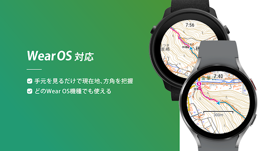
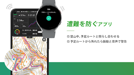
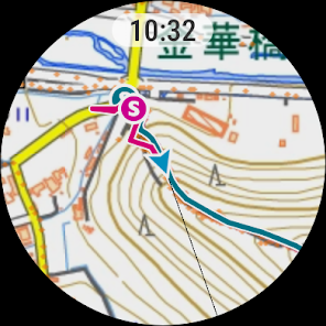
8) Can also be used with smart watches!
If you use a smartwatch equipped with Wear OS by Google, you can easily check the map at hand. You will also be able to receive a warning when you deviate from the planned route, allowing you to enjoy mountain climbing even more safely!
*Applicable to smart watches with Wear OS 2.0 or later.
We have confirmed that it works with Google Pixel Watch, TicWatch Pro 5, Galaxy Watch4, and Suunto 7, but it can also be used with other smart watches compatible with Wear OS 2 or later.
9) You can check the weather forecast for the mountains of Yamaten!
You can check the weather forecast from Yamaten, a weather forecast specializing in mountains, on the app.
Once displayed, you can check the weather forecast many times even when offline.
*You must log in as a Yamaten member or purchase a weather forecast plan.
[Countermeasures when GPS log is interrupted]
- Open the Settings app and make sure the location information mode for your current location information is set to "High Accuracy".
- If you are using a power saving/power saving app, please try excluding the YamaReco app from power saving.
・Try setting the Android settings app "Battery" → "Battery optimization" to disable battery optimization.
[Countermeasures when the current location cannot be obtained/GPS log cannot be obtained from the beginning]
-Make sure you have a clear view of the sky so you can receive signals from GPS satellites.
・Please confirm that your current location is determined using an app that can obtain the status of GPS satellites.
・If you are using an MVNO carrier such as a cheap SIM that does not support A-GPS, it may take about 10 minutes to obtain the initial location information.
- Open the Settings app and make sure the location information mode for your current location information is set to "High Accuracy".
-Try turning off location services and then turning them on again.
・Try restarting your smartphone.
Please read the information on the page below.
Especially with HUAWEI smartphones, the GPS log is interrupted, so settings are required.
https://sites.google.com/site/yamarecomapandroid/help/keep_gps_logging
[About the upper limit on the number of map downloads]
The maximum number of maps that can be downloaded is one for guests and two when logged in (free of charge). There is no upper limit to the number of downloads per month.
You can download the map again for free by deleting the cache that is no longer needed after each climb.
If you are subscribed to YamaReco's premium plan (paid), you can download as many downloads as your smartphone's storage capacity allows.
*The "Everyone's Footprints" function displays the actual path taken, but depending on variation routes and seasons, it may include roads that are not passable, abandoned roads, etc., and the information is guaranteed to be accurate at all times. Not.
When making plans to climb a mountain, please be sure to gather the latest information through the Yamareco website and local related organizations before climbing.
*Please check the Compass website below for prefectures with which Compass is affiliated.
https://www.mt-compass.com/
*To use the smartphone application, you will need to register as a user with Yamareco.
http://www.yamareco.com/
■How to use guide for Android version
https://www.yamareco.com/guide/guide_android/
■Wear OS version usage guide
https://www.yamareco.com/guide/guide_wearos/
This is the only app that can support the activities necessary for mountain climbing, from creating a mountain climbing plan to submitting a mountain climbing report, checking maps while climbing, and creating records after climbing.
Also compatible with Wear OS smartwatches!
[Before climbing] You can easily create a climbing plan in advance and submit a climbing notification to each prefecture via the Japan Mountain Guide Association's "Compass" system.
You can download the map and route information from your submitted mountain climbing registration before climbing.
[While climbing]
Since you have downloaded the map in advance, you can check your current location using GPS even in the mountains where there is no cell phone signal.
If you also enter your planned route, you can display the arrival time at the summit or trailhead based on your current walking pace. You can also easily save photos and videos while climbing.
In addition, by linking with the "Ima Coco" app and website, you can rest assured that you can safely and in real time communicate your current location to your family and friends while climbing using the "Yamareco" app!
[After climbing]
After you've finished climbing, you can notify your family that you've successfully completed your climb by notifying the Compass system on the app that you're descending.
You can easily publish the information on the Internet by leaving the photos you took and GPS logs on the Yamareco website as a "hiking record."
Also, since the information remains on the server, it can be used as a backup in case your smartphone breaks down.
【Features】
1) Maps can be used offline
Maps from the Geospatial Information Authority of Japan can be downloaded and used as "cache" for domestic use.
Additionally, YamaReco's "Everyone's Footprints" are displayed overlaid, so you can see at a glance where everyone is actually walking (where the mountain trail is).
Of course, it also includes place name data registered in YamaReco, so you can check minor mountains and mountain passes that are not on the map.
2) Submit climbing notification online
It is linked with the "Compass" system operated by the Japan Mountain Guide Association, so you can create a mountain climbing plan with the app and submit it as a mountain climbing notification to Compass.
In each prefecture with which the Japan Mountain Guide Association is affiliated, submitting a plan to Compass is treated as the same as submitting a mountain climbing notification.
Climbing notifications submitted online are used in the event of distress and rescue, which provides higher security than submitting paper submissions to unmanned mountain climbing posts, and allows for a quicker response in the event of an emergency.
3) Route and map can be downloaded as a set
In addition to pre-prepared area maps, you can also download routes and maps created in your mountain climbing plan.
You can also download routes and maps from other people's mountain records, GPX files, etc.
4) Know your arrival time!
The standard course times are listed on the downloaded map, so you can easily visualize where and when you will arrive while climbing.
Also, if you enter the route you plan to walk, it will display what time and minute you plan to arrive at each point you will pass (mountain summit, branch, trailhead, etc.) based on your current walking pace.
I think you can use it as a criterion for deciding when to turn back in the mountain so that you can get down the mountain before sunset.
5) You can leave GPS logs and notes while climbing!
Once you start climbing, you can leave text notes in addition to GPS logs, photos, etc.
You can leave the impression of standing on the mountaintop on the spot!
6) You can share your current location with your family!
By taking a GPS log, you can periodically record your current location on YamaReco and check your current location using YamaReco's "Now Here" function.
Family members can check their current location at any time by accessing ``Imakoko'' on their computers or smartphones.
■Now here
https://www.yamareco.com/labo/locviewer/
If you don't particularly need it, you can turn it off from the settings.
Please feel free to use it as needed.
7) You can easily keep a record of your mountain trips!
You can easily create a mountain record using the photos and GPS logs you created while climbing!
A draft is automatically created when you finish climbing, so you can quickly create a record when you have free time, such as on the train home.
8) Can also be used with smart watches!
If you use a smartwatch equipped with Wear OS by Google, you can easily check the map at hand. You will also be able to receive a warning when you deviate from the planned route, allowing you to enjoy mountain climbing even more safely!
*Applicable to smart watches with Wear OS 2.0 or later.
We have confirmed that it works with Google Pixel Watch, TicWatch Pro 5, Galaxy Watch4, and Suunto 7, but it can also be used with other smart watches compatible with Wear OS 2 or later.
9) You can check the weather forecast for the mountains of Yamaten!
You can check the weather forecast from Yamaten, a weather forecast specializing in mountains, on the app.
Once displayed, you can check the weather forecast many times even when offline.
*You must log in as a Yamaten member or purchase a weather forecast plan.
[Countermeasures when GPS log is interrupted]
- Open the Settings app and make sure the location information mode for your current location information is set to "High Accuracy".
- If you are using a power saving/power saving app, please try excluding the YamaReco app from power saving.
・Try setting the Android settings app "Battery" → "Battery optimization" to disable battery optimization.
[Countermeasures when the current location cannot be obtained/GPS log cannot be obtained from the beginning]
-Make sure you have a clear view of the sky so you can receive signals from GPS satellites.
・Please confirm that your current location is determined using an app that can obtain the status of GPS satellites.
・If you are using an MVNO carrier such as a cheap SIM that does not support A-GPS, it may take about 10 minutes to obtain the initial location information.
- Open the Settings app and make sure the location information mode for your current location information is set to "High Accuracy".
-Try turning off location services and then turning them on again.
・Try restarting your smartphone.
Please read the information on the page below.
Especially with HUAWEI smartphones, the GPS log is interrupted, so settings are required.
https://sites.google.com/site/yamarecomapandroid/help/keep_gps_logging
[About the upper limit on the number of map downloads]
The maximum number of maps that can be downloaded is one for guests and two when logged in (free of charge). There is no upper limit to the number of downloads per month.
You can download the map again for free by deleting the cache that is no longer needed after each climb.
If you are subscribed to YamaReco's premium plan (paid), you can download as many downloads as your smartphone's storage capacity allows.
*The "Everyone's Footprints" function displays the actual path taken, but depending on variation routes and seasons, it may include roads that are not passable, abandoned roads, etc., and the information is guaranteed to be accurate at all times. Not.
When making plans to climb a mountain, please be sure to gather the latest information through the Yamareco website and local related organizations before climbing.
*Please check the Compass website below for prefectures with which Compass is affiliated.
https://www.mt-compass.com/
*To use the smartphone application, you will need to register as a user with Yamareco.
http://www.yamareco.com/
■How to use guide for Android version
https://www.yamareco.com/guide/guide_android/
■Wear OS version usage guide
https://www.yamareco.com/guide/guide_wearos/
Updated on
Safety starts with understanding how developers collect and share your data. Data privacy and security practices may vary based on your use, region, and age. The developer provided this information and may update it over time.


What's new
バージョン8.0.0
・各種ライブラリのアップデート
・各種ライブラリのアップデート


