eINAGA geo
1K+
Downloads

Everyone
info


About this app
Mobility application that allows simple digitalization over the territory of Aragón in order to attach the application files presented in INAGA, if applicable, to the files generated by the application (ETRS89 30N).
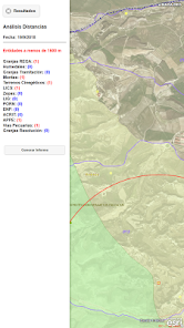
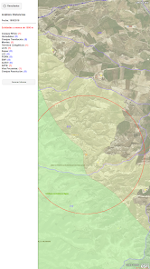
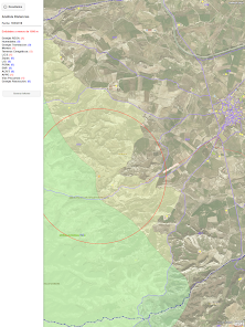
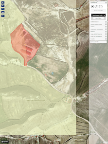
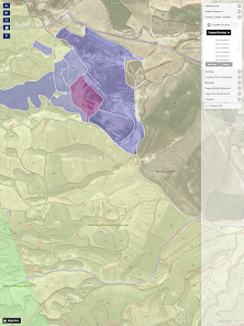
From the GIS cartography you can access the data of
the official cartography of the Natura 2000 Network, Protected Natural Spaces, Critical Areas, PORN, Montes de UP, livestock trails, hunting grounds.
In addition, on these same layers a basic analysis of distances to the previously digitized area can be carried out, with a radio parameterizable by the user.
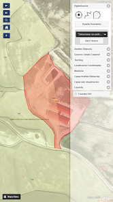
It can also be consulted on the map, the virtual office of Cadastre and the layers of SIGPAC, in order to facilitate the location in the field.
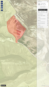
The digitization can be done in lines, points or polygons at a minimum scale of 1: 25.0000, these digitized entities can be saved in your device, to recover later in the same application and reanalyze the area of action if desired. They are saved in txt and geojson format.
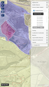
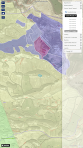
On the other hand, it allows obtaining lists of parcels directly affected on the map of both Cadastre (Plots and Subparcelas) and SIGPAC Enclosures and save them in text files.
It incorporates utilities of interest such as TRACKING, allowing the saving of the points obtained and their subsequent recovery, as well as allowing analysis on the generated route.
Likewise, it incorporates different tools of interest
• Measurement of surfaces and distances
• Saving and recovery of scan files
• Geopositioning and Tracking. With saved tracking points and territorial analysis of it.
• Selection of Layers for generation of Analysis.
• PDF saved of the analyzes performed.
• Layers only visualization (SIGPAC, CATASTRO, IGN).
• Consultation virtual office of cadastre.
• Change of Base Map
This project has been financed through FEDER Funds
From the GIS cartography you can access the data of
the official cartography of the Natura 2000 Network, Protected Natural Spaces, Critical Areas, PORN, Montes de UP, livestock trails, hunting grounds.
In addition, on these same layers a basic analysis of distances to the previously digitized area can be carried out, with a radio parameterizable by the user.
It can also be consulted on the map, the virtual office of Cadastre and the layers of SIGPAC, in order to facilitate the location in the field.
The digitization can be done in lines, points or polygons at a minimum scale of 1: 25.0000, these digitized entities can be saved in your device, to recover later in the same application and reanalyze the area of action if desired. They are saved in txt and geojson format.
On the other hand, it allows obtaining lists of parcels directly affected on the map of both Cadastre (Plots and Subparcelas) and SIGPAC Enclosures and save them in text files.
It incorporates utilities of interest such as TRACKING, allowing the saving of the points obtained and their subsequent recovery, as well as allowing analysis on the generated route.
Likewise, it incorporates different tools of interest
• Measurement of surfaces and distances
• Saving and recovery of scan files
• Geopositioning and Tracking. With saved tracking points and territorial analysis of it.
• Selection of Layers for generation of Analysis.
• PDF saved of the analyzes performed.
• Layers only visualization (SIGPAC, CATASTRO, IGN).
• Consultation virtual office of cadastre.
• Change of Base Map
This project has been financed through FEDER Funds
Updated on
Data safety
Developers can show information here about how their app collects and uses your data. Learn more about data safety

No information available
What's new
Botón "acercar" del panel de información izquierdo : zoom a la entidad geográfica.


