Kecskeméti Menetrend
Contains adsIn-app purchases
4.5star
47 reviews
1K+
Downloads

Everyone
info
About this app
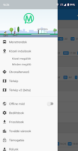
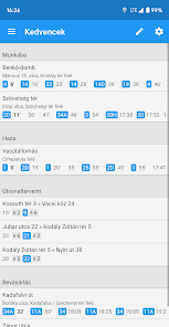
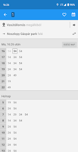
Timetable and route planning application for the local public transport network of Kecskemét. The app allows you to browse the list of local flights, view timetables, view the route and travel times of each flight in text or map form, and get information about nearby stops. You also have the option of planning a route, with any transfer and walk. With Favorites, you can collect flights, stops, and directions that interest you, and right after launching the app, you can review the information you need on a single screen.
Key features:
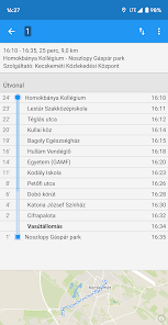
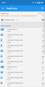
✓ offline timetable information (flights, stops, journey times, etc.)
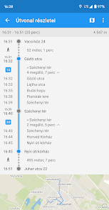
✓ Offline route planner with detailed settings
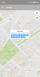
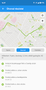
✓ display flights on the map with routes fitted to the streets
✓ List nearby stops by distance and direction for easier orientation
✓ downloadable offline map
✓ Widget that can be placed on the home screen
✓ regular, automatic updates
✓ Fast operation even on older devices
✓ modern user interface
✓ small database (150 kB) and even smaller data traffic when updating (60-80 kB)
✓ Both the application and the database can be saved to the SD card
✓ and much more ...
Important informations:
• the app does not contain real-time data, all information displayed is from static schedules
• the widget must have the app installed on its internal memory to work (apps installed on the SD card cannot have widgets)
The source of the timetable data is the GTFS database available at https://github.com/derilevi/gtfs_kecskemet. Street names, some of the trails, and offline map data come from OpenStreetMap. The information displayed is usually accurate, but minor errors may occur at any time. The developers are not responsible for the authenticity of the data and for any damage or inconvenience resulting from the use of the application.
If possible, before starting the trip, find out about the signs at the stops or from the website of the Kecskemét Transport Center (KeKo) (https://keko.hu/).
Key features:
✓ offline timetable information (flights, stops, journey times, etc.)
✓ Offline route planner with detailed settings
✓ display flights on the map with routes fitted to the streets
✓ List nearby stops by distance and direction for easier orientation
✓ downloadable offline map
✓ Widget that can be placed on the home screen
✓ regular, automatic updates
✓ Fast operation even on older devices
✓ modern user interface
✓ small database (150 kB) and even smaller data traffic when updating (60-80 kB)
✓ Both the application and the database can be saved to the SD card
✓ and much more ...
Important informations:
• the app does not contain real-time data, all information displayed is from static schedules
• the widget must have the app installed on its internal memory to work (apps installed on the SD card cannot have widgets)
The source of the timetable data is the GTFS database available at https://github.com/derilevi/gtfs_kecskemet. Street names, some of the trails, and offline map data come from OpenStreetMap. The information displayed is usually accurate, but minor errors may occur at any time. The developers are not responsible for the authenticity of the data and for any damage or inconvenience resulting from the use of the application.
If possible, before starting the trip, find out about the signs at the stops or from the website of the Kecskemét Transport Center (KeKo) (https://keko.hu/).
Updated on
Safety starts with understanding how developers collect and share your data. Data privacy and security practices may vary based on your use, region, and age. The developer provided this information and may update it over time.

No data shared with third parties
Learn more about how developers declare sharing

This app may collect these data types
App activity, App info and performance, and Device or other IDs

Data is encrypted in transit

Data can’t be deleted
Ratings and reviews
4.5
47 reviews

Mátyás Dankó
- Flag inappropriate
August 18, 2020
Nagyon hasznos, kiválóan működik
What's new
Menetrend alkalmazásainkat egységesítettük: keresd Kecskemét és 15 másik város menetrendjét a megújult menetrend.app alkalmazásunkban. A Kecskeméti Menetrend alkalmazás szeptember végéig lesz elérhető. Kérjük, amint teheted, frissíts az új alkalmazásra.
További infókért kövesd a blogunk (https://blog.menetrend.app/) vagy a Facebook oldalunk (https://www.facebook.com/MenetrendApp)
További infókért kövesd a blogunk (https://blog.menetrend.app/) vagy a Facebook oldalunk (https://www.facebook.com/MenetrendApp)


