Offroad - Route Planner
10K+
Downloads

Everyone
info
About this app
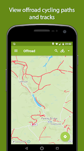
Offroad allows you to display offroad rights of way easily on a map. Many mapping programs show bridleways or footpaths but only when extremely zoomed in on the map. Or they might not show access at all. With Offroad you can move the map to where you want to show paths, click search and the app will download and show an overlay of the paths at any zoom level. Handy for planning routes to link offroad sections. Click save to keep the paths downloaded for offline use.
Offroad uses a service called Overpass API to retrieve data from Open street maps. You can change the search function to show not just rights of way but also for drinking points, toilets and in future release any custom search. This can be done in the overpass menu.
Modifiers can be used to style the overlays based on different properties of the lines. The tags that are saved from the Overpass API are designation, highway, surface, tracktype, bicycle, foot, motor_vehicle and horse. Search open street maps to see there permitted values.
Default overlays included are:
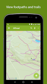
Foot- for showing footpaths and bridleways
Bike- showing bridleways and cycleways
Hiking route- showing national or regional trails
MTB route- showing national or regional trails
Motor Vehicle- Showing any track that has moto access allowed.(Double check before using as Open Street Maps it not 100%)
Water Point- Searches for amenity=Drinking water(Prone to been miss labelled)
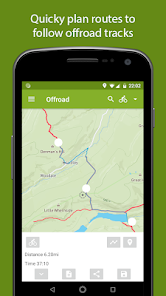
To create routes you drop way points in the centre of the map, either auto or manual. Auto will follow paths and roads and so on, where manual will just connect a straight line between the points. Auto should be preferred, giving you much better distance accuracy, though with open street maps, data is not always faultless. If junctions are not connected or paths are missing this is where manual comes in. You can quick jump across the problem area and continue using auto again.
Save your route for viewing later or export a gpx file to share with other applications on your phone, like Ghostracer.
Import any GeoJson to show on the map.
Open street map is built by a community of mappers. No right of way should be taken at 100 percent accuracy.
If there's a problem with the map then go fix it at Openstreetmaps.org and contribute. And get offroad.
Offroad uses a service called Overpass API to retrieve data from Open street maps. You can change the search function to show not just rights of way but also for drinking points, toilets and in future release any custom search. This can be done in the overpass menu.
Modifiers can be used to style the overlays based on different properties of the lines. The tags that are saved from the Overpass API are designation, highway, surface, tracktype, bicycle, foot, motor_vehicle and horse. Search open street maps to see there permitted values.
Default overlays included are:
Foot- for showing footpaths and bridleways
Bike- showing bridleways and cycleways
Hiking route- showing national or regional trails
MTB route- showing national or regional trails
Motor Vehicle- Showing any track that has moto access allowed.(Double check before using as Open Street Maps it not 100%)
Water Point- Searches for amenity=Drinking water(Prone to been miss labelled)
To create routes you drop way points in the centre of the map, either auto or manual. Auto will follow paths and roads and so on, where manual will just connect a straight line between the points. Auto should be preferred, giving you much better distance accuracy, though with open street maps, data is not always faultless. If junctions are not connected or paths are missing this is where manual comes in. You can quick jump across the problem area and continue using auto again.
Save your route for viewing later or export a gpx file to share with other applications on your phone, like Ghostracer.
Import any GeoJson to show on the map.
Open street map is built by a community of mappers. No right of way should be taken at 100 percent accuracy.
If there's a problem with the map then go fix it at Openstreetmaps.org and contribute. And get offroad.
Updated on
Safety starts with understanding how developers collect and share your data. Data privacy and security practices may vary based on your use, region, and age. The developer provided this information and may update it over time.


What's new
0.5.0- Added UK map style to highlight rights of way
- Mapbox update - 3D maps option
- Simple place name search
0.4.2 -Location button
-Horse overlay
-Add new point between points in route planning(hover line)
0.4.0 Added modifiers, change lines based on properties.
0.3.3 Revert navigation to mapbox (better offroad)
0.3.0 Support for importing GeoJson files. Swipe to hide/delete overpasses.
0.2.1 Edit Overlays to change colour and line width that show on the map. Added toilets to list.

