
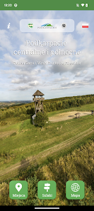
Podkarpacie centralno-północne
1K+
Downloads

Everyone
info

About this app
The Podkarpackie Voivodeship and the Central Mountain Tourism Center of PTTK invite you to the trails of Central and Northern Podkarpacie - provided by the only and free application containing all PTTK hiking trails located in Roztocze, the San and Vistula Valleys and Rzeszów - the city and region. The application also contains 100 tourist and sightseeing attractions located near the trails.
The trails of the rest of the Podkarpackie Voivodeship (Bieszczady Mountains and Low Beskids), as well as the Slovak border areas, can be found in the "Mountains Without Borders" mobile application and on the "Mountains Without Borders" trail platform.
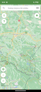
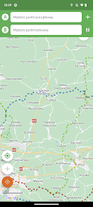
The application provides a unique set of maps: topographic, aerial, relief, and Open Street Map - thanks to which you will see all the details of the terrain, always find the trail, or plan any route and you will be able to navigate it. You can download fragments of the OSM map to your phone and not worry about the lack of coverage (and the map).
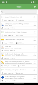
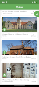
Each hiking trail presented in the application is assigned to nearby attractive places in terms of sightseeing - in the field of culture (temples, castles and palaces, museums, etc.), nature (national parks, reserves, water reservoirs, etc.) and tourist facilities (shelters, sheds, campsites, etc.).
The application allows you to: route and navigate trails, use many different maps, offline download OSM map and trails and elevation data, see all information about a given trail or POI, read the distance and azimuth to any place and its altitude, share your position, check the weather forecast for any place, see interesting places in the area on the map, navigate a route created via a web map, save and share your favorite places and trails, and save your route and export it to a file. You can also load your own .gpx file and navigate by it.
On the website map of the "Central and Northern Podkarpacie" trail platform, you will find even more maps - including the Compass tourist map and detailed topographic maps in the scale of 1:10,000. You can also plan a trip route there, which you can easily transfer to the application and use for navigation. The application uses the same data about objects and trails that are presented on the map and in the sightseeing portal operating as part of the "Central and Northern Podkarpacie" trail platform
The routes of PTTK hiking trails are updated on a regular basis. The PTTK Branch administering the given trail is responsible for keeping the course of the PTTK walking trail shown in the application up-to-date.
Only PTTK hiking trails are administered by PTTK, which is not responsible for the condition of tourist trails marked out by other institutions or organizations.
If you encounter a discrepancy between the course of the trail in the field and the route shown in the application, we will be very grateful if you inform us about the problem using the Sign wrong?
The trails of the rest of the Podkarpackie Voivodeship (Bieszczady Mountains and Low Beskids), as well as the Slovak border areas, can be found in the "Mountains Without Borders" mobile application and on the "Mountains Without Borders" trail platform.
The application provides a unique set of maps: topographic, aerial, relief, and Open Street Map - thanks to which you will see all the details of the terrain, always find the trail, or plan any route and you will be able to navigate it. You can download fragments of the OSM map to your phone and not worry about the lack of coverage (and the map).
Each hiking trail presented in the application is assigned to nearby attractive places in terms of sightseeing - in the field of culture (temples, castles and palaces, museums, etc.), nature (national parks, reserves, water reservoirs, etc.) and tourist facilities (shelters, sheds, campsites, etc.).
The application allows you to: route and navigate trails, use many different maps, offline download OSM map and trails and elevation data, see all information about a given trail or POI, read the distance and azimuth to any place and its altitude, share your position, check the weather forecast for any place, see interesting places in the area on the map, navigate a route created via a web map, save and share your favorite places and trails, and save your route and export it to a file. You can also load your own .gpx file and navigate by it.
On the website map of the "Central and Northern Podkarpacie" trail platform, you will find even more maps - including the Compass tourist map and detailed topographic maps in the scale of 1:10,000. You can also plan a trip route there, which you can easily transfer to the application and use for navigation. The application uses the same data about objects and trails that are presented on the map and in the sightseeing portal operating as part of the "Central and Northern Podkarpacie" trail platform
The routes of PTTK hiking trails are updated on a regular basis. The PTTK Branch administering the given trail is responsible for keeping the course of the PTTK walking trail shown in the application up-to-date.
Only PTTK hiking trails are administered by PTTK, which is not responsible for the condition of tourist trails marked out by other institutions or organizations.
If you encounter a discrepancy between the course of the trail in the field and the route shown in the application, we will be very grateful if you inform us about the problem using the Sign wrong?
Updated on
Safety starts with understanding how developers collect and share your data. Data privacy and security practices may vary based on your use, region, and age. The developer provided this information and may update it over time.

No data shared with third parties
Learn more about how developers declare sharing

This app may collect these data types
Device or other IDs

Data isn’t encrypted
Data can’t be deleted


