GPS Map Camera - GeoTag
Contains adsIn-app purchases
3.2star
715 reviews
100K+
Downloads

Everyone
info
About this app
If GeoTag runs properly, please, put a 5* rating and a comment with wish-features - you will help me to perfect the app! https://www.facebook.com/geotag.android/
GeoTag app was created to geotag (add exif data) the smartphone photos with high accuracy (while unable to sync with DSLR cams, GeoTag can add and edit geotags to any offline images stored on your smartphone). This geotagging app allows:
- show and share your current GPS location (and show all enabled geodata - see Screen Settings to set defaults);
- take photos and video while displaying GPS location and accuracy on the screen,
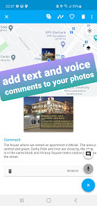
- add text and voice notes to photos (available from Image mode - tap a photo you want to edit);
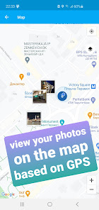
- display your photos with geotags on the map (view your photos in a geoalbum);
- share photos;
- export geodata as KML, CSV or XLS files;
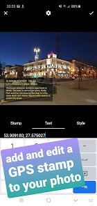
- add and edit customized geostamps / timestamps to images and videos:
- edit the GPS coordinates and other geodata of the photo, fake photo GPS.
With GeoTag you can accomplish the following:
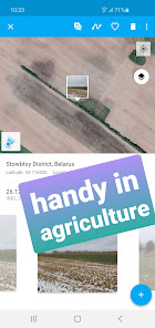
- accumulate geodata in agriculture, which is essential in farming;
- take, edit (fake) GPS data of a picture of your phone camera for private use;
- take a photo with a geotag of a fallen tree, pothole or other everyday hazard you want to report;
- geotag a car that was parked against the rules;
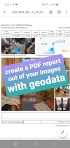
- in real estate: photograph a property on sale to make a PDF report and share with your friend...
Please, note that the time required to obtain GPS coordinates with your smartphone – normally 1-2 minutes - depends on weather, network coverage and other factors like nearby trees, buildings and simply being outdoors. Using the geolocation function of your device along with the camera drains the phone battery.
How GeoTag works in detail:
GeoTag can be used outdoors (using indoors reduces GPS accuracy) on smartphones that support location to take pictures with GPS exif data and share them. With GeoTag on your smartphone you can:
in Camera Mode (you enter this mode when you launch the app):
- tune the settings to be displayed on the screen (coordinates, time, address, etc.)
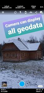
- take pictures while displaying real time coordinates, altitude and accuracy of your location;
- geotag pictures - save your coordinates, weather, address, date / time of taking pictures as exif;
- share your picture or geodata only (coordinates, etc.);
- jump to the last taken image to enter Image Mode
in Image Mode:
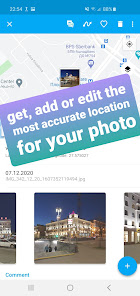
- view images, their coordinates and location on the map (maps: satellite, standard);
- swipe between images from the last taken one to view or delete them and check their map location;
- add a geostamp / timestamp to any image on any spot;
- choose Edit info to edit azimuth and other geodata;
- choose color / size / transparency of the geostamp / timestamp;
- export exif as kml file;
- add a text or voice comment (please note, that while a text comment becomes a part of the image file stored in exif data and can be shared, a voice note is not added to the file and cannot be shared along with it)
- images can be shared via Picasa, Google Drive … keeping exif data
- long-tap an image icon on map to edit location and azimuth.
in Gallery Mode:
- arrange images by name / time of creation / distance;
- choose a folder to view PDF reports;
- choose a folder on your camera to view images on the map;
- short-tap an image to enter Image Mode.
Share your ideas through Feedback section!
GeoTag app was created to geotag (add exif data) the smartphone photos with high accuracy (while unable to sync with DSLR cams, GeoTag can add and edit geotags to any offline images stored on your smartphone). This geotagging app allows:
- show and share your current GPS location (and show all enabled geodata - see Screen Settings to set defaults);
- take photos and video while displaying GPS location and accuracy on the screen,
- add text and voice notes to photos (available from Image mode - tap a photo you want to edit);
- display your photos with geotags on the map (view your photos in a geoalbum);
- share photos;
- export geodata as KML, CSV or XLS files;
- add and edit customized geostamps / timestamps to images and videos:
- edit the GPS coordinates and other geodata of the photo, fake photo GPS.
With GeoTag you can accomplish the following:
- accumulate geodata in agriculture, which is essential in farming;
- take, edit (fake) GPS data of a picture of your phone camera for private use;
- take a photo with a geotag of a fallen tree, pothole or other everyday hazard you want to report;
- geotag a car that was parked against the rules;
- in real estate: photograph a property on sale to make a PDF report and share with your friend...
Please, note that the time required to obtain GPS coordinates with your smartphone – normally 1-2 minutes - depends on weather, network coverage and other factors like nearby trees, buildings and simply being outdoors. Using the geolocation function of your device along with the camera drains the phone battery.
How GeoTag works in detail:
GeoTag can be used outdoors (using indoors reduces GPS accuracy) on smartphones that support location to take pictures with GPS exif data and share them. With GeoTag on your smartphone you can:
in Camera Mode (you enter this mode when you launch the app):
- tune the settings to be displayed on the screen (coordinates, time, address, etc.)
- take pictures while displaying real time coordinates, altitude and accuracy of your location;
- geotag pictures - save your coordinates, weather, address, date / time of taking pictures as exif;
- share your picture or geodata only (coordinates, etc.);
- jump to the last taken image to enter Image Mode
in Image Mode:
- view images, their coordinates and location on the map (maps: satellite, standard);
- swipe between images from the last taken one to view or delete them and check their map location;
- add a geostamp / timestamp to any image on any spot;
- choose Edit info to edit azimuth and other geodata;
- choose color / size / transparency of the geostamp / timestamp;
- export exif as kml file;
- add a text or voice comment (please note, that while a text comment becomes a part of the image file stored in exif data and can be shared, a voice note is not added to the file and cannot be shared along with it)
- images can be shared via Picasa, Google Drive … keeping exif data
- long-tap an image icon on map to edit location and azimuth.
in Gallery Mode:
- arrange images by name / time of creation / distance;
- choose a folder to view PDF reports;
- choose a folder on your camera to view images on the map;
- short-tap an image to enter Image Mode.
Share your ideas through Feedback section!
Updated on
Safety starts with understanding how developers collect and share your data. Data privacy and security practices may vary based on your use, region, and age. The developer provided this information and may update it over time.

This app may share these data types with third parties
Device or other IDs

No data collected
Learn more about how developers declare collection

Data is encrypted in transit

Data can’t be deleted
Ratings and reviews
3.2
703 reviews

thebrontokz
- Flag inappropriate
- Show review history
April 25, 2024
Not sure what i did wrong, but i cant put date×tamp at all. Everytime i turn the setting on, it will turn itself off again once i exit setting.
4 people found this review helpful
Prometheus Interactive LLC
April 25, 2024
Hello, thank you for your review. We are sorry to hear that you might be experiencing issues. We will be happy to assist you further if you clarify your review. Here is our email address, please, reach out to our Support Team so that we can advise you properly: support.geotag@useprometheus.app

Ján Florovič
- Flag inappropriate
April 26, 2024
Not working well, needs to be worked out a lot to fix serious bugs!🙏 ... and such an expensive subscription for this! 🙏😱🙏
1 person found this review helpful
Prometheus Interactive LLC
April 26, 2024
Hi.
Sorry to hear that the price for the Premium subscription seems high to you. Please, note that the App on the Premium version opens up many exciting features and opportunities for you and it is definitely worth the price. Reach out to our support team with the details of the issue at support.geotag@useprometheus.app for further assistance.

Martigan Wright
- Flag inappropriate
September 23, 2021
Okay I am highly disappointed. At first, the app seems to do an okay job. It reads out the coordinates saved in photos and adds location data. Great. But after putting stamps on 10 photos it will only work if you subscribe (0.99 EUR/month or 5.99 EUR/year). That's awfully expensive for an app that gives me very limited editability - I can't even change the way that coordinates are being displayed. Let alone the order or what appears where. 0.99 EUR lifetime would be okay, not more.
71 people found this review helpful
Prometheus Interactive LLC
September 26, 2021
Martigan, you're very democratic and impartial, thank you for that. So $15k+ worth of app coding is too expensive for you?.. Use MyGps and a notepad to put down the coordinates. It's surely cheaper. There are several formats to the coordinates in the Settings, by the way.


