Geocam Pro
4.1star
358 reviews
10K+
Downloads

Everyone
info
About this app
Geocam by Wazar is the leading geophoto and video application for Android. It uses augmented reality to show on top of your camera a layer of geographical information such as Compass orientation, GPS position and different phone inclinations like a theodolite optical instrument.
What you can do with Geocam:
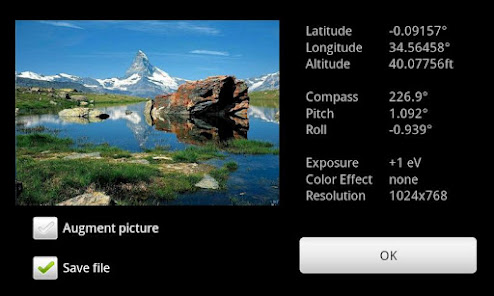
* Geo-Pictures: photos that have an extra layer of geographical data such as GPS position, compass orientation, pitch, roll, altitude, etc. This data is added into the EXIF metadata and can selectively be drawn on images as an overlay. You can see all you pictures on Google Maps or on Google Earth on your personal computer with the export feature. You can share those albums with anyone who can run Google Earth.
* Geo-Videos (Pro only): the first and only app to let you record videos with an embed layer of geographical data. A useful addition to pictures. With Geocam Studio (available on geocam.wazar-apps.com), customize and export these videos and share them.
* Geo-Reports: export and share PDF reports with your pictures, bearings, their location on a map and your comments
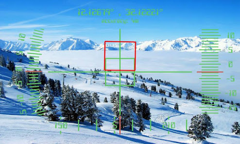
* Bearings: Geocam is an accurate measure tool. It shows your compass orientation (choose between magnetic or geographic North), your inclination and elevation with readable cursors (like a cockpit HUD). It can be used in terrain mapping, on a glide, sailing, mountain biking...
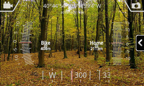
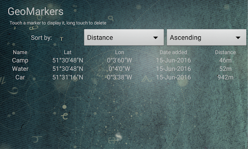
* Geo-Caching: prepare a list of key places in an area and view them with your camera on augmented reality: name, distance. You will not require a data connection offline so it can be used when hiking abroad, when visiting another city... This will help you make sure you are going in the right direction and give you remaining distance. You can also add markers during your hike with the "Add here" option, for example to flag the base camp, a water source, or anything interesting you find on your way.
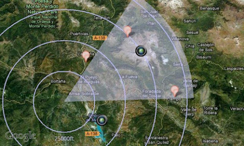
* Measurements: Evaluate the distance to any object with the triangulation feature. You can also measure its height once the distance is known. This is not done by showing any unreadable cursor on the screen, but with mathematical formulas. Choose between metric and imperial measure systems.
Geocam supports extensive customisation including:
* Selecting which indicators to display on the HUD and whether to save them or not on pictures
* Metric and imperial systems
* GPS Formats: Decimal degrees, degrees/minutes/second, MGRS, UTM
* True north or magnetic north
* Degrees or Mils compass readings
* Percentage or degree slopes
* Calibrating "zero" pitch and roll to custom values to measure differences
* Different themes including a "cockpit" style or a "hi-vis" style
IMPORTANT NOTE: If you are facing an issue, we cannot help you if you only leave a review. Do get it touch by email so we can hep you. We do reply to all emails and regularly push out fixes to reported problems. By all means please do get in touch if you are experiencing difficulties.
What you can do with Geocam:
* Geo-Pictures: photos that have an extra layer of geographical data such as GPS position, compass orientation, pitch, roll, altitude, etc. This data is added into the EXIF metadata and can selectively be drawn on images as an overlay. You can see all you pictures on Google Maps or on Google Earth on your personal computer with the export feature. You can share those albums with anyone who can run Google Earth.
* Geo-Videos (Pro only): the first and only app to let you record videos with an embed layer of geographical data. A useful addition to pictures. With Geocam Studio (available on geocam.wazar-apps.com), customize and export these videos and share them.
* Geo-Reports: export and share PDF reports with your pictures, bearings, their location on a map and your comments
* Bearings: Geocam is an accurate measure tool. It shows your compass orientation (choose between magnetic or geographic North), your inclination and elevation with readable cursors (like a cockpit HUD). It can be used in terrain mapping, on a glide, sailing, mountain biking...
* Geo-Caching: prepare a list of key places in an area and view them with your camera on augmented reality: name, distance. You will not require a data connection offline so it can be used when hiking abroad, when visiting another city... This will help you make sure you are going in the right direction and give you remaining distance. You can also add markers during your hike with the "Add here" option, for example to flag the base camp, a water source, or anything interesting you find on your way.
* Measurements: Evaluate the distance to any object with the triangulation feature. You can also measure its height once the distance is known. This is not done by showing any unreadable cursor on the screen, but with mathematical formulas. Choose between metric and imperial measure systems.
Geocam supports extensive customisation including:
* Selecting which indicators to display on the HUD and whether to save them or not on pictures
* Metric and imperial systems
* GPS Formats: Decimal degrees, degrees/minutes/second, MGRS, UTM
* True north or magnetic north
* Degrees or Mils compass readings
* Percentage or degree slopes
* Calibrating "zero" pitch and roll to custom values to measure differences
* Different themes including a "cockpit" style or a "hi-vis" style
IMPORTANT NOTE: If you are facing an issue, we cannot help you if you only leave a review. Do get it touch by email so we can hep you. We do reply to all emails and regularly push out fixes to reported problems. By all means please do get in touch if you are experiencing difficulties.
Updated on
Data safety
Developers can show information here about how their app collects and uses your data. Learn more about data safety

No information available
Ratings and reviews
4.1
346 reviews

Colin Coleman
- Flag inappropriate
October 7, 2020
Looks great on the phone screen in live view with augmented reality, but recorded video is very low quality even though it was set high in the app. The graphic overlays also do not show in the recorded file when transferred to the desktop PC. The beta Geocam Studio companion app for the desktop is a pain to just get running and when it does you find out that the videos don't look like the sample on their website. The files do work on Youtube though, only at 480p resolution.
164 people found this review helpful

Agustin Lobo
- Flag inappropriate
February 27, 2024
Useful app, but the camera cannot be shut using the buttons (which is possible with the standard camera app) and lacks a timer. The remote control that is used with an stick activates the zoom instead of shutting the camera.
5 people found this review helpful

A Google user
- Flag inappropriate
November 4, 2019
Description is misleading. Geo video is useless if I can't share or export to . kml/.kmz and .mp4 or equivalent. It's the only reason I bought it. (Would be nice to export .mp4 with the video and PIP of google maps position in a corner of the frame somewhere. So you're seeing the what and where at the same time.)
102 people found this review helpful
Wazar-Apps
November 19, 2019
Videos can be exported from the Geocam studio on your desktop. Mobile devices do not handle this well. Can you please contact us on info@wazar-apps.com? Thanks
What's new
Mean Sea Level altitude mode
Fix shadow in custom watermark text
Fix shadow in custom watermark text