
Geoportal Dolny Śląsk
1K+
Downloads

Everyone
info


About this app
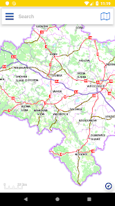
The application provides access to spatial data collection services from the area of the Lower Silesian Voivodeship.
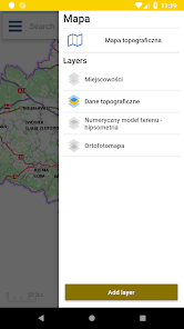
The application enables:
a.displaying a map made available by the tiled spatial data services of the UMWD,
b. navigation in the map window - moving, zooming out, enlarging the map view,
c. using the GPS signal - recording and saving the route, approaching the current location, dynamically moving the map based on a changing location,
d. searching for addresses,
e. length and area measurements on the map,
f. Adding external WMS services,
Updated on
Safety starts with understanding how developers collect and share your data. Data privacy and security practices may vary based on your use, region, and age. The developer provided this information and may update it over time.

No data shared with third parties
Learn more about how developers declare sharing

No data collected
Learn more about how developers declare collection
App support
About the developer
GISPARTNER SP Z O O
hkurpiewski@gispartner.pl
Ul. Jana Długosza 60
51-162 Wrocław
Poland
+48 693 824 303


