
Avia Maps Aeronautical Charts
In-app purchases
4.3star
1.71K reviews
100K+
Downloads

Everyone
info


About this app
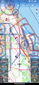
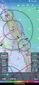
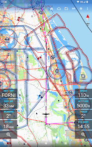
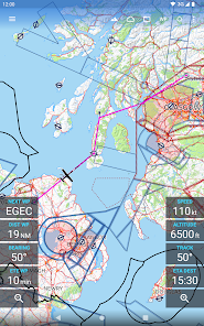
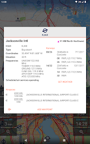
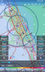
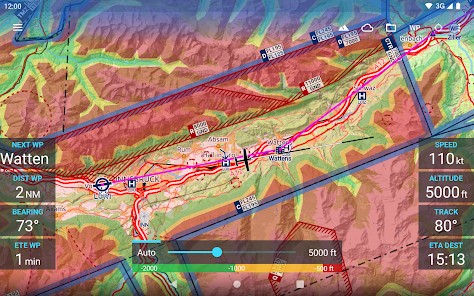
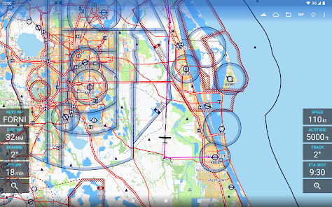
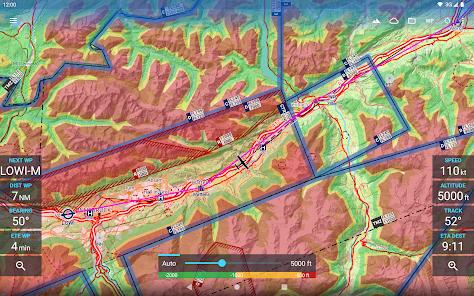
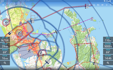
The reliable and straightforward aviation maps for pilots and aerospace enthusiasts around the world. The app is suited for pre-flight planning as well as in-flight navigation. Simply choose any 5 by 5 degree area on earth and download relevant data for offline use. The map features over 65000 airports, 9000 navaids and 15000 waypoints around the globe, just as airspaces for currently 62 countries on all continents (except Antarctica). Countries with airspace data include the United States and Canada, Europe, Australia and New Zealand.
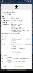
Global, high resolution weather forecasts from the German DWD and US American NOAA provide accurate map layers for cloud cover, ceiling, precipitation, wind on the ground as well as aloft. The data is downloaded onto the device, so you can check the forecast even during flight without cell reception. To retrieve the latest METAR and TAF at your destination airport it is integrated with Avia Weather.
A digital elevation model supports you with planning your route in the mountains. During flight the terrain overlay will dynamically color hills and mountains on the map depending on your current altitude to increase your situational awareness.
To enhance safety, Avia Maps can display traffic information from your favorite ADS-B receiver or from the SafeSky app directly on the map. It supports receiving traffic data using the GDL90 format, which is supported by most portable ADS-B receivers like SkyEcho or Stratux. If you do not have a receiver, SafeSky can provide traffic data using an internet connection only.
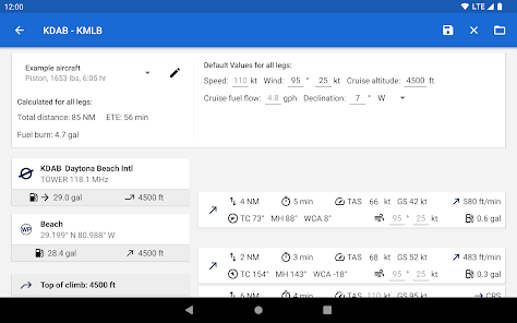
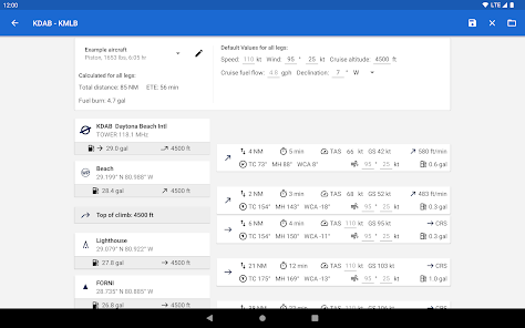
For the most accurate performance calculations you can create multiple aircraft profiles from handbook values for climb performance, fuel consumption etc. Route calculations will use these profiles and even consider engine type and fuel burn for climb performance, employing common formulae used in aerospace engineering. From as little as four carefully chosen data points the app can accurately recreate the climb performance diagram in your POH.
For clarity and commonality to paper charts the map is themed in the style of ICAO Annex 4 (Aeronautical Charts). If you use the app on multiple devices you can synchronize your routes, aircraft profiles and user waypoints between them.
This is a trial app with full features. After an evaluation period of 30 days you will have to buy a perpetual license from within the app or subscribe to the professional tier.
Global, high resolution weather forecasts from the German DWD and US American NOAA provide accurate map layers for cloud cover, ceiling, precipitation, wind on the ground as well as aloft. The data is downloaded onto the device, so you can check the forecast even during flight without cell reception. To retrieve the latest METAR and TAF at your destination airport it is integrated with Avia Weather.
A digital elevation model supports you with planning your route in the mountains. During flight the terrain overlay will dynamically color hills and mountains on the map depending on your current altitude to increase your situational awareness.
To enhance safety, Avia Maps can display traffic information from your favorite ADS-B receiver or from the SafeSky app directly on the map. It supports receiving traffic data using the GDL90 format, which is supported by most portable ADS-B receivers like SkyEcho or Stratux. If you do not have a receiver, SafeSky can provide traffic data using an internet connection only.
For the most accurate performance calculations you can create multiple aircraft profiles from handbook values for climb performance, fuel consumption etc. Route calculations will use these profiles and even consider engine type and fuel burn for climb performance, employing common formulae used in aerospace engineering. From as little as four carefully chosen data points the app can accurately recreate the climb performance diagram in your POH.
For clarity and commonality to paper charts the map is themed in the style of ICAO Annex 4 (Aeronautical Charts). If you use the app on multiple devices you can synchronize your routes, aircraft profiles and user waypoints between them.
This is a trial app with full features. After an evaluation period of 30 days you will have to buy a perpetual license from within the app or subscribe to the professional tier.
Updated on
Safety starts with understanding how developers collect and share your data. Data privacy and security practices may vary based on your use, region and age The developer provided this information and may update it over time.

No data shared with third parties
Learn more about how developers declare sharing

This app may collect these data types
Location, Personal info and 4 others

Data is encrypted in transit

You can request that data be deleted
Ratings and reviews
4.3
1.4K reviews

Bee M
- Flag inappropriate
19 April 2024
Awesome tool! Everything about it is good. The weather reports are easy to get from anywhere because the option pops up on most airports. The features enable map dowloading national. It does use mych storage so just go with what you need if on a phone. The airport data is wonderful. I have learned more about flight distance and precautions from using this than any other tool. It is well worth supporting and add ons are not expensive .
2 people found this review helpful

A Google user
- Flag inappropriate
26 November 2019
Likely the best aviation maps on Android. There are quite a few areas the app can be improved on, but it is definitely step in the right direction. It is currently lacking features that apps such as ForeFlight offers and simpler things like being able to zoom in/out to a desired size instead of predefined zoom positions, loading the areas all over again when paning over the map (by keeping it in cache for example) etc can be improved upon. Excited to see what this app can become.
13 people found this review helpful
A Google user
- Flag inappropriate
8 September 2019
An extremely high quality app with a bright future. I would love to see save-able and re-nameable custom waypoints (currently custom waypoints are auto-named Waypoint 1, 2, 3, etc.) and more aviation-related items on the map (obstructions, MSAs, etc). I love the integration with Avia Weather. Very well done!
12 people found this review helpful
What's new
Change: Setting the initial climb altitude at the first airport and setting the cruise altitude of the route are now synonymous.
Change: The route is now displayed on the map using great circle segments.
Bugfix: On the advanced route planning screen, the unit of the cruise altitude was always "ft" (even if "m" were selected as unit).
Change: The route is now displayed on the map using great circle segments.
Bugfix: On the advanced route planning screen, the unit of the cruise altitude was always "ft" (even if "m" were selected as unit).
App support
About the developer
Remy Webservices UG (haftungsbeschränkt)
support@goremy.co
Am Ringwall 20
46569 Hünxe
Germany
+49 531 59067476


