
避難所検索@伊勢
100+
Downloads

Everyone
info


About this app
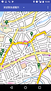
Search and display evacuation centers and routes near your current location.
When searching, you can specify "designated evacuation shelter" "Tsunami emergency shelter".
Other evacuation centers are also displayed, so you can choose your own shelter according to the actual situation.
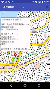
You can display detailed information by tapping the evacuation center marker on the map.
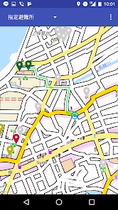
You can display the route to the evacuation center by long-pressing the marker of the shelter on the map.
Even if the current position changes, the route once searched is not automatically updated. If you want to update, you can update by pressing the search button.
Also, because we are using offline maps, even if we can not use the Internet due to disasters etc, it works without problems.
* This application is not official application of Ise city.
The evacuation center data used in this application is modified by modifying the following works.
· "Designated evacuation place at disaster", Ise city, Creative Commons · License display 2. 1 Japan
http://creativecommons.org/licenses/by/2.1/jp/
This application uses the following open data.
· OpenStreetMap, ODbL
When searching, you can specify "designated evacuation shelter" "Tsunami emergency shelter".
Other evacuation centers are also displayed, so you can choose your own shelter according to the actual situation.
You can display detailed information by tapping the evacuation center marker on the map.
You can display the route to the evacuation center by long-pressing the marker of the shelter on the map.
Even if the current position changes, the route once searched is not automatically updated. If you want to update, you can update by pressing the search button.
Also, because we are using offline maps, even if we can not use the Internet due to disasters etc, it works without problems.
* This application is not official application of Ise city.
The evacuation center data used in this application is modified by modifying the following works.
· "Designated evacuation place at disaster", Ise city, Creative Commons · License display 2. 1 Japan
http://creativecommons.org/licenses/by/2.1/jp/
This application uses the following open data.
· OpenStreetMap, ODbL
Updated on
Safety starts with understanding how developers collect and share your data. Data privacy and security practices may vary based on your use, region, and age. The developer provided this information and may update it over time.

No data shared with third parties
Learn more about how developers declare sharing

No data collected
Learn more about how developers declare collection
What’s new
・伊勢市の避難所データのフォーマット変更へ対応
・デフォルトの避難所データおよびマップデータを2024年11 月現在のものに更新
・デフォルトの避難所データおよびマップデータを2024年11 月現在のものに更新
App support
About the developer
MORI SOFT
inquery.app.morisoft@gmail.com
172, KO, TAJIRICHO
ISE, 三重県 516-0006
Japan
+81 50-3628-5091