SkyCharts XC EFB geo-reference
Enthält Werbung
3.5star
89 Rezensionen
10 Tsg.+
Downloads

Jedes Alter
info
Über diese App
Current and valid FAA&AISWEB aviation charts updated every 28 days, including approach plates! Includes basic international airport data from ourairports.net and openAIP.net.
Due to no freely avialable charts, please note that for charts outside of USA&Brazil non current ONC/VFR with a current openAIP overlay is available, but NO IFR charts or plates are available.
Includes a free 30 day trial!
If you wish to continue using SkyCharts after the trial, please purchase a $3.99/month subscription. Note that buying a subscription does not unlock any additional features.
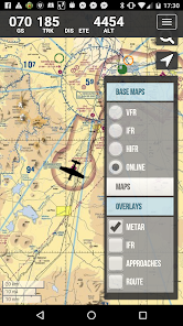
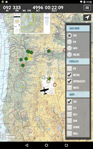
For USA/Alaska, the application has all current FAA VFR (sectional+WAC), IFR (High and Low), TAC, FLY (flip side of TAC chart), Helicopter, Gulf Coast WAC, Gulf Of Mexico, and Wall aviation charts.
Grand Canyon charts are included in the TAC charts, and Bahamas and Mexico as WAC charts.
Brazil has VFR, IFR (High and Low) and approach plates.
Also included is a METAR/TAF overlay, and an IFR overlay to view routes on top of VFR charts.
Its very easy to create and modify routes directly on the map or by drag&drop in table.
Navigation readout is configurable to fit exactly what you want to see. It also has a nifty auto-layout feature that selects fields for you in both portrait and landscape mode.
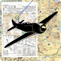
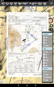
DOUBLE TAP on map to view A/FD and approach plates.
Map has VFR/IFR/LIFR color-coded weather METARs, with orange TAFs.
SUA (Special Use Airspace) information is also available.
Download charts and plates for offline usage.
Features:
* Fast zoom/scroll of included charts using standard gestures.
* Allows download of charts for offline usage. Charts are selected on a region basis.
* Navigation computes GS, TRK, DTK, DIS & ETE to final waypoint.
* METAR/TAF color coded dots according to ADDS: http://www.skycharts.net/?page_id=421
* Double tap on airport to select A/FD and TPPs/IAPs to view.
* Huge built-in navigation database, with all 20,000 airports, 45,000 FAA IFR/VFR navigation fixes and 2,100 FAA VOR/ADF fixes.
For more information, please see the webpage at
http://www.skycharts.net
The monthly subscription of SkyCharts XC aviation data of $3.99 is auto-renewed. Payment will be charged to your Google Play Store account at confirmation of purchase. You can turn off auto-renew at any time from your Google Play Store account settings, but you must do so at least 24 hours before the end of the current subscription period to avoid being billed for the next cycle. No cancellation of the current subscription is allowed during the active period. Any unused portion of a free trial period will be forfeited when you purchase a subscription to SkyCharts XC.
The privacy policy and EULA can be found here:
http://www.skycharts.net/?page_id=1465
For fast response to all questions, comments or suggestions, please email support@skycharts.net
Due to no freely avialable charts, please note that for charts outside of USA&Brazil non current ONC/VFR with a current openAIP overlay is available, but NO IFR charts or plates are available.
Includes a free 30 day trial!
If you wish to continue using SkyCharts after the trial, please purchase a $3.99/month subscription. Note that buying a subscription does not unlock any additional features.
For USA/Alaska, the application has all current FAA VFR (sectional+WAC), IFR (High and Low), TAC, FLY (flip side of TAC chart), Helicopter, Gulf Coast WAC, Gulf Of Mexico, and Wall aviation charts.
Grand Canyon charts are included in the TAC charts, and Bahamas and Mexico as WAC charts.
Brazil has VFR, IFR (High and Low) and approach plates.
Also included is a METAR/TAF overlay, and an IFR overlay to view routes on top of VFR charts.
Its very easy to create and modify routes directly on the map or by drag&drop in table.
Navigation readout is configurable to fit exactly what you want to see. It also has a nifty auto-layout feature that selects fields for you in both portrait and landscape mode.
DOUBLE TAP on map to view A/FD and approach plates.
Map has VFR/IFR/LIFR color-coded weather METARs, with orange TAFs.
SUA (Special Use Airspace) information is also available.
Download charts and plates for offline usage.
Features:
* Fast zoom/scroll of included charts using standard gestures.
* Allows download of charts for offline usage. Charts are selected on a region basis.
* Navigation computes GS, TRK, DTK, DIS & ETE to final waypoint.
* METAR/TAF color coded dots according to ADDS: http://www.skycharts.net/?page_id=421
* Double tap on airport to select A/FD and TPPs/IAPs to view.
* Huge built-in navigation database, with all 20,000 airports, 45,000 FAA IFR/VFR navigation fixes and 2,100 FAA VOR/ADF fixes.
For more information, please see the webpage at
http://www.skycharts.net
The monthly subscription of SkyCharts XC aviation data of $3.99 is auto-renewed. Payment will be charged to your Google Play Store account at confirmation of purchase. You can turn off auto-renew at any time from your Google Play Store account settings, but you must do so at least 24 hours before the end of the current subscription period to avoid being billed for the next cycle. No cancellation of the current subscription is allowed during the active period. Any unused portion of a free trial period will be forfeited when you purchase a subscription to SkyCharts XC.
The privacy policy and EULA can be found here:
http://www.skycharts.net/?page_id=1465
For fast response to all questions, comments or suggestions, please email support@skycharts.net
Aktualisiert am
Was die Sicherheit angeht, solltest du als Erstes verstehen, wie Entwickler deine Daten erheben und weitergeben. Die Datenschutz- und Sicherheitspraktiken können je nach deiner Verwendung, deiner Region und deinem Alter variieren. Diese Informationen wurden vom Entwickler zur Verfügung gestellt und können jederzeit von ihm geändert werden.

Keine Daten werden mit Drittunternehmen oder -organisationen geteilt

Diese App kann die folgenden Datentypen erheben
Personenbezogene Daten

Daten werden nicht verschlüsselt
Daten können nicht gelöscht werden
Bewertungen und Rezensionen
4.5
68 Rezensionen
Neuerungen
2510 database
Updated libraries
Updated libraries
Support für diese App
Informationen zum Entwickler
SKYCHARTS LLC
heikki.julkunen@gmail.com
1309 SE 32nd Pl
Portland, OR 97214
United States
+1 512-731-9581


