Кадастровая карта России
10K+
Downloads

Everyone
info

About this app
Application "Public Cadastral Map" - access to reliable and most relevant information stored in the real estate registry and the cadastral chamber.
With the app, you can get the following information:
• cadastral number;
• official address;
• the area of the land plot;
• purpose of the site (type of permitted use);
• cost according to official government estimates.
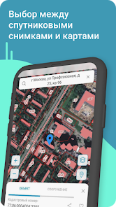
The public cadastral map of Russia covers all areas located on the territory of the Russian Federation. In online mode, the user can see information on the sites of all 85 subjects of the country. The information on the Rosreestr map is open, up-to-date, constantly updated. Online cadastral map of Russia is easy to use. The necessary information is provided instantly and includes the data of all sites on the territory of the country, registered in Rosreestr.
The map allows you to find out the exact area of the site, the date of registration, land boundaries, area and registered rights. In addition, the user receives information about the administrative division of the country, the location of the object, the department of the register to which the land belongs. The boundaries of the plot, the adjacent lands entered in the register are indicated. Each object can be viewed on a satellite image and on a detailed digital topographic map. The cadastral map of Russia allows you to check the accuracy of the cadastral number if the applicant knows the address of the object. In addition, the resource helps determine the value of a piece of land. Get information about the property by its address or cadastral number.
How to determine the cadastral number?
The cadastral number is a set of numbers assigned to a land plot depending on its location. It is easy to determine if you know the exact address of the object. It is not difficult to do this on the map. By entering the cadastral number in the search line on the map, the applicant receives data on the exact area, address of the site, cadastral value, status, date of registration, form of ownership and other characteristics.
When is the card needed?
The resource is often used by real estate buyers, realtors, surveyors, lawyers, etc. The cadastral map is recommended for use before buying or selling a land plot. The buyer can navigate by the market value of the site, knowing its price according to the cadastral valuation. In addition, the user will be able to find out how much tax he will have to pay in the future, because it is calculated depending on the cadastral value of the site.
How to use the card?
To find out information about a specific object, you must indicate its cadastral number. After that, the desired site will be found and the user is provided with all the available information about the object. If the cadastral number is unknown, you must enter the address of the site.
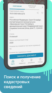
You cannot order an extract from the USRN in the application. But you can get a comprehensive report on the property.
Types of reports:
- about the main characteristics (number, address, area, information about the owners, date of registration of the right);
- on the transfer of rights to property (indicating data on the current and previous owners).
To obtain information, just select a site or building on the map or drive in a cadastral number.
A real estate report from the USRN is required for the implementation of any real estate transactions.
With the app, you can get the following information:
• cadastral number;
• official address;
• the area of the land plot;
• purpose of the site (type of permitted use);
• cost according to official government estimates.
The public cadastral map of Russia covers all areas located on the territory of the Russian Federation. In online mode, the user can see information on the sites of all 85 subjects of the country. The information on the Rosreestr map is open, up-to-date, constantly updated. Online cadastral map of Russia is easy to use. The necessary information is provided instantly and includes the data of all sites on the territory of the country, registered in Rosreestr.
The map allows you to find out the exact area of the site, the date of registration, land boundaries, area and registered rights. In addition, the user receives information about the administrative division of the country, the location of the object, the department of the register to which the land belongs. The boundaries of the plot, the adjacent lands entered in the register are indicated. Each object can be viewed on a satellite image and on a detailed digital topographic map. The cadastral map of Russia allows you to check the accuracy of the cadastral number if the applicant knows the address of the object. In addition, the resource helps determine the value of a piece of land. Get information about the property by its address or cadastral number.
How to determine the cadastral number?
The cadastral number is a set of numbers assigned to a land plot depending on its location. It is easy to determine if you know the exact address of the object. It is not difficult to do this on the map. By entering the cadastral number in the search line on the map, the applicant receives data on the exact area, address of the site, cadastral value, status, date of registration, form of ownership and other characteristics.
When is the card needed?
The resource is often used by real estate buyers, realtors, surveyors, lawyers, etc. The cadastral map is recommended for use before buying or selling a land plot. The buyer can navigate by the market value of the site, knowing its price according to the cadastral valuation. In addition, the user will be able to find out how much tax he will have to pay in the future, because it is calculated depending on the cadastral value of the site.
How to use the card?
To find out information about a specific object, you must indicate its cadastral number. After that, the desired site will be found and the user is provided with all the available information about the object. If the cadastral number is unknown, you must enter the address of the site.
You cannot order an extract from the USRN in the application. But you can get a comprehensive report on the property.
Types of reports:
- about the main characteristics (number, address, area, information about the owners, date of registration of the right);
- on the transfer of rights to property (indicating data on the current and previous owners).
To obtain information, just select a site or building on the map or drive in a cadastral number.
A real estate report from the USRN is required for the implementation of any real estate transactions.
Updated on
Safety starts with understanding how developers collect and share your data. Data privacy and security practices may vary based on your use, region, and age. The developer provided this information and may update it over time.

No data shared with third parties
Learn more about how developers declare sharing

This app may collect these data types
Device or other IDs

Data is encrypted in transit
What's new
Публичная кадастровая карта России. Проверка и оплата имущественного налога


