
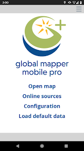
Global Mapper Mobile
3.7star
385 reviews
100K+
Downloads

Everyone
info

About this app
Global Mapper Mobile
Bring your GIS workflow to the field.
Global Mapper Mobile® is a powerful Android application for viewing and collecting GIS data. It utilizes the GPS capabilities of mobile devices to provide situational awareness and locational intelligence for remote mapping projects. A perfect complement to the desktop version of Global Mapper, the mobile app provides maps-in-hand functionality for engineers, surveyors, wildlife managers, foresters, and anyone whose job requires access to spatial data in remote locations.
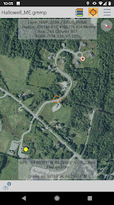
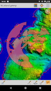
Global Mapper Mobile can display vector, raster, and elevation data layers that have been transferred from the desktop version of the software. It also provides tools for drawing, tracking, and form-based data collection using pre-configured attributes and picklists.
Global Mapper Mobile Base Version (Free)
The base version of Global Mapper Mobile is free of charge and provides an array of features and functions, including:
• Vector, raster, and terrain data display
• GPS location display
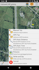
• Point, line, and polygon feature creation using GPS location
• Editing of existing vector features
• Capture of images in the field
• Creation of Picture Points from geotagged images
• Attribute and feature notation recording for new or existing vector features
• Online access to Open Street Map data
Global Mapper Mobile Pro
The Pro version of Global Mapper Mobile, available as an in-app purchase, supplements the functionality of the base version with an array of professional-grade tools, including:
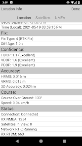
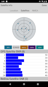
• Advanced GPS support for connection to high-accuracy GNSS devices from vendors such as Bad Elf, EOS, Juniper, and others
• RTK correction via built-in NTRIP client
• GPS Averaging
• Terrain shader and water level display options
• Custom online source options and online data saving for offline use
• Simultaneous feature creation
• Viewshed creation
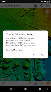
• Volume calculation
• Data reprojection
• Address searching
• Geopackage and GeoPDF format support
Global Mapper Mobile Pro is available for purchase from the Blue Marble Geographics website. The license is based on an annual subscription from the date of purchase that can be renewed each year. Enterprise licensing options are also available. For more information, email orders@bluemarblegeo.com.
Note: Continued use of GPS running in the background can dramatically decrease battery life.
Privacy Policy:
https://www.bluemarblegeo.com/privacy-policy/
Terms of Use:
https://www.bluemarblegeo.com/licensing-policy/
Bring your GIS workflow to the field.
Global Mapper Mobile® is a powerful Android application for viewing and collecting GIS data. It utilizes the GPS capabilities of mobile devices to provide situational awareness and locational intelligence for remote mapping projects. A perfect complement to the desktop version of Global Mapper, the mobile app provides maps-in-hand functionality for engineers, surveyors, wildlife managers, foresters, and anyone whose job requires access to spatial data in remote locations.
Global Mapper Mobile can display vector, raster, and elevation data layers that have been transferred from the desktop version of the software. It also provides tools for drawing, tracking, and form-based data collection using pre-configured attributes and picklists.
Global Mapper Mobile Base Version (Free)
The base version of Global Mapper Mobile is free of charge and provides an array of features and functions, including:
• Vector, raster, and terrain data display
• GPS location display
• Point, line, and polygon feature creation using GPS location
• Editing of existing vector features
• Capture of images in the field
• Creation of Picture Points from geotagged images
• Attribute and feature notation recording for new or existing vector features
• Online access to Open Street Map data
Global Mapper Mobile Pro
The Pro version of Global Mapper Mobile, available as an in-app purchase, supplements the functionality of the base version with an array of professional-grade tools, including:
• Advanced GPS support for connection to high-accuracy GNSS devices from vendors such as Bad Elf, EOS, Juniper, and others
• RTK correction via built-in NTRIP client
• GPS Averaging
• Terrain shader and water level display options
• Custom online source options and online data saving for offline use
• Simultaneous feature creation
• Viewshed creation
• Volume calculation
• Data reprojection
• Address searching
• Geopackage and GeoPDF format support
Global Mapper Mobile Pro is available for purchase from the Blue Marble Geographics website. The license is based on an annual subscription from the date of purchase that can be renewed each year. Enterprise licensing options are also available. For more information, email orders@bluemarblegeo.com.
Note: Continued use of GPS running in the background can dramatically decrease battery life.
Privacy Policy:
https://www.bluemarblegeo.com/privacy-policy/
Terms of Use:
https://www.bluemarblegeo.com/licensing-policy/
Updated on
Safety starts with understanding how developers collect and share your data. Data privacy and security practices may vary based on your use, region, and age. The developer provided this information and may update it over time.

No data shared with third parties
Learn more about how developers declare sharing

This app may collect these data types
App activity, App info and performance, and Device or other IDs

Data is encrypted in transit

You can request that data be deleted
Ratings and reviews
3.7
367 reviews

Brian Muraba
- Flag inappropriate
September 4, 2020
I'm using the free version and I really love it , a mobile GIS software where I'm able to load high resolution aerial imagery, shape files, etc , packaged as global mobile mobile package files from the desktop version, then actively navigating with all the data loaded as background. One can also pick data in the field and visualize it right on the phone. Excellent. How much does it cost to get the paid version of global mapper mobile?
30 people found this review helpful

A Google user
- Flag inappropriate
November 12, 2019
It is nice to access to your data on field , but I am disappointed, the app is to slow to responds and some time will crash when I update may date , it's not as good as PC's Edition even not about 10%. Hope it will be more responsive in the future.
21 people found this review helpful

D K
- Flag inappropriate
June 27, 2020
An excellent start for those that use global mapper desktop. We have started to deploy in the field and it is a great way to allow people to take a full global mapper project with them. I am sure as more features are rolled into the app it will become better and better
19 people found this review helpful
What's new
Standard (free):
- Raster Info tool
- Digitizer trace mode
- Improved vector, raster, and terrain data render speed
- Dark Theme improvements
- Fix file import issue on Android 13
Pro Subscription:
- Support for viewshed calculation from current GPS location
- Save viewshed point and create viewshed area features
- Expanded volume calculation options to include pile volume and vertex elevation
- Added support for Trimble GNSS devices