

MAGMA Indonesia

4.6star
2.09K reviews
100K+
Downloads

Everyone
info

About this app
MAGMA Indonesia is an application that presents information and recommendations, as quasi real-time regarding geological disaster in Indonesia including Volcano, Land Movement, Earthquake and Tsunami. This application is developed independently by PNS Development Team at the Center for Volcanology and Geological Hazard Mitigation, Geological Agency, Ministry of Energy and Mineral Resources. MAGMA Indonesia was built to serve the people of Indonesia and the international community. MAGMA Indonesia is a newly developed breakthrough Indonesia in the context of geological disaster mitigation efforts.
Features information:
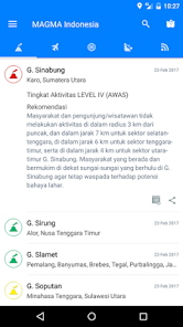
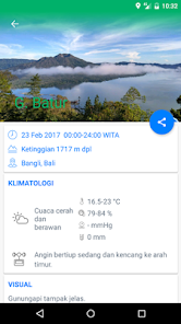
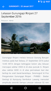
1. Information Volcano Activity (Volcanic Activity Report / VAR). This information is an early warning system for volcanic processed from the data reporting routine Observer Volcano and staff Mitigation of Volcanic Indonesia into information such as location maps, basic data, the data on visual observations and instrumental, the status of the activity level, recommendations for the residents and visitors who move around volcanoes, the name of the report's authors and source data.
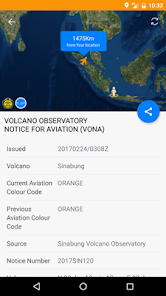
2. Information Eruption / Volcanic Ash to Flight (Volcano Observatory Notice for Aviation / Vona). This information is an early warning system for volcanoes to flight safety (national / international) which passes through the territory of Indonesia contains information map location and time of occurrence explosion / blast of volcanic ash, the color code (the alert level), the height of the eruption column, the direction of the spread of volcanic ash, authorship reports and data sources.
3. Information status volcanic activity levels overall.
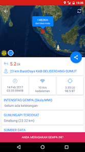
4. Information and Response Earthquake / Tsunami (On Earthquake Response / ROQ) which presents the basic information such as a map of the location and time of occurrence, magnitude, depth, a symbol of the earthquake mechanism in the vicinity of an earthquake, the name of a nearby volcano and earthquake epicenter data sources. Other information that can be provided (but not always) in the form of earthquake intensity (MMI) and the response contains a description, condition of the area, mechanism, impact, and the name of the report's recommendations.
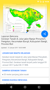
5. Information and Land Movement incident response / Avalanche (mitigation of ground movement / SIGERTAN) containing information on a map location and time of occurrence, impact, conditions of the affected areas, the condition of the soil movement, appearance / dimensions, causes, recommendations authorship of reports and sources data.
6. Press Release (Press Release). Geological disaster information presented in list form.
7. Search the name of the location of geological disasters.
8. Disaster Prone Areas Map Download Volcano, Earthquake and Tsunami and Vulnerability Zone Map and Map Potential Land Movement.
Interactive features:
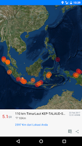
1. Map of geological disasters which displays the distribution of site types of geological disasters including information include the distance between the position measuring algorithm Users with geological disaster site.
2. Disaster Report (Community Reporting System). Media for the public to report geological disasters in the vicinity as well as derived from information / news reliable.
3. Report of earthquakes were felt (Report of earthquake intensity / LINE). Media for the public to report earthquakes are felt.
4. Geological Disaster Notification settings. Users can set the desired geological disaster notification in accordance with the hazard potential in the region.
Source of data used MAGMA Indonesia applications:
1. Center for Volcanology and Geological Hazard Mitigation (PVMBG), Geological Agency, Ministry of Energy and Mineral Resources (Baseline Data and Report Response)
2. Meteorology and Geophysics (Location Earthquakes)
3. The United States Geological Survey (Location Earthquakes)
4. Deutsches GeoForschungsZentrum (Location Earthquakes)
5. Global Centroid Moment Tensor (Mechanisms Earthquakes)
6. Smithsonian Institution, Global Volcanism Program (Baseline)
7. Open Street Map (Basemap)
8. ESRI Mapserver (Basemap)
Appreciation:
2016 - The Ministry of Energy and Mineral Resources Innovation Award # 1 Best Application
2017 - Top 99 RB Kemenpan Public Service Innovation
Features information:
1. Information Volcano Activity (Volcanic Activity Report / VAR). This information is an early warning system for volcanic processed from the data reporting routine Observer Volcano and staff Mitigation of Volcanic Indonesia into information such as location maps, basic data, the data on visual observations and instrumental, the status of the activity level, recommendations for the residents and visitors who move around volcanoes, the name of the report's authors and source data.
2. Information Eruption / Volcanic Ash to Flight (Volcano Observatory Notice for Aviation / Vona). This information is an early warning system for volcanoes to flight safety (national / international) which passes through the territory of Indonesia contains information map location and time of occurrence explosion / blast of volcanic ash, the color code (the alert level), the height of the eruption column, the direction of the spread of volcanic ash, authorship reports and data sources.
3. Information status volcanic activity levels overall.
4. Information and Response Earthquake / Tsunami (On Earthquake Response / ROQ) which presents the basic information such as a map of the location and time of occurrence, magnitude, depth, a symbol of the earthquake mechanism in the vicinity of an earthquake, the name of a nearby volcano and earthquake epicenter data sources. Other information that can be provided (but not always) in the form of earthquake intensity (MMI) and the response contains a description, condition of the area, mechanism, impact, and the name of the report's recommendations.
5. Information and Land Movement incident response / Avalanche (mitigation of ground movement / SIGERTAN) containing information on a map location and time of occurrence, impact, conditions of the affected areas, the condition of the soil movement, appearance / dimensions, causes, recommendations authorship of reports and sources data.
6. Press Release (Press Release). Geological disaster information presented in list form.
7. Search the name of the location of geological disasters.
8. Disaster Prone Areas Map Download Volcano, Earthquake and Tsunami and Vulnerability Zone Map and Map Potential Land Movement.
Interactive features:
1. Map of geological disasters which displays the distribution of site types of geological disasters including information include the distance between the position measuring algorithm Users with geological disaster site.
2. Disaster Report (Community Reporting System). Media for the public to report geological disasters in the vicinity as well as derived from information / news reliable.
3. Report of earthquakes were felt (Report of earthquake intensity / LINE). Media for the public to report earthquakes are felt.
4. Geological Disaster Notification settings. Users can set the desired geological disaster notification in accordance with the hazard potential in the region.
Source of data used MAGMA Indonesia applications:
1. Center for Volcanology and Geological Hazard Mitigation (PVMBG), Geological Agency, Ministry of Energy and Mineral Resources (Baseline Data and Report Response)
2. Meteorology and Geophysics (Location Earthquakes)
3. The United States Geological Survey (Location Earthquakes)
4. Deutsches GeoForschungsZentrum (Location Earthquakes)
5. Global Centroid Moment Tensor (Mechanisms Earthquakes)
6. Smithsonian Institution, Global Volcanism Program (Baseline)
7. Open Street Map (Basemap)
8. ESRI Mapserver (Basemap)
Appreciation:
2016 - The Ministry of Energy and Mineral Resources Innovation Award # 1 Best Application
2017 - Top 99 RB Kemenpan Public Service Innovation
Updated on
Data safety
Developers can show information here about how their app collects and uses your data. Learn more about data safety

No information available