
BaseMap: Hunting Maps and GPS
In-app purchases
4.3star
4.22K reviews
500K+
Downloads

Everyone
info
About this app
Precision land ownership maps and industry leading GPS tools for hunters and outdoorsmen.
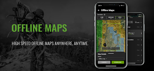
OFFLINE GPS and TRACKING
• Cache maps for offline use without service.
• Save as many offline maps as you want with unlimited caching (Pro).
• Know exactly where you are in real time even without cellular coverage.
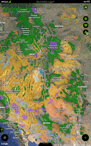
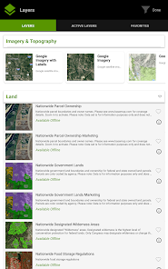
MAP LAYERS
• Over 800 layers and growing
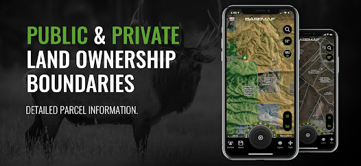
• Nationwide Color Coded Govt Lands
• Nationwide Private Parcel Boundaries & Owner Names
• Water depths for East coast, West, Coast, Gulf coast, & over 4,000 U.S. lakes
• Nationwide Hiking Trails
• Nationwide Wildfires & Timbercuts
• Nationwide Wilderness & Roadless Areas
• State specific hunting layers including hunting unit boundaries, private hunting opportunities, WMA’s & more
• Multiple Topography & Satellite Imagery basemap options
• Much more
LRF MAPPING (Laser Rangefinder Mapping)
• Use your rangefinder as a powerful mapping tool
• Precisely mark the exact location of distant targets with ANY rangefinder
• Recover game, build routes, plan stalks, lookup distant property owners and more, all using your rangefinder!
MOBILE GPS
• Know your exact location even without cellular or WiFi service
• See where you are in relation to property boundaries, roads, trails, peaks, or boundaries
• Navigate to trail heads, favorite places, markers, or anything you need to locate with our powerful Search and GoTo features.
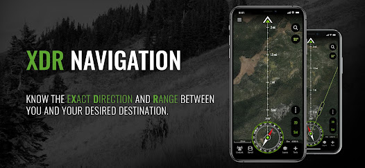
XDR (Exact Direction & Range) NAVIGATION TOOL
• Easy Point and Go navigation
• Know the exact distance between you and your destination.
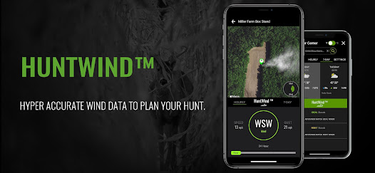
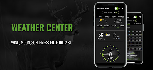
HUNTWIND™ & WEATHER CENTER
• Wind forecast to better plan your hunt.
• Know the exact day and time to hunt a particular stand and visualize wind direction and scent drift in relation to your location.
• Forecasts, temperature, moon phase, sunrise/sunset, wind, and more.
LOCATION SHARING
• Know exactly where your hunting partner is located
• Real-time updates
OUTDOOR JOURNAL
• Capture, log, and share all your outdoor adventures with the BaseMap community
• Real-time location sharing so friends can see where you are in case of emergency (connection reqd.)
• SmartMarkers - Automatically capture the weather conditions at the time you add a marker.
HARVEST LOG
• Log your hunts as detailed as you'd like. Record your hunt type, species/size, weapon, unit/GMU & much more.
GEARDROP
• Drop your marker closest to the GearDrop marker & win free gear.
GOOGLE EARTH INTEGRATION
• Export markers and view them right in Google Earth
• View the terrain in true 3D
DESKTOP APPLICATION
• Automatically sync all your data between your phone and the BaseMap web application.
SUBSCRIPTIONS
BASIC (Free)
• No Ads
• Connect with friends
• Hybrid 3D Imagery (map tilt).
• XDR Navigation
• Nationwide Roads, Trails & Points of Interest
• Nationwide Lakes, Rivers & Streams
• Hunting Unit boundaries
• GPS Location & Tracking
• Hi-Res Satellite Imagery
PRO ($34.99/yr)
• Everything in Basic plan
• Access to over 800 Layers
• Unlimited Data & Offline Use
• Nationwide parcel boundaries and owner names
• Nationwide color-coded government lands
• Google Earth Integration
• Import/Export KML and GPX with BaseMap web application
• Real-Time location sharing
• LRF Mapping (Laser Rangefinder Mapping)
PRO BUNDLE ($69.99/yr)
Includes:
• BaseMap Pro subscription
• HuntScore subscription for draw odds, harvest data, application tools, and more
• Global Rescue subscription for field advisory and rescue services
• $175 value
For questions or more information, contact us at: support@basemap.com
Privacy policy: https://www.basemap.com/privacy-policy/
Terms of use: https://www.basemap.com/terms-of-use/
OFFLINE GPS and TRACKING
• Cache maps for offline use without service.
• Save as many offline maps as you want with unlimited caching (Pro).
• Know exactly where you are in real time even without cellular coverage.
MAP LAYERS
• Over 800 layers and growing
• Nationwide Color Coded Govt Lands
• Nationwide Private Parcel Boundaries & Owner Names
• Water depths for East coast, West, Coast, Gulf coast, & over 4,000 U.S. lakes
• Nationwide Hiking Trails
• Nationwide Wildfires & Timbercuts
• Nationwide Wilderness & Roadless Areas
• State specific hunting layers including hunting unit boundaries, private hunting opportunities, WMA’s & more
• Multiple Topography & Satellite Imagery basemap options
• Much more
LRF MAPPING (Laser Rangefinder Mapping)
• Use your rangefinder as a powerful mapping tool
• Precisely mark the exact location of distant targets with ANY rangefinder
• Recover game, build routes, plan stalks, lookup distant property owners and more, all using your rangefinder!
MOBILE GPS
• Know your exact location even without cellular or WiFi service
• See where you are in relation to property boundaries, roads, trails, peaks, or boundaries
• Navigate to trail heads, favorite places, markers, or anything you need to locate with our powerful Search and GoTo features.
XDR (Exact Direction & Range) NAVIGATION TOOL
• Easy Point and Go navigation
• Know the exact distance between you and your destination.
HUNTWIND™ & WEATHER CENTER
• Wind forecast to better plan your hunt.
• Know the exact day and time to hunt a particular stand and visualize wind direction and scent drift in relation to your location.
• Forecasts, temperature, moon phase, sunrise/sunset, wind, and more.
LOCATION SHARING
• Know exactly where your hunting partner is located
• Real-time updates
OUTDOOR JOURNAL
• Capture, log, and share all your outdoor adventures with the BaseMap community
• Real-time location sharing so friends can see where you are in case of emergency (connection reqd.)
• SmartMarkers - Automatically capture the weather conditions at the time you add a marker.
HARVEST LOG
• Log your hunts as detailed as you'd like. Record your hunt type, species/size, weapon, unit/GMU & much more.
GEARDROP
• Drop your marker closest to the GearDrop marker & win free gear.
GOOGLE EARTH INTEGRATION
• Export markers and view them right in Google Earth
• View the terrain in true 3D
DESKTOP APPLICATION
• Automatically sync all your data between your phone and the BaseMap web application.
SUBSCRIPTIONS
BASIC (Free)
• No Ads
• Connect with friends
• Hybrid 3D Imagery (map tilt).
• XDR Navigation
• Nationwide Roads, Trails & Points of Interest
• Nationwide Lakes, Rivers & Streams
• Hunting Unit boundaries
• GPS Location & Tracking
• Hi-Res Satellite Imagery
PRO ($34.99/yr)
• Everything in Basic plan
• Access to over 800 Layers
• Unlimited Data & Offline Use
• Nationwide parcel boundaries and owner names
• Nationwide color-coded government lands
• Google Earth Integration
• Import/Export KML and GPX with BaseMap web application
• Real-Time location sharing
• LRF Mapping (Laser Rangefinder Mapping)
PRO BUNDLE ($69.99/yr)
Includes:
• BaseMap Pro subscription
• HuntScore subscription for draw odds, harvest data, application tools, and more
• Global Rescue subscription for field advisory and rescue services
• $175 value
For questions or more information, contact us at: support@basemap.com
Privacy policy: https://www.basemap.com/privacy-policy/
Terms of use: https://www.basemap.com/terms-of-use/
Updated on
Safety starts with understanding how developers collect and share your data. Data privacy and security practices may vary based on your use, region, and age. The developer provided this information and may update it over time.

No data shared with third parties
Learn more about how developers declare sharing

This app may collect these data types
Location, Personal info and 2 others

Data is encrypted in transit

You can request that data be deleted
Ratings and reviews
4.3
4.1K reviews

April Mack
- Flag inappropriate
March 18, 2024
This App is awful, I have had nothing but problems with it for the past year, the property owner information for Oregon has yet to be updated (was told it would update in January), and my app constantly crashes. Half of the time I can't even get the app to open, and when/if it finally does, it crashes half way through while looking at it. The road labels are the same as google maps, the FS roads are not listed. Many other issues! It started off great, but has turned into a nightmare.

Christopher Maley
- Flag inappropriate
January 31, 2024
Multi year user, had been satisfied given the price compared to competitors until this past fall. At the end of October, all of my colored markers which i used strategically to mark different items (stands, water, food) changed to the default green tent logo in the middle of PAs Rut. Support was quick to respond but that's about the extent of their help. They basically confirmed that the data in their system had changed but couldnt explain or fix it. Had to manually "fix" hundreds of markers.
1 person found this review helpful

Wayne
- Flag inappropriate
March 9, 2024
If you are looking for a really good hunting app, this is it ! I have the other popular hunting apps on my phone, but Basemap is the only one I use now. This app stays up to date better than the others. I pulled up the satellite on all 4 of the apps and basemap was the only one that had the current aerial photos of my farm and the other 3 apps were all at least 3 months behind on the aerial/satellite photos of my farm. I know this as fact because of where my vehicles and tractors were parked.
2 people found this review helpful
What's new
In this update we made improvements to BaseMap Connect and Bluetooth connections with compatible devices.


