Navitel Navigator 11 is a precise offline GPS navigation, up-to-date online services, and detailed maps of 67 countries and territories of the world. 7 days free.
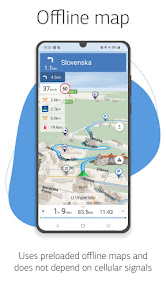
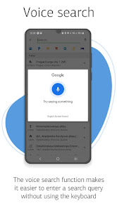
ADVANTAGES • Modern user-friendly interface • Offline maps. To work with the program and maps, you do not need the Internet: savings in roaming and independence from the quality of communication in the regions • Navigation maps with a high level of detail • Voice search • Easy and convenient POI search by category • Visual and voice guidance along the route • Actual information about road warnings, potentially dangerous places, speed cameras, road restrictions, etc. • HUD (Head-Up Display) • Detailed navigation maps of 67 countries and territories of the world are available for purchase.
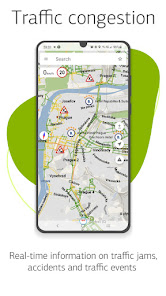
SPECIAL FEATURES • Fast route calculation. Instant calculation and routing of any length and complexity. • 3 alternative routes with distance and travel time information. • Navitel.Traffic. Information on all traffic jams in the covered area, available in real-time. • Navitel.Events. Road accidents, road works, speed cams, and other events marked on the map by users. • SpeedCam warnings. Information on radars, video recording cameras, and speed bumps. • 3D Mapping. Three-dimensional maps with texture and number of floors support. • 3D Road interchanges. Displaying multilevel road interchanges in 3D mode. • Lane Assist. Route calculations taking multilane traffic into account and visual prompts while following the route • Turn-by-turn voice guidance while moving along the route. • Cargo graph: building routes considering road signs for cars from 3.5 - 20 tons, with the ability to customize the parameters of your vehicle and get a route that is relevant for a particular truck. • Dynamic POI. Fuel prices, movies showtimes, and other useful information. • Unlimited number of waypoints when building a route. Convenient route planning with an unlimited number of waypoints. • Multilanguage. Support for interface and voice prompts in 39 languages. • Customizable user interface. Ability to adapt the program interface and map display mode for your own needs. • Purchases from the program menu. Purchase of new packs of maps and renewal of those already purchased from the main menu. • Multitouch support. Quick access to map scaling and rotation functions via the multitouch input. • Support for two navigation systems - GLONASS and GPS.
If you have any questions contact us: support@navitel.cz. We will be happy to help you.
Updated on
Jun 13, 2023
Maps & Navigation
Data safety
arrow_forward
Safety starts with understanding how developers collect and share your data. Data privacy and security practices may vary based on your use, region, and age. The developer provided this information and may update it over time.