
notams.aero
In-app purchases
10K+
Downloads

Everyone
info


About this app
Notams Aero is the best NOTAM application.
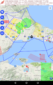
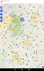
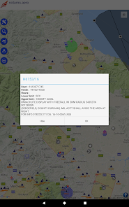
You can see NOTAMs on the map. Each NOTAM is displayed in categorized colors. Red means firing, yellow means training, blue means UAV, green means parachute etc. Additionally; each NOTAM area has a symbol which describes its subject ( for instance; you will see a remote control symbol for UAV NOTAM area)
* Flight recording and exporting of this as KML file
* Airport/Aerodrome meteorological information (METAR & TAF)
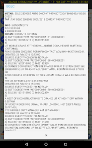
* Airport/Aerodrome NOTAMs
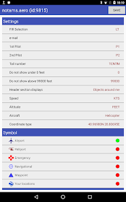
* Altitude filtering for NOTAMs
* All defined areas (prohibited areas, restricted areas, CTR, TMA etc)
* Airports, heliports and other aeronautical points with their detailed information
notams.aero contains these countries :
Albania, Armenia, Austria, Belgium, Bosnia, Bulgaria, Croatia, Cyprus, Czech Republic, Denmark, Estonia, Georgia, Germany, Greece, Finland, France, Hungary, Ireland, Italy, Latvia, Lithuania, Luxemburg, Macedonia, Malta, Moldova, Netherlands, Norway, Poland, Portugal, Romania, Serbia, Slovakia, Slovenia, Spain, Sweden, Switzerland, Ukraine, United Kingdom and United States
notams.aero is NOT FREE. You should purchase annual subscription to have all information.
For more information, privacy policy and terms of use please visit : http://notamtr.com/eu_policy.aspx
You can see NOTAMs on the map. Each NOTAM is displayed in categorized colors. Red means firing, yellow means training, blue means UAV, green means parachute etc. Additionally; each NOTAM area has a symbol which describes its subject ( for instance; you will see a remote control symbol for UAV NOTAM area)
* Flight recording and exporting of this as KML file
* Airport/Aerodrome meteorological information (METAR & TAF)
* Airport/Aerodrome NOTAMs
* Altitude filtering for NOTAMs
* All defined areas (prohibited areas, restricted areas, CTR, TMA etc)
* Airports, heliports and other aeronautical points with their detailed information
notams.aero contains these countries :
Albania, Armenia, Austria, Belgium, Bosnia, Bulgaria, Croatia, Cyprus, Czech Republic, Denmark, Estonia, Georgia, Germany, Greece, Finland, France, Hungary, Ireland, Italy, Latvia, Lithuania, Luxemburg, Macedonia, Malta, Moldova, Netherlands, Norway, Poland, Portugal, Romania, Serbia, Slovakia, Slovenia, Spain, Sweden, Switzerland, Ukraine, United Kingdom and United States
notams.aero is NOT FREE. You should purchase annual subscription to have all information.
For more information, privacy policy and terms of use please visit : http://notamtr.com/eu_policy.aspx
Updated on
Safety starts with understanding how developers collect and share your data. Data privacy and security practices may vary based on your use, region, and age. The developer provided this information and may update it over time.

No data shared with third parties
Learn more about how developers declare sharing

No data collected
Learn more about how developers declare collection

Data isn’t encrypted

You can request that data be deleted
What's new
Bug fix
App support
phone
Phone number
+905333528158