
Természetjáró, a túratervező
In-app purchases
100K+
Downloads

Everyone
info

About this app
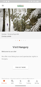
The online tourist guide of Hungary, specially developed for hikers, bikers, trailrunners, rockclimbers and water sports lovers, featuring a built-in tour planner, as well as hundreds of recommended tours and thousands of sights, all with detailed descriptions and plenty of photographs, comfortably viewable on an interactive map. Available for free, with a subscription option for extended functionality.
Features
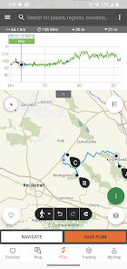
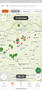
• Various interactive, zoomable, vectorized, worldwide hiking maps with all the marked trails, showing your current position
• A convenient way to plan your own tour on the map, and get length, duration and elevation profile immediately
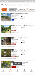
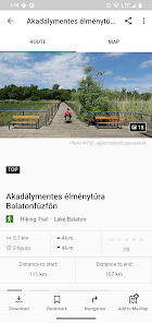
• More than a thousand recommended tours for hikers, bikers, trail runners and canoers, with practical data, detailed description of the best sights nearby, natural and cultural background, good quality photographs and information on how to get there
• Thousands of recommended sights in Hungary, including lookout towers, natural panorama points, forest trains, fortresses and museums, with detailed description, good quality photographs, plus information on how to get there
• Hundreds of accommodations, including huts, tourist hotels and apartments, near marked trails
• Useful collections with map view: beaches around lake Balaton, ice-skating arenas, botenical gardens, the best trail-running routes, rock-climbing places, tours for people living with disabilities etc.
• Notices, warnings and closures
• Download map sections, tours and sights for offline use
• On-the-fly navigation along the route with a live elevation profile and voice instructions
• Record your route
• BuddyBeacon: share your positon with friends live
• The complete Hungarian Blue Tour, with official sections and route, POIs and accomodations
• Synchronise all your content between computer and mobile devices running the app
• Check the local weather forecast
• 3D-flight: a virtual bird’s eye view of the tour
• Useful tools built in, such as peak finder(Skyline) and compass with your current position
• Community services: rate and share contents with your friends
Smartwatches with WEAR OS from Google
With a glance at your Smartwatch, you get information about your GPS position on the map. You can record tracks, get tracking data and navigate along routes. Use the app tile to easily access nearby routes.
Exclusively for Pro members
Go anywhere : Outdooractive Pro works offline without mobile and data signals. Unlimited lists can also be created and the app is ad-free. In addition, you are able to view satellite imagery, the unique Outdooractive map with over 30 activity trail networks and official topographic maps from the following providers:
Great Britain Ordnance Survey, Landranger, Explorer
New Zealand Land Information
Utah USGS
Germany BKG
Austria BEV
Switzerland swisstopo
France IGN
Spain CNIG
Italy
Netherlands PDOK
Norway Kartverket
Denmark Kortforsyningen
Sweden Lantmäteriet
Finland National Land Survey
Japan GSI
Global Map
Exclusively for Pro+ members
Pro+ also contains official maps from Alpine Associations as well as premium maps from KOMPASS.
If you have questions or suggestions, please visit
https://www.termeszetjaro.hu/hu/p/gyakran-ismetelt-kerdesek/41050512/
Our desktop version:
https://www.termeszetjaro.hu/
Follow us on Facebook:
https://www.facebook.com/Termeszetjaro.hu/
Contact us:
termeszetjaro@termeszetjaro.hu
More about the TEKA card:
http://www.termeszetjarokartya.hu/
Features
• Various interactive, zoomable, vectorized, worldwide hiking maps with all the marked trails, showing your current position
• A convenient way to plan your own tour on the map, and get length, duration and elevation profile immediately
• More than a thousand recommended tours for hikers, bikers, trail runners and canoers, with practical data, detailed description of the best sights nearby, natural and cultural background, good quality photographs and information on how to get there
• Thousands of recommended sights in Hungary, including lookout towers, natural panorama points, forest trains, fortresses and museums, with detailed description, good quality photographs, plus information on how to get there
• Hundreds of accommodations, including huts, tourist hotels and apartments, near marked trails
• Useful collections with map view: beaches around lake Balaton, ice-skating arenas, botenical gardens, the best trail-running routes, rock-climbing places, tours for people living with disabilities etc.
• Notices, warnings and closures
• Download map sections, tours and sights for offline use
• On-the-fly navigation along the route with a live elevation profile and voice instructions
• Record your route
• BuddyBeacon: share your positon with friends live
• The complete Hungarian Blue Tour, with official sections and route, POIs and accomodations
• Synchronise all your content between computer and mobile devices running the app
• Check the local weather forecast
• 3D-flight: a virtual bird’s eye view of the tour
• Useful tools built in, such as peak finder(Skyline) and compass with your current position
• Community services: rate and share contents with your friends
Smartwatches with WEAR OS from Google
With a glance at your Smartwatch, you get information about your GPS position on the map. You can record tracks, get tracking data and navigate along routes. Use the app tile to easily access nearby routes.
Exclusively for Pro members
Go anywhere : Outdooractive Pro works offline without mobile and data signals. Unlimited lists can also be created and the app is ad-free. In addition, you are able to view satellite imagery, the unique Outdooractive map with over 30 activity trail networks and official topographic maps from the following providers:
Great Britain Ordnance Survey, Landranger, Explorer
New Zealand Land Information
Utah USGS
Germany BKG
Austria BEV
Switzerland swisstopo
France IGN
Spain CNIG
Italy
Netherlands PDOK
Norway Kartverket
Denmark Kortforsyningen
Sweden Lantmäteriet
Finland National Land Survey
Japan GSI
Global Map
Exclusively for Pro+ members
Pro+ also contains official maps from Alpine Associations as well as premium maps from KOMPASS.
If you have questions or suggestions, please visit
https://www.termeszetjaro.hu/hu/p/gyakran-ismetelt-kerdesek/41050512/
Our desktop version:
https://www.termeszetjaro.hu/
Follow us on Facebook:
https://www.facebook.com/Termeszetjaro.hu/
Contact us:
termeszetjaro@termeszetjaro.hu
More about the TEKA card:
http://www.termeszetjarokartya.hu/
Updated on
Safety starts with understanding how developers collect and share your data. Data privacy and security practices may vary based on your use, region, and age. The developer provided this information and may update it over time.


What's new
Bug fixes


