PasoTours
100+
Downloads

Everyone
info

About this app
Touring through Wine and Farming Country in Paso Robles.
The Paso Robles wine growing region features rolling hills spotted with live oak trees nestled amongst vineyards and agricultural landscapes.
This application shows you the location and information about wineries, farms, olive oil production, roadside food stands, and some of our favorite restaurants in California's Central Coast.
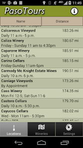
- Includes a local database of over 200 wineries, olive oil tasting, farm stands and farms with tours, food providers, and restaurants
- Data is not downloaded from a website so Internet connection is not required though is needed for Google Map updating.
- Map data is cached to allow touring in areas without internet service.
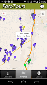
- Filter by type of locations (Winery, Olive Oil, Farm, or Food)
- Approximate distance from location to current position is shown. *Location services required.
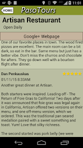
- Detailed view with information about the location. You can also launch the map application to get directions, check the website, call, or send email.
We rely on user feedback to improve the data and add new locations.
* Note: Since many of the back roads in Paso Robles are out of cell phone range, make sure and view the maps of the area in the Application while you are within coverage. That way the map will be in the memory cache while you are driving around. The application stores all the contact and address information locally but does rely on Google maps for map updating.
The Paso Robles wine growing region features rolling hills spotted with live oak trees nestled amongst vineyards and agricultural landscapes.
This application shows you the location and information about wineries, farms, olive oil production, roadside food stands, and some of our favorite restaurants in California's Central Coast.
- Includes a local database of over 200 wineries, olive oil tasting, farm stands and farms with tours, food providers, and restaurants
- Data is not downloaded from a website so Internet connection is not required though is needed for Google Map updating.
- Map data is cached to allow touring in areas without internet service.
- Filter by type of locations (Winery, Olive Oil, Farm, or Food)
- Approximate distance from location to current position is shown. *Location services required.
- Detailed view with information about the location. You can also launch the map application to get directions, check the website, call, or send email.
We rely on user feedback to improve the data and add new locations.
* Note: Since many of the back roads in Paso Robles are out of cell phone range, make sure and view the maps of the area in the Application while you are within coverage. That way the map will be in the memory cache while you are driving around. The application stores all the contact and address information locally but does rely on Google maps for map updating.
Updated on
Data safety
Developers can show information here about how their app collects and uses your data. Learn more about data safety

No information available
What's new
Touring through Wine and Farming Country in Paso Robles.
Now with Google+ Reviews and Web page links.
Now with Google+ Reviews and Web page links.