
TopoDroid
4.2star
488 reviews
100K+
Downloads

Everyone
info


About this app
TopoDroid - Cave surveying on Android
For the latest apks go to speleoapps.
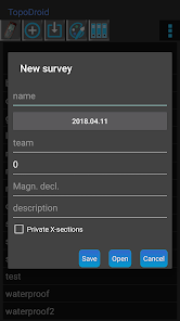
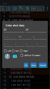
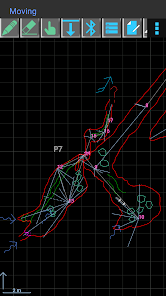
TopoDroid helps you to take survey data and accurate sketches while you are in the cave, so that you can detect errors in the data while you are still on the spot and correct them. TopoDroid has many functions to help you get the most out of a surveying trip. In this way, by the time you finish it, a working map is almost ready.
TopoDroid is designed to work *ONLY* with the DistoX, SAP5 and BRIC4. The survey data can be also entered by hand. TopoDroid has DistoX calibration functions, as well as other advanced DistoX functions.
The DistoX is not a Leica product, and TopoDroid does not work with any Leica Disto.
TopoDroid handles one survey session at a time. It is not a cave survey project manager. For that purpose there are many good PC programs, and TopoDroid exports survey data in several cave program formats (among them: therion, compass, visualtopo, walls, survex), as well as dxf, csv, kml, trackfile, shapefile. Sketches can be exported as therion, csurvey, dxf, svg, shapefile, and png image.
Full list of features, user manual, and docs on https://sites.google.com/site/speleoapps/home/topodroid
DISCLAIMER
This app is open-source, free and ad-free. It has no warranty. By using it you agree that the author is not responsible for any loss of data you might incur, or damage whatsoever, including damages to DistoX devices.
ANDROID PERMISSIONS
- TopoDroid requires the following permissions: WRITE_EXTERNAL_STORAGE, BLUETOOTH, BLUETOOTH_ADMIN
- Certain functions depend on these permissions:
CAMERA (photos at stations and legs), RECORD_AUDIO (audio recording station comments), ACCESS_FINE_LOCATION (entrances geolocation).
- INTERNET permission is necessary only if you plan to install translations of the user manual.
CRASHES
Before complaining for a crash, switch to English.
Other languages may cause crashes due to missing translations.
BETA and OLD APKS
TopoDroid has an open-beta program: opt-in link on the website.
A few apks of old versions are available on the website.
TRANSLATIONS
M. Guerrero (spanish), D. Ros (french), A. Kozhenkov (russian), V. Georgiev (bulgarian), M. Keller (german), F. Toso (italian), H.-J. Luo (chinese), P. Suru (hungarian), R. Severo (potuguese), M. Jurecka (slovak), K. Borgiel (polish), A. Pologea (romanian)
For the latest apks go to speleoapps.
TopoDroid helps you to take survey data and accurate sketches while you are in the cave, so that you can detect errors in the data while you are still on the spot and correct them. TopoDroid has many functions to help you get the most out of a surveying trip. In this way, by the time you finish it, a working map is almost ready.
TopoDroid is designed to work *ONLY* with the DistoX, SAP5 and BRIC4. The survey data can be also entered by hand. TopoDroid has DistoX calibration functions, as well as other advanced DistoX functions.
The DistoX is not a Leica product, and TopoDroid does not work with any Leica Disto.
TopoDroid handles one survey session at a time. It is not a cave survey project manager. For that purpose there are many good PC programs, and TopoDroid exports survey data in several cave program formats (among them: therion, compass, visualtopo, walls, survex), as well as dxf, csv, kml, trackfile, shapefile. Sketches can be exported as therion, csurvey, dxf, svg, shapefile, and png image.
Full list of features, user manual, and docs on https://sites.google.com/site/speleoapps/home/topodroid
DISCLAIMER
This app is open-source, free and ad-free. It has no warranty. By using it you agree that the author is not responsible for any loss of data you might incur, or damage whatsoever, including damages to DistoX devices.
ANDROID PERMISSIONS
- TopoDroid requires the following permissions: WRITE_EXTERNAL_STORAGE, BLUETOOTH, BLUETOOTH_ADMIN
- Certain functions depend on these permissions:
CAMERA (photos at stations and legs), RECORD_AUDIO (audio recording station comments), ACCESS_FINE_LOCATION (entrances geolocation).
- INTERNET permission is necessary only if you plan to install translations of the user manual.
CRASHES
Before complaining for a crash, switch to English.
Other languages may cause crashes due to missing translations.
BETA and OLD APKS
TopoDroid has an open-beta program: opt-in link on the website.
A few apks of old versions are available on the website.
TRANSLATIONS
M. Guerrero (spanish), D. Ros (french), A. Kozhenkov (russian), V. Georgiev (bulgarian), M. Keller (german), F. Toso (italian), H.-J. Luo (chinese), P. Suru (hungarian), R. Severo (potuguese), M. Jurecka (slovak), K. Borgiel (polish), A. Pologea (romanian)
Updated on
Data safety
Developers can show information here about how their app collects and uses your data. Learn more about data safety

No information available
Ratings and reviews
4.2
450 reviews

Vladimír Fuka
- Flag inappropriate
March 31, 2023
The description should really say that this version is old and will not work with new devices. New APK must be doenloaded elsewhere (sadly from a http, not https site).
4 people found this review helpful

ivana m
- Flag inappropriate
- Show review history
July 30, 2020
it's an extremely useful app:) i just like to use it! by years, it has become an inseparable part of caving.
36 people found this review helpful
marco.corvi
July 30, 2020
thanks. i'm glad that cavers find the app useful.

A Google user
- Flag inappropriate
- Show review history
October 29, 2018
The best do-everything mobile digital cave survey application.
61 people found this review helpful
marco.corvi
May 24, 2020
thanks
What's new
DXF export with colors (thanks to B. Holl).
Generic "options" directive for point symbols.
Apk for Android-11 and later elsewhere (thanks to Google)
Generic "options" directive for point symbols.
Apk for Android-11 and later elsewhere (thanks to Google)


