

Maps Measure
In-app purchases

4.4star
8.62K reviews
500K+
Downloads

Everyone
info

About this app
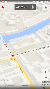
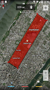
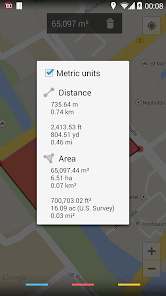
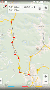
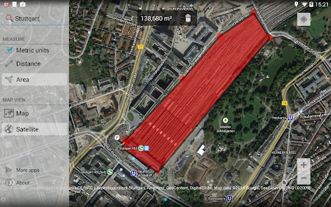
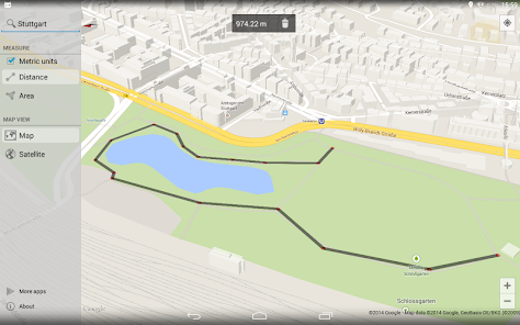
Simple app to measure distances and areas in Google Maps.
Just click on the map to add different points - Maps Measure will then calculate the distance, area or elevation* between those points.
This app does not calculate a route or something like that - it's not a navigation or route planning app.
Swipe in from the left side to access more options, long-click on the trash icon to delete all set points.
Features:
• Measure distances, areas & elevations*
• Imperial & metric units
• Map, hybrid-satellite & terrain view
• No ads
• Minimum permissions & open source
• Holo-themed with support for translucent system decor on Android 4.4
*the elevations feature requires an in-app purchase (0.99 EUR, 1.49 USD)
Permissions:
INTERNET & ACCESS_NETWORK_STATE - showing the map and getting altitude data
WRITE_EXTERNAL_STORAGE - caching map data
ACCESS_COARSE_LOCATION & ACCESS_FINE_LOCATION - displaying your current location on the map
BILLING - upgrade to the pro-version through an in-app purchase
The app does not show any ads or collects any of your data.
The app is open source and listed on GitHub: https://github.com/j4velin/MapsMeasure
Icon provided by https://github.com/amirdesaingrafis
Updated on
Safety starts with understanding how developers collect and share your data. Data privacy and security practices may vary based on your use, region, and age. The developer provided this information and may update it over time.

No data shared with third parties
Learn more about how developers declare sharing

No data collected
Learn more about how developers declare collection