
Bahrain offline map
10+
Downloads

Everyone
info


About this app
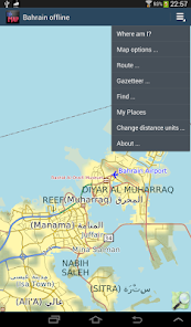
Offline map of the Gulf state of Bahrain for business and tourist visitors. Download the app before you go or using your hotel's Wi-Fi and avoid expensive roaming charges. The map runs completely on your device; map display with pan and infinite zoom, routing, searching, everything. It does not use your data connection at all. Switch your phone function off if you want to! NSA proof!
No ads. All features fully functional on installation, you do not need to buy add-ons or do extra downloads.
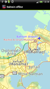
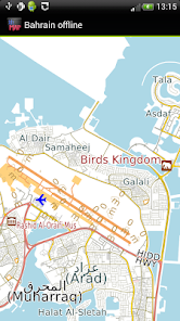
The map includes the entire country and is based on OpenStreetMap data, http://www.openstreetmap.org.
Is it all in Arabic?
No. We have made the map in Arabic and "English". 99% of the map is either in both scripts or just "English". We have also tried where possible to show "English" locations when using the Find and Gazetteer functions. Relax and enjoy!
How good is the map?
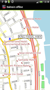
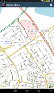
All the roads are there and many named. Expatriate hotels and eating places appear to be well mapped, as is the airport. Cities and towns are named but a lot of smaller place names are still missing. Other general amenities such as bank, doctors, hospitals are still patchy.
You can help improve it by becoming an OpenStreetMap contributor. We will publish app updates with new information.
Terrain is shown on the map, and can be turned on or off.
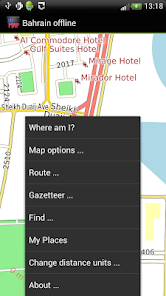
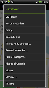
The app includes a search function and a gazetteer of commonly needed items like hotels, eating places, post offices and pharmacies as well as museums and other things to see and do.
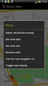
Turn-by-turn navigation is available on devices running Android 3.0 or higher.
Navigation will show you an indicative route and can be configured for car, bicycle or foot. The developers provide it without any guarantee that it is always correct. For example, it does not show turn restrictions - places where it is illegal to turn. Some rural roads may be suitable for four-wheel drive vehicles only and/or for people familiar with the area and terrain. Use with care and above all look out for and obey road signs.
You can bookmark places like your hotel in "My Places" for easy return navigation.
We hope it does not happen to you but: Like most small developers, we cannot test a wide variety of phones and tablets. If you have trouble running the application, do email us and we will try to help.
No ads. All features fully functional on installation, you do not need to buy add-ons or do extra downloads.
The map includes the entire country and is based on OpenStreetMap data, http://www.openstreetmap.org.
Is it all in Arabic?
No. We have made the map in Arabic and "English". 99% of the map is either in both scripts or just "English". We have also tried where possible to show "English" locations when using the Find and Gazetteer functions. Relax and enjoy!
How good is the map?
All the roads are there and many named. Expatriate hotels and eating places appear to be well mapped, as is the airport. Cities and towns are named but a lot of smaller place names are still missing. Other general amenities such as bank, doctors, hospitals are still patchy.
You can help improve it by becoming an OpenStreetMap contributor. We will publish app updates with new information.
Terrain is shown on the map, and can be turned on or off.
The app includes a search function and a gazetteer of commonly needed items like hotels, eating places, post offices and pharmacies as well as museums and other things to see and do.
Turn-by-turn navigation is available on devices running Android 3.0 or higher.
Navigation will show you an indicative route and can be configured for car, bicycle or foot. The developers provide it without any guarantee that it is always correct. For example, it does not show turn restrictions - places where it is illegal to turn. Some rural roads may be suitable for four-wheel drive vehicles only and/or for people familiar with the area and terrain. Use with care and above all look out for and obey road signs.
You can bookmark places like your hotel in "My Places" for easy return navigation.
We hope it does not happen to you but: Like most small developers, we cannot test a wide variety of phones and tablets. If you have trouble running the application, do email us and we will try to help.
Updated on
Safety starts with understanding how developers collect and share your data. Data privacy and security practices may vary based on your use, region, and age. The developer provided this information and may update it over time.

No data shared with third parties
Learn more about how developers declare sharing

This app may collect these data types
App activity, App info and performance, and Device or other IDs

Data is encrypted in transit

Data can’t be deleted
What's new
- Latest OpenStreetMap data
- Android 10 compatibility
- Removed "Advanced Find" menu item to simplify the app, contact us via our Developer Email on the Google Play Store if you want this back.
- Added Crashlytics. If the app crashes, information about the crash is automatically sent to us. No personal data is sent. Your location is not sent.
- Ski runs and ski lifts now show where applicable
- Reservoir dams now show
- Some map style tweaks, e.g service roads thinner to contrast them better.


