
J-SHIS
10K+
Downloads

Everyone
info
About this app
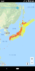
J-SHIS is an official application for Android that displays a national seismic motion prediction map on Google Maps. The "National Seismic Motion Prediction Map" predicts strong tremors caused by earthquakes that may occur in Japan in the future, and shows the prediction results as a map.
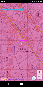
○ Display of national earthquake motion prediction map
You can display the latest national seismic motion prediction map that is currently open to the public. The map can be enlarged / reduced, moved, and the transparency can be changed.
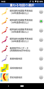
・ Probabilistic seismic motion prediction map (probability of 30-year seismic intensity 6 or higher)
・ Probabilistic seismic motion prediction map (probability of 30-year seismic intensity 6 lower or higher)
・ Probabilistic seismic motion prediction map (probability of 30-year seismic intensity of 5 or higher)
・ Probabilistic seismic motion prediction map (probability of 30-year seismic intensity of 5 lower or higher)
・ Long-term average hazard map
・ Surface ground map
・ Deep ground map
・ Assumed earthquake map
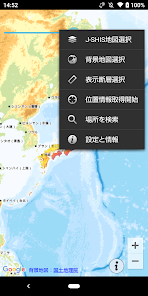
○ Display of source fault and seismic activity model
Major active fault zones and subduction-zone seismic source faults can be displayed on the map. Tap the source fault to display the seismic activity model (average case).
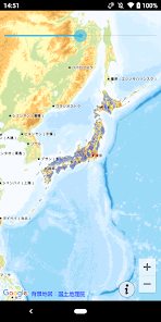
○ Display around the current position using GPS
The map display range can be set to the area around the current position using GPS.
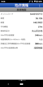
○ Display of location information
It is possible to display the probability of being hit by a shaking with a seismic intensity of 6 lower or higher at a specified point for 30 years and the surface ground amplification factor.
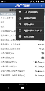
○ Display of earthquake hazard chart
From the point information, you can display the earthquake hazard chart that summarizes the earthquake hazard information of each point.
○ Display of national earthquake motion prediction map
You can display the latest national seismic motion prediction map that is currently open to the public. The map can be enlarged / reduced, moved, and the transparency can be changed.
・ Probabilistic seismic motion prediction map (probability of 30-year seismic intensity 6 or higher)
・ Probabilistic seismic motion prediction map (probability of 30-year seismic intensity 6 lower or higher)
・ Probabilistic seismic motion prediction map (probability of 30-year seismic intensity of 5 or higher)
・ Probabilistic seismic motion prediction map (probability of 30-year seismic intensity of 5 lower or higher)
・ Long-term average hazard map
・ Surface ground map
・ Deep ground map
・ Assumed earthquake map
○ Display of source fault and seismic activity model
Major active fault zones and subduction-zone seismic source faults can be displayed on the map. Tap the source fault to display the seismic activity model (average case).
○ Display around the current position using GPS
The map display range can be set to the area around the current position using GPS.
○ Display of location information
It is possible to display the probability of being hit by a shaking with a seismic intensity of 6 lower or higher at a specified point for 30 years and the surface ground amplification factor.
○ Display of earthquake hazard chart
From the point information, you can display the earthquake hazard chart that summarizes the earthquake hazard information of each point.
Updated on
Safety starts with understanding how developers collect and share your data. Data privacy and security practices may vary based on your use, region, and age. The developer provided this information and may update it over time.

No data shared with third parties
Learn more about how developers declare sharing

No data collected
Learn more about how developers declare collection
What’s new
2024年(NIED作成版)に対応しました。