Being the most popular parallel driving application for Precision Agriculture, it can save money by just installing - no need for additional expensive equipment. Measure the size of your farm, field or grassland easily and hassle-free, even in poor conditions or low visibility.
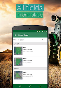
Save field data, borders and guidance lines, mark obstacles and create a database of your requirement. With Field Navigator Steering Assistance driving to parallel tracks is much easier, reducing the workload, size of untreated areas and avoiding overlaps.
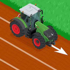
Field Navigator includes the use of Straight AB parallel lines while navigating in the field.
This app is perfect for large and small farm owners, practitioners, learners and professionals of Precision Agriculture.
❖ RECOMMENDATIONS
If built-in GPS receiver is not accurate enough, the connection of external Bluetooth GPS receiver is advised, specifically GARMIN GLO, which gives the accuracy of 0.3 m – tried and tested by ourselves.
* The app perfectly works with a GARMIN GLO and GARMIN GLO 2 external GPS antennas.
❖ FEATURES
➜ Navigate in parallel lines while driving in the field
➜ Navigate and create tracks on Google Maps in satellite view
➜ Create fields database by using GPS or manually
➜ Measure field area and perimeter by using GPS or manually by selecting points on the map
➜ Import field data in *.shp / *.kml formats
➜ Export field data in *.kml format
➜ Share field data
❖ SOON:
➜ AB Curve
➜ Headland
➜ Obstacle positions
➜ Farming activities database
➜ Driving assistance in 3D mode without maps
➜ Night mode for farming at night time
❖ HOW TO USE:
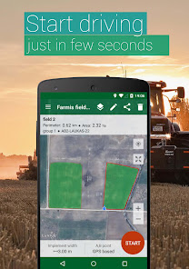
1. To start parallel driving you have to create a field (irregular hexagon icon at top right corner)
2. Choose implement width and parallel navigation lines creating mode
3. Click "Start" and further steps will be displayed on the top navigation panel
❖ We are also recommending our other app:
➜ GPS Fields Area Measure PRO
goo.gl/dxKHXJ
Farming meanings: RTK, GPS, GLONAS, GARMIN, external gps receiver, parallel driving, automatic steering, SECTION-Control BOX and ISOBUS machine control, farming app, fields, field note, farmers, farmer union, ministry of agriculture, crop protection products, pesticides, herbicides, fungicides, insecticides, tractor, steering tractor, steering harvester, guidance, auto guidance in the field, variable fertilizing rate, variable spraying rate, seeding rate. Field Navigator parallel driving useful tool while harvesting cereal, grain, maize, corn, wheat, soybean, barley, cotton and other agricultural cultures in farm fields. Good for farm contractors, tractor rent companies who is working with john deere, new holland, case, class, agco, laverda, waderstad, simba, krone, kuhn, amazone, kverneland, hardi and other farming equipment. driving Trajectory, field boundaries, Autosteering, Guidance, Accuracy, Seeding, Planting, Spraying, Spreading, Crop Sensing, Harvest, Grassfield, Farm, Measuring, Perimeter, Area Measuring.