
Mergin Maps: QGIS in pocket
4.5star
315 reviews
100K+
Downloads

Everyone
info


About this app
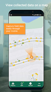
Mergin Maps is a field data collection tool built on the free and open-source QGIS which allows you to collect, store and synchronise your data with your team. It removes the pain of writing down paper notes, georeferencing photos and transcribing GPS coordinates. With Mergin Maps, you can get your QGIS projects into the mobile app, collect data and synchronise it back on the server.
Setting up your project with Mergin Maps only takes a few minutes. First, create your survey project in QGIS, then connect it to Mergin Maps with a plugin and synchronise it with the mobile app to start collecting in the field.
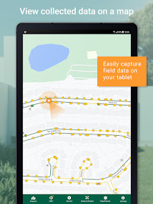
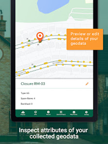
The data you capture in the field survey is shown on a map and can be exported to a wide variety of formats including CSV, Microsoft Excel, ESRI Shapefile, Mapinfo, GeoPackage, PostGIS, AutoCAD DXF, and KML.
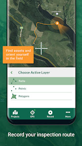
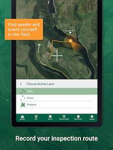
Mergin Maps allows you to do live position tracking, fill out survey forms and capture and edit points, lines or polygons. You can also connect external GPS/GNSS devices via Bluetooth for high-precision surveying. Map layers look the same as in QGIS desktop so you can set your layer symbology how you want it on the desktop and it will appear that way on your mobile device.
Mergin Maps supports offline field data capture for situations where a data connection is unavailable. It can be configured to use either offline or web-based background maps and contextual layers.
Perks of the Mergin Maps sync system:
- No need for cables to get your data on/off your device
- Share projects with others for collaborative working, even offline
- Updates from different surveyors are intelligently merged
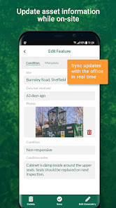
- Push data back from the field in real time
- Version history and cloud-based backup
- Fine-grained access control
- Record metadata such as EXIF, GPS and external GNSS device information
- Sync with your PostGIS datasets and external media storage such as S3 and MinIO
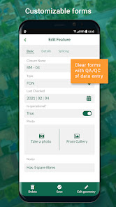
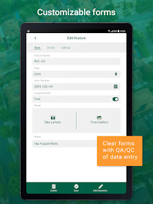
Supported field types for forms are:
- Text (single or multi-line)
- Numeric (plain, with +/- buttons or with slider)
- Date / time (with calendar picker)
- Photo
- Checkbox (yes/no values)
- Drop-down with predefined values
- Drop-down with values from another table
Setting up your project with Mergin Maps only takes a few minutes. First, create your survey project in QGIS, then connect it to Mergin Maps with a plugin and synchronise it with the mobile app to start collecting in the field.
The data you capture in the field survey is shown on a map and can be exported to a wide variety of formats including CSV, Microsoft Excel, ESRI Shapefile, Mapinfo, GeoPackage, PostGIS, AutoCAD DXF, and KML.
Mergin Maps allows you to do live position tracking, fill out survey forms and capture and edit points, lines or polygons. You can also connect external GPS/GNSS devices via Bluetooth for high-precision surveying. Map layers look the same as in QGIS desktop so you can set your layer symbology how you want it on the desktop and it will appear that way on your mobile device.
Mergin Maps supports offline field data capture for situations where a data connection is unavailable. It can be configured to use either offline or web-based background maps and contextual layers.
Perks of the Mergin Maps sync system:
- No need for cables to get your data on/off your device
- Share projects with others for collaborative working, even offline
- Updates from different surveyors are intelligently merged
- Push data back from the field in real time
- Version history and cloud-based backup
- Fine-grained access control
- Record metadata such as EXIF, GPS and external GNSS device information
- Sync with your PostGIS datasets and external media storage such as S3 and MinIO
Supported field types for forms are:
- Text (single or multi-line)
- Numeric (plain, with +/- buttons or with slider)
- Date / time (with calendar picker)
- Photo
- Checkbox (yes/no values)
- Drop-down with predefined values
- Drop-down with values from another table
Updated on
Safety starts with understanding how developers collect and share your data. Data privacy and security practices may vary based on your use, region, and age. The developer provided this information and may update it over time.

No data shared with third parties
Learn more about how developers declare sharing

This app may collect these data types
Location and Photos and videos

Data is encrypted in transit

You can request that data be deleted
Ratings and reviews
4.5
299 reviews

YPP Mappers
- Flag inappropriate
November 16, 2020
Great field survey app linked to a Cloud through Mergin. As a peatland restoration programme we conduct field surveys in the uplands of Autumn and Winter in the UK. We are quite frequently exposed to extreme weather conditions and gloves are required. With a stylus, I note that you can double tap the screen to zoom in, however this often highlights a layer and is sometimes intermittent. It would be fantastic if you could add in a zoom in/out function on the display. Thanks, Ollie
20 people found this review helpful
Lutra Consulting
November 16, 2020
Thanks for your review and reporting an issue. We have filed a bug and look into that in future releases: https://github.com/lutraconsulting/input/issues/1003

Adam Dawson
- Flag inappropriate
September 27, 2021
Great ap very easy to use and install and compatible with many GIS systems. I am using it to survey and map extent of invasive species across a catchment. Often chatting to landowners at the same time and have been able to map and chat simultaneously. I contacted Lutra regarding licencing and had a positive response within the hour. Excellent customer service. One star lost due to occasional stability issue, always resolved by restarting the ap without any data loss.
17 people found this review helpful

Clare E. Collins
- Flag inappropriate
May 12, 2023
Just what I was looking for. Easy to record data in the field, uploaded once able to and then downloaded to my own files, opened the QGIS file that was created and all the data was there. It would have been useful to have created new layers out in the field, but I believe there is a way to set this up from QGIS originally to allow this. I used the text fields for all data as the number field is integers only and the check box is true/false only... But text works well anyway. Really impressed.
6 people found this review helpful
What's new
- Fix download of files >= 2GB
- Download data in parallel during sync
- Show outdated server version dialogue
- Added changelog
- Add support for pg_service.conf file
- Upgrade to Qt 6.6.0
- Fix of QR code
- Add mergin_user_email as new global variable
- Fix storing Z and M values when tracking
- Download data in parallel during sync
- Show outdated server version dialogue
- Added changelog
- Add support for pg_service.conf file
- Upgrade to Qt 6.6.0
- Fix of QR code
- Add mergin_user_email as new global variable
- Fix storing Z and M values when tracking


