Waverley Transport: Maps, Time
50+
Downloads

Everyone
info
About this app
Waverley Transport app is great as a route planner including private and public transport. With a tap on your phone you can - Get directions, city maps, timing, train & bus timetable, check fares, save favourite stops & get real-time information for all transit types. The app provides you the efficient and affordable ways to commute and travel across Sydney & NSW.
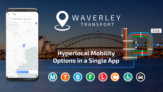
Waverley Transport is your mobility partner to guide & plan your journey with all transport modes:- 🚍 bus 🚆 train 🚇 metro 🚋 tram ⛴ ferry 🚕 ride services 🚗 wheelchair accessible taxi 🚙 car share 🚴 bicycle and🚶walking
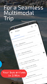
Find the closest stop, and easily check which ride is next there!
FEATURES OF WAVERLEY TRANSPORT:
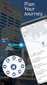
✔️ Detailed directions across combinations of transport modes (public & private). Find the best combinations of trips to your destination.
✔️ Provides safe and continuous routes for trams, wheelchairs, and children on bicycles
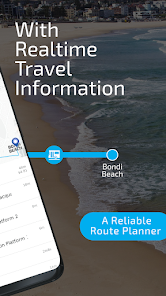
✔️ Step-by-step directions, details of street-by-street turns, stop-by-stop timings, wait timings etc.
✔️ Encourages the use of designated safe pick-up/drop-off (PUDO) zones
✔️ Reliable route planner - Know Train & Bus timetable to check out which ride is next there!
✔️ Trip planner with city maps, fare estimates, vehicle operating costs, tolls, etc.
✔️ Save bus stops and train stations.
✔️ EV charging locations to plan longer transit trips 🔌⚡💡
✔️ Personalize your trips by picking your route preferences.
ONE APP FOR ALL TRANSPORT MODES FOR SYDNEY NSW TO REACH NEXT THERE STOP:
Public transport includes trains, metro trains, buses, ferries, and light rail trams. Private transport includes rental cars, ride services, car share, cab, taxi, wheelchair taxi, walking, cycling etc.
🚉 Major Sydney NSW trains interchanges: 🚉
⚬ Central Station
⚬ Chatswood Station
⚬ Circular Quay Station
⚬ North Sydney Station
⚬ Parramatta Station
⚬ Town Hall Station
⚬ Bondi Junction Station
🚏 Major bus stops: 🚏
⚬ Bondi Beach
⚬ Westfield Bondi Junction
⚬ Maroubra
⚬ Parramatta
⚬ Randwick
⚬ Sydney CBD
⚬ Surry Hills
👉👉 Some more interesting features given below are coming soon in your trip planner app for Sydney NSW 👈👈
📱 LIVE Maps & Notifications during your trip
↗️ Turn-by-turn Navigation
📥 Save Favorite Destinations
& many more..
So, why wait! Let’s make your trip easy.
➡️➡️➡️ Download Waverley Transport App and route planner and check train & bus timetable, as well as other private and public transport options and city maps.
Keep in touch❤️ If you have questions or any feedback for us, email us at waverley.play@SmartCitiesTransport.com
Ride with the best. Ride the Waverley!
Waverley Transport is your mobility partner to guide & plan your journey with all transport modes:- 🚍 bus 🚆 train 🚇 metro 🚋 tram ⛴ ferry 🚕 ride services 🚗 wheelchair accessible taxi 🚙 car share 🚴 bicycle and🚶walking
Find the closest stop, and easily check which ride is next there!
FEATURES OF WAVERLEY TRANSPORT:
✔️ Detailed directions across combinations of transport modes (public & private). Find the best combinations of trips to your destination.
✔️ Provides safe and continuous routes for trams, wheelchairs, and children on bicycles
✔️ Step-by-step directions, details of street-by-street turns, stop-by-stop timings, wait timings etc.
✔️ Encourages the use of designated safe pick-up/drop-off (PUDO) zones
✔️ Reliable route planner - Know Train & Bus timetable to check out which ride is next there!
✔️ Trip planner with city maps, fare estimates, vehicle operating costs, tolls, etc.
✔️ Save bus stops and train stations.
✔️ EV charging locations to plan longer transit trips 🔌⚡💡
✔️ Personalize your trips by picking your route preferences.
ONE APP FOR ALL TRANSPORT MODES FOR SYDNEY NSW TO REACH NEXT THERE STOP:
Public transport includes trains, metro trains, buses, ferries, and light rail trams. Private transport includes rental cars, ride services, car share, cab, taxi, wheelchair taxi, walking, cycling etc.
🚉 Major Sydney NSW trains interchanges: 🚉
⚬ Central Station
⚬ Chatswood Station
⚬ Circular Quay Station
⚬ North Sydney Station
⚬ Parramatta Station
⚬ Town Hall Station
⚬ Bondi Junction Station
🚏 Major bus stops: 🚏
⚬ Bondi Beach
⚬ Westfield Bondi Junction
⚬ Maroubra
⚬ Parramatta
⚬ Randwick
⚬ Sydney CBD
⚬ Surry Hills
👉👉 Some more interesting features given below are coming soon in your trip planner app for Sydney NSW 👈👈
📱 LIVE Maps & Notifications during your trip
↗️ Turn-by-turn Navigation
📥 Save Favorite Destinations
& many more..
So, why wait! Let’s make your trip easy.
➡️➡️➡️ Download Waverley Transport App and route planner and check train & bus timetable, as well as other private and public transport options and city maps.
Keep in touch❤️ If you have questions or any feedback for us, email us at waverley.play@SmartCitiesTransport.com
Ride with the best. Ride the Waverley!
Updated on
Safety starts with understanding how developers collect and share your data. Data privacy and security practices may vary based on your use, region, and age. The developer provided this information and may update it over time.

No data shared with third parties
Learn more about how developers declare sharing

No data collected
Learn more about how developers declare collection
What's new
2021-04-19 - Report feedback easily
2021-04-17 - Wheelchair accessibility details for complex stations
2021-04-02 - Wheelchair accessibility information ♿
2021-03-19 - Bottom menu bar for quick navigation
2021-03-16 - Wheelchair accessible data on the map
2020-07-26 - Detailed directions 🧭
2020-07-11 - EV charging layers 🔋
2020-07-04 - Departure times of nearest and favourite stops🚏
2020-07-02 - Show Waverley Council data on the map 🇦🇺