
Peakview [Trial]
Contains ads

3.8star
750 reviews
100K+
Downloads

Rated for 3+
info
About this app
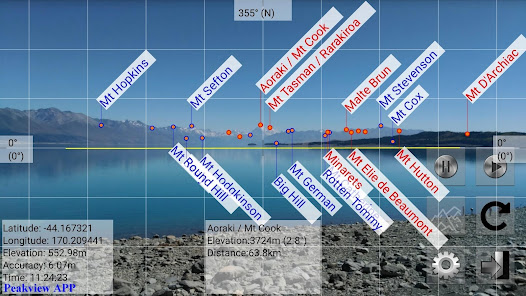
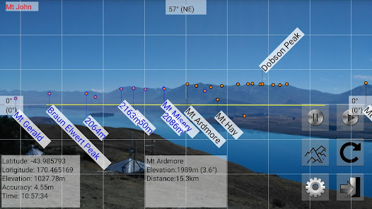
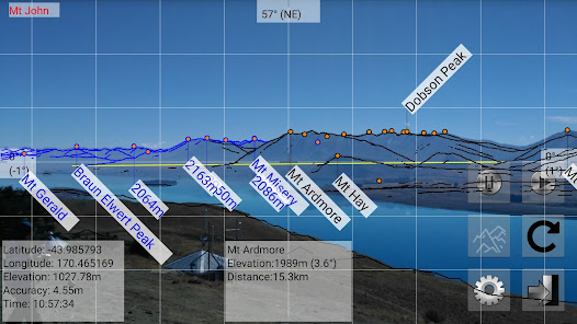
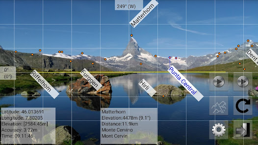
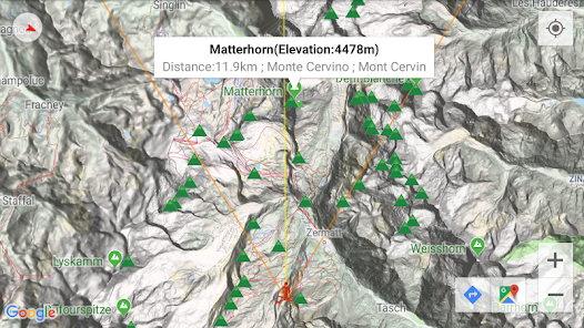
Peakview is a peak identification app. Through augmented reality (AR) technology, Peakview combines mountain names with the camera preview. It displays peak names on your mobile device's screen. When you go hiking, this app can help you to understand your environment. You can identify the mountains surrounding you. It is a good tool for climbers.
Before using this application, please read the following user's manual (PDF).
https://www.peakviewer.com/guide/Peakview_EN_20191016.pdf
Moreover, you can watch the following video.
https://www.youtube.com/watch?v=GkEb13zHNpA
Paid version link: https://play.google.com/store/apps/details?id=com.peakviewer.tw
■ Currently supported areas (can be added or deleted from "Settings" → "Selection of country/region")
□ Americas: Canada; United States
□ Asia: Hong Kong, Macau; Japan [complete]; Taiwan [complete]
□ Europe: There is support throughout Europe. The information in Germany, Ireland, Liechtenstein, Switzerland, and the United Kingdom is relatively complete.
□ Oceania: New Zealand [complete]
Updated on
Safety starts with understanding how developers collect and share your data. Data privacy and security practices may vary based on your use, region, and age. The developer provided this information and may update it over time.


Ratings and reviews
3.8
732 reviews

sumit bajracharya
- Flag inappropriate
December 20, 2021
App is very simple and helpful. When you are traveling, hiking or trekking You see the montains and wonder which mountain is which. This app interestingly gives your answer just by point your camera to them. The ony issue I find is calibration, the name of mountains appears fev centimeters away from what we see on the camera. Rest is good. Cheers 🥂
5 people found this review helpful
Peakview Team
February 16, 2022
Thank you for your beautiful comment.
We use a magnetic sensor to identify azimuth angles. It is captured by the Android system. It depends on your hardware equipment. It may be incorrect. Please read https://peakviewer.com/guide/en.pdf (page IV) for more details.

R H
- Flag inappropriate
September 26, 2022
Not work. Tried to repeatedly to download it and it would keep crashing. I got it downloaded so I could use it in the alps, it would crash every time I opened it. I tried to download the correct geographic area, and it kept crashing. Don't waste your time or money.

Alan Paterson
- Flag inappropriate
June 28, 2021
Not easy to use. A map and compass would be easier. Bounced all over the place. Uninstalled.
1 person found this review helpful
What's new
Version 6.6
■ Fixed the problem that the map will crash when the Geo-data is error.
Version 6.5
■ Access location information in the foreground service. (Android 10+)
■ Geoid on / off
■ Add Google ads. (The interval between ads will not be less than 30 minutes, and the shape of the mountains can be displayed 10 times after the ad appears)
■ Cancel the one-year limitation
■ Bug fix
Version 6.4
■ Instructions before use
■ Compass calibration