
Corfu offline map
100+
Preuzimanja

Svako
info

O aplikaciji
Offline map of Corfu island, Greece for tourist and business visitors. Download the app before you go or using your hotel's Wi-Fi and avoid expensive roaming charges. The map runs completely on your device; map, routing, searching, everything. It does not use your data connection at all. Switch your phone function off if you want to. NSA proof!
Is it all in Greek? We have made the map in Greek and "English". Bilingual information from the original map data is used where available and, in just a few cases, we have filled in with our automatic transliteration technology. Relax and enjoy!
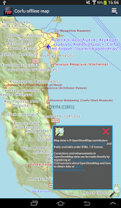
The map is based on OpenStreetMap data, http://www.openstreetmap.org.
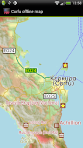
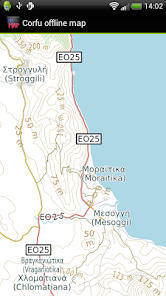
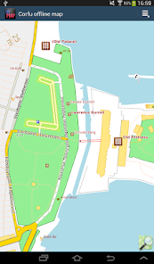
What is good in Corfu: Island roads, tracks, footpaths, airports, things to do and see appear very well mapped.
What is not so good: Coverage of hotels, tourist eating places and amenities like banks is reasonable but not complete. Smaller roads sometimes lack names. You can help improve it by becoming an OpenStreetMap contributor. We will publish app updates with new information.
Terrain is shown on the map, and can be turned on or off.
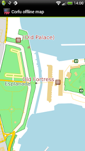
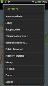
The app includes a search function and a gazetteer of commonly needed items like hotels, eating places, post offices and pharmacies as well as museums and other things to see and do.
You can bookmark places like your hotel for easy return route setting.
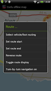
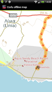
Turn-by-turn navigation is available on devices with GPS. If you don't have a GPS, you can still show a route between two locations.
Navigation will show you an indicative route and can be configured for car, bicycle or foot. The developers provide it without any guarantee that it is always correct. For example, it does not show turn restrictions - places where it is illegal to turn. Some rural roads may be suitable for four-wheel drive vehicles only and/or for people familiar with the area and terrain. Use with care and above all look out for and obey road signs.
Is it all in Greek? We have made the map in Greek and "English". Bilingual information from the original map data is used where available and, in just a few cases, we have filled in with our automatic transliteration technology. Relax and enjoy!
The map is based on OpenStreetMap data, http://www.openstreetmap.org.
What is good in Corfu: Island roads, tracks, footpaths, airports, things to do and see appear very well mapped.
What is not so good: Coverage of hotels, tourist eating places and amenities like banks is reasonable but not complete. Smaller roads sometimes lack names. You can help improve it by becoming an OpenStreetMap contributor. We will publish app updates with new information.
Terrain is shown on the map, and can be turned on or off.
The app includes a search function and a gazetteer of commonly needed items like hotels, eating places, post offices and pharmacies as well as museums and other things to see and do.
You can bookmark places like your hotel for easy return route setting.
Turn-by-turn navigation is available on devices with GPS. If you don't have a GPS, you can still show a route between two locations.
Navigation will show you an indicative route and can be configured for car, bicycle or foot. The developers provide it without any guarantee that it is always correct. For example, it does not show turn restrictions - places where it is illegal to turn. Some rural roads may be suitable for four-wheel drive vehicles only and/or for people familiar with the area and terrain. Use with care and above all look out for and obey road signs.
Ažurirano dana
Sigurnost počinje razumijevanjem na koji način programeri prikupljaju i dijele vaše podatke. Privatnost podataka i sigurnosne prakse se mogu razlikovati ovisno o korištenju, regiji i dobi. Programer je naveo ove informacije i može ih s vremenom ažurirati.

Podaci se ne dijele s trećim stranama
Saznajte više o načinu na koji programeri pružaju izjavu o dijeljenju

Ova aplikacija može prikupljati ove vrste podataka
Aktivnost aplikacija, Informacije o aplikacijama i performanse i ID-ovi uređaja ili drugi ID-ovi

Podaci se šifriraju tokom prenosa

Podaci se ne mogu izbrisati
Što je novo
- Latest OpenStreetMap data
- Android 8.1 update
- Fixed issues when returning to the app
- Android 8.1 update
- Fixed issues when returning to the app
Podrška za aplikaciju
Informacije o programeru
Michael John Collinson
mike@ayeltd.biz
Rialavägen 62
186 97 Brottby
Sweden
undefined


