
GPS Waypoints
ማስታወቂያዎችን ይዟልየውስጠ-መተግበሪያ ግዢዎች
3.9star
1.71 ሺ ግምገማዎች
500 ሺ+
ውርዶች

ሁሉም ሰው
info
ስለዚህ መተግበሪያ
ለባለሙያ እና ለግል ጥቅም ሁለገብ የካርታ እና የቅየሳ መሣሪያ። መሣሪያው የግብርና ፣ የደን አስተዳደር ፣ የመሠረተ ልማት ጥገና (ለምሳሌ መንገዶች እና የኤሌክትሪክ ኔትወርኮች) ፣ የከተማ ዕቅድ እና የሪል እስቴት እና የአደጋ ጊዜ ካርታዎችን ጨምሮ በበርካታ የባለሙያ መሬት ላይ በተመሰረቱ የቅየሳ ሥራዎች ውስጥ ዋጋ አለው። እንደ የእግር ጉዞ ፣ ሩጫ ፣ መራመድ ፣ መጓዝ እና ጂኦኬሽን የመሳሰሉትን ለግል የቤት ውጭ እንቅስቃሴዎችም ያገለግላል።
መተግበሪያው የካርታ እና የቅየሳ እንቅስቃሴዎችን ለማከናወን ነጥቦችን (እንደ የፍላጎት ነጥቦች) እና ዱካዎች (የነጥቦች ቅደም ተከተል) ይሰበስባል። በትክክለኛ መረጃ የተገኙ ነጥቦች ፣ በተወሰኑ መለያዎች ወይም በፎቶዎች ተለይተው በተጠቃሚው ሊመደቡ ይችላሉ። ዱካዎቹ እንደ አዲስ የተገኙ ነጥቦች ጊዜያዊ ቅደም ተከተል (ለምሳሌ ትራክ ለመቅዳት) ወይም በአማራጭ ከነባር ነጥቦች (ለምሳሌ መንገድ ለመፍጠር) የተፈጠሩ ናቸው። ዱካዎች ርቀቶችን ለመለካት እና ከተዘጋ ፣ የቦታዎችን እና ዙሪያዎችን ለመወሰን የሚያስችሉ ፖሊጎኖችን ይፈጥራል። ሁለቱም ነጥቦች እና ዱካዎች ወደ KML ፣ GPX እና CSV ፋይል ወደ ውጭ መላክ እና ስለሆነም በጂኦግራፊያዊ መሣሪያ ከውጭ ሊሠሩ ይችላሉ።
መተግበሪያው ውስጣዊ የጂፒኤስ መቀበያውን ከሞባይል መሳሪያው (በተለምዶ ከትክክለኛነት> 3 ሜ) ይጠቀማል ወይም እንደ አማራጭ ከኤንኤኤኤኤኤኤኤኤኤኤኤኤኤኤኤኤኤኤኤኤኤኤኤኤኤኤኤኤኤኤኤኤኤኤኤኤኤኤኤኤኤኤኤኤኤኤኤኤኤኤኤኤኤኤኤኤኤኤኤኤኤኤኤኤኤኤኤኤኤኤኤኤኤኤኤኤኤኤኤኤኤኤኤኤኤኤኤኤኤኤኤኤኤኤኤኤኤኤኤኤኤኤኤኤኤኤኤኤኤኤኤኤኤኤኤኤኤኤቲኤቲ ደረጃ ደረጃ ትክክለኛነት ጋር)። የውጭ ተቀባዮች የሚደገፉ አንዳንድ ምሳሌዎችን ከዚህ በታች ይመልከቱ።
ማመልከቻው የሚከተሉትን ባህሪዎች ያጠቃልላል
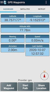
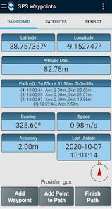
- በትክክለኛው እና በአሰሳ መረጃ የአሁኑን ቦታ ያግኙ ፣
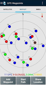
- የነቃ እና የሚታዩ ሳተላይቶች ዝርዝሮችን ያቅርቡ (ጂፒኤስ ፣ GLONASS ፣ GALILEO ፣ BEIDOU እና ሌሎች);
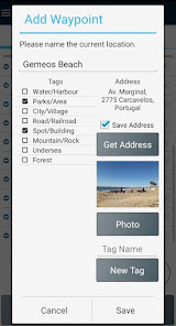
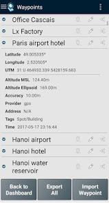
- በትክክለኛ መረጃ ነጥቦችን ይፍጠሩ ፣ በመለያዎች ይመድቧቸው ፣ ፎቶዎችን ያያይዙ እና መጋጠሚያዎችን ወደ ሰው ሊነበብ ወደሚችል አድራሻ (ወደኋላ መለወጥ)
- ነጥቦችን ከጂኦግራፊያዊ መጋጠሚያዎች (ላቲ ፣ ረጅም) ወይም የጎዳና አድራሻ/የፍላጎት ነጥብ (ጂኦኮዲንግ) በመፈለግ ያስመጡ።
- የነጥቦችን ቅደም ተከተሎች በእጅ ወይም በራስ -ሰር በማግኘት ዱካዎችን ይፍጠሩ ፣
- ከነባር ነጥቦች ዱካዎችን ያስመጡ ፤
- ነጥቦችን እና ዱካዎችን ለመመደብ በብጁ መለያዎች የዳሰሳ ጥናት ገጽታዎችን ይፍጠሩ
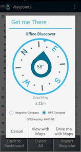
- መግነጢሳዊ ወይም ጂፒኤስ ኮምፓስን በመጠቀም ከአሁኑ አቀማመጥ ወደ ነጥቦች እና ዱካዎች አቅጣጫዎችን እና ርቀቶችን ያግኙ ፤
- ነጥቦችን እና ዱካዎችን ወደ KML እና GPX ፋይል ቅርጸት ይላኩ ፤
- ለሌሎች መተግበሪያዎች (ለምሳሌ Dropbox/Google Drive) ውሂብ ያጋሩ ፤
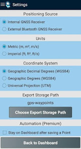
- ለውስጠኛው ተቀባይ ወይም የውጭ ተቀባይን በመጠቀም የአቀማመጥ ምንጭን ያዋቅሩ።
ፕሪሚየም የደንበኝነት ምዝገባ የሚከተሉትን የባለሙያ ባህሪዎች ያካትታል
- የተጠቃሚን ውሂብ መጠባበቂያ እና ወደነበረበት ይመልሱ (እንዲሁም ከአንድ ስልክ ወደ ሌላ ማስተላለፍ ውሂብን ይፈቅዳል) ፤
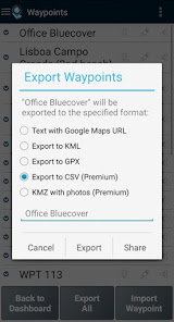
- የመንገድ ነጥቦችን እና ዱካዎችን ወደ CSV ፋይል ቅርጸት ይላኩ ፤
- የመንገድ ነጥቦችን በፎቶዎች ወደ KMZ ፋይል ይላኩ
- ከ CSV እና GPX ፋይሎች በርካታ ነጥቦችን እና መንገዶችን ያስመጡ ፤
- ነጥቦችን እና መንገዶችን በፍጥረት ጊዜ ፣ ስም እና ቅርበት ደርድር እና አጣራ ፤
- የሳተላይት ምልክት ትንተና እና ጣልቃ ገብነቶች መለየት።
የካርታዎች ባህሪው ነጥቦችዎን ፣ ዱካዎችዎን እና ፖሊጎኖቹን በክፍት የመንገድ ካርታዎች ላይ ለመምረጥ እና በዓይነ ሕሊናዎ ለመመልከት የሚያስችል ተጨማሪ የተከፈለ Funcionality ነው።
ከውስጣዊው የሞባይል መቀበያ በተጨማሪ ፣ የአሁኑ ስሪት ከሚከተሉት ውጫዊ ተቀባዮች ጋር አብሮ እንደሚሠራ ይታወቃል - መጥፎ ኤልፍ ጂኤንኤስኤስ ተቆጣጣሪ; ጋርሚን ግሎ; Navilock BT-821G; Qstarz BT-Q818XT; Trimple R1; ublox F9P።
በሌላ የውጭ መቀበያ መተግበሪያውን በተሳካ ሁኔታ ከሞከሩ እባክዎን ይህንን ዝርዝር ለማራዘም ግብረመልስዎን እንደ ተጠቃሚ ወይም አምራች ያቅርቡልን።
ለተጨማሪ መረጃ ጣቢያችንን (https://www.bluecover.pt/gps-waypoints) ይመልከቱ እና የተሟላ አቅርቦታችንን ዝርዝሮች ያግኙ-
- ነፃ እና ፕሪሚየም ባህሪዎች (https://www.bluecover.pt/gps-waypoints/features)
-GISUY ተቀባዮች (https://www.bluecover.pt/gisuy-gnss-receiver/)
-ድርጅት (https://www.bluecover.pt/gps-waypoints/enterprise-version/)
መተግበሪያው የካርታ እና የቅየሳ እንቅስቃሴዎችን ለማከናወን ነጥቦችን (እንደ የፍላጎት ነጥቦች) እና ዱካዎች (የነጥቦች ቅደም ተከተል) ይሰበስባል። በትክክለኛ መረጃ የተገኙ ነጥቦች ፣ በተወሰኑ መለያዎች ወይም በፎቶዎች ተለይተው በተጠቃሚው ሊመደቡ ይችላሉ። ዱካዎቹ እንደ አዲስ የተገኙ ነጥቦች ጊዜያዊ ቅደም ተከተል (ለምሳሌ ትራክ ለመቅዳት) ወይም በአማራጭ ከነባር ነጥቦች (ለምሳሌ መንገድ ለመፍጠር) የተፈጠሩ ናቸው። ዱካዎች ርቀቶችን ለመለካት እና ከተዘጋ ፣ የቦታዎችን እና ዙሪያዎችን ለመወሰን የሚያስችሉ ፖሊጎኖችን ይፈጥራል። ሁለቱም ነጥቦች እና ዱካዎች ወደ KML ፣ GPX እና CSV ፋይል ወደ ውጭ መላክ እና ስለሆነም በጂኦግራፊያዊ መሣሪያ ከውጭ ሊሠሩ ይችላሉ።
መተግበሪያው ውስጣዊ የጂፒኤስ መቀበያውን ከሞባይል መሳሪያው (በተለምዶ ከትክክለኛነት> 3 ሜ) ይጠቀማል ወይም እንደ አማራጭ ከኤንኤኤኤኤኤኤኤኤኤኤኤኤኤኤኤኤኤኤኤኤኤኤኤኤኤኤኤኤኤኤኤኤኤኤኤኤኤኤኤኤኤኤኤኤኤኤኤኤኤኤኤኤኤኤኤኤኤኤኤኤኤኤኤኤኤኤኤኤኤኤኤኤኤኤኤኤኤኤኤኤኤኤኤኤኤኤኤኤኤኤኤኤኤኤኤኤኤኤኤኤኤኤኤኤኤኤኤኤኤኤኤኤኤኤኤኤኤኤቲኤቲ ደረጃ ደረጃ ትክክለኛነት ጋር)። የውጭ ተቀባዮች የሚደገፉ አንዳንድ ምሳሌዎችን ከዚህ በታች ይመልከቱ።
ማመልከቻው የሚከተሉትን ባህሪዎች ያጠቃልላል
- በትክክለኛው እና በአሰሳ መረጃ የአሁኑን ቦታ ያግኙ ፣
- የነቃ እና የሚታዩ ሳተላይቶች ዝርዝሮችን ያቅርቡ (ጂፒኤስ ፣ GLONASS ፣ GALILEO ፣ BEIDOU እና ሌሎች);
- በትክክለኛ መረጃ ነጥቦችን ይፍጠሩ ፣ በመለያዎች ይመድቧቸው ፣ ፎቶዎችን ያያይዙ እና መጋጠሚያዎችን ወደ ሰው ሊነበብ ወደሚችል አድራሻ (ወደኋላ መለወጥ)
- ነጥቦችን ከጂኦግራፊያዊ መጋጠሚያዎች (ላቲ ፣ ረጅም) ወይም የጎዳና አድራሻ/የፍላጎት ነጥብ (ጂኦኮዲንግ) በመፈለግ ያስመጡ።
- የነጥቦችን ቅደም ተከተሎች በእጅ ወይም በራስ -ሰር በማግኘት ዱካዎችን ይፍጠሩ ፣
- ከነባር ነጥቦች ዱካዎችን ያስመጡ ፤
- ነጥቦችን እና ዱካዎችን ለመመደብ በብጁ መለያዎች የዳሰሳ ጥናት ገጽታዎችን ይፍጠሩ
- መግነጢሳዊ ወይም ጂፒኤስ ኮምፓስን በመጠቀም ከአሁኑ አቀማመጥ ወደ ነጥቦች እና ዱካዎች አቅጣጫዎችን እና ርቀቶችን ያግኙ ፤
- ነጥቦችን እና ዱካዎችን ወደ KML እና GPX ፋይል ቅርጸት ይላኩ ፤
- ለሌሎች መተግበሪያዎች (ለምሳሌ Dropbox/Google Drive) ውሂብ ያጋሩ ፤
- ለውስጠኛው ተቀባይ ወይም የውጭ ተቀባይን በመጠቀም የአቀማመጥ ምንጭን ያዋቅሩ።
ፕሪሚየም የደንበኝነት ምዝገባ የሚከተሉትን የባለሙያ ባህሪዎች ያካትታል
- የተጠቃሚን ውሂብ መጠባበቂያ እና ወደነበረበት ይመልሱ (እንዲሁም ከአንድ ስልክ ወደ ሌላ ማስተላለፍ ውሂብን ይፈቅዳል) ፤
- የመንገድ ነጥቦችን እና ዱካዎችን ወደ CSV ፋይል ቅርጸት ይላኩ ፤
- የመንገድ ነጥቦችን በፎቶዎች ወደ KMZ ፋይል ይላኩ
- ከ CSV እና GPX ፋይሎች በርካታ ነጥቦችን እና መንገዶችን ያስመጡ ፤
- ነጥቦችን እና መንገዶችን በፍጥረት ጊዜ ፣ ስም እና ቅርበት ደርድር እና አጣራ ፤
- የሳተላይት ምልክት ትንተና እና ጣልቃ ገብነቶች መለየት።
የካርታዎች ባህሪው ነጥቦችዎን ፣ ዱካዎችዎን እና ፖሊጎኖቹን በክፍት የመንገድ ካርታዎች ላይ ለመምረጥ እና በዓይነ ሕሊናዎ ለመመልከት የሚያስችል ተጨማሪ የተከፈለ Funcionality ነው።
ከውስጣዊው የሞባይል መቀበያ በተጨማሪ ፣ የአሁኑ ስሪት ከሚከተሉት ውጫዊ ተቀባዮች ጋር አብሮ እንደሚሠራ ይታወቃል - መጥፎ ኤልፍ ጂኤንኤስኤስ ተቆጣጣሪ; ጋርሚን ግሎ; Navilock BT-821G; Qstarz BT-Q818XT; Trimple R1; ublox F9P።
በሌላ የውጭ መቀበያ መተግበሪያውን በተሳካ ሁኔታ ከሞከሩ እባክዎን ይህንን ዝርዝር ለማራዘም ግብረመልስዎን እንደ ተጠቃሚ ወይም አምራች ያቅርቡልን።
ለተጨማሪ መረጃ ጣቢያችንን (https://www.bluecover.pt/gps-waypoints) ይመልከቱ እና የተሟላ አቅርቦታችንን ዝርዝሮች ያግኙ-
- ነፃ እና ፕሪሚየም ባህሪዎች (https://www.bluecover.pt/gps-waypoints/features)
-GISUY ተቀባዮች (https://www.bluecover.pt/gisuy-gnss-receiver/)
-ድርጅት (https://www.bluecover.pt/gps-waypoints/enterprise-version/)
የተዘመነው በ


ደረጃዎች እና ግምገማዎች
3.9
1.67 ሺ ግምገማዎች
ምን አዲስ ነገር አለ
Version 3.15
- Add manual Points and draw Paths on Maps
- Ruler on Maps
- Share Web URL with photos
- Produce line charts in time from Paths with multi-selection
- Add Point based on multi GNSS acquisitions from external receivers
- Edit Path improvements
- Various fixes, including Exports in Android 8 e 9
Version 3.14
- Add and Edit Waypoints with multi-photos support and a new photo viewer
- Edit Points from Path
- Share Paths via Geodata Map Viewer
የመተግበሪያ ድጋፍ
phone
ስልክ ቁጥር:
+351932526378
ስለገንቢው
BLUECOVER - TECHNOLOGIES, LDA
info@bluecover.pt
AVENIDA DO BRASIL, 1 1ºESQ.
7300-068 PORTALEGRE (PORTALEGRE )
Portugal
+351 932 526 378


