
Geotag Photos with GPS Stamps
Contains adsIn-app purchases

3.7star
781 reviews
100K+
Downloads

Everyone
info


About this app
Geotag Stamp Camera – The ultimate Geotagging Photo Camera for all your professional work reports!📌
📸 Capture. 🌍 Geotag. 🗂️ Report.
Take geotag photos with live GPS location and latitude-longitude using our Geotagging Photos app. Auto-add accurate geotags, timestamps, and location info to your photos and videos. Whether for fieldwork, engineering, transportation, or travel, Geotag Camera ensures every photo includes essential location details with latitude/longitude.
⭐Capture Work Reports Instantly with Pre-Built Templates:
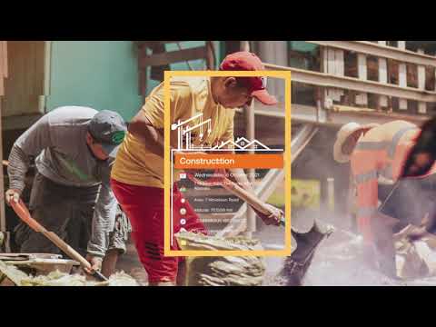
🔰Service Stamps: Perfect for tracking deliveries, tasks, and operations by capturing geotagged photos with precise timestamps and photos with location details.
🔰Field Stamps: Ideal for documenting outdoor projects, surveys, and site inspections, ensuring every geotag photo includes accurate geotag and timestamp information.
🔰Office Stamps: Useful for meetings, attendance tracking, and work records with customizable templates for geotagging photos and adding photos with location details.
⭐Main Stamp Fields in Geotag Photos & GPS Stamp Camera app include:
💠Logo: Add your brand/logo to photos for identification.
✒️Subject: Tag geotag photos with specific project names or categories.
🗓️Date Format: Customize date format (DD/MM/YYYY, etc.).
📍Location: Geotag photos with GPS coordinates & location.
🗺️Area: Record work area details for documentation.
🏔️Altitude: Capture altitude data for location precision.
🧭Compass: Include compass direction for orientation.
🌐Coordinates: Automatically add latitude-longitude for photo geotagging.
🌡️Temperature: Tag photos with current temperature details.
🌬️Wind Force: Document wind speed for environmental conditions.
🍃Air Quality: Capture air quality data for environmental checks.
👷Contractor: Tag photos with contractor details for accountability.
👨💼Supervisor: Document supervisor info for project oversight.
👨🏻🔧Worker: Identify workers captured in Geotag pictures.
📝Note: Add geo notes for additional context to geo-tagged photo.
⭐Geotagging Photos app for Every Need – Fieldwork, Travel, Office & More:
✔️Fieldwork Documentation
-Capture detailed photos with geotag and GPS camera with time stamp for surveying, construction, and land management.
✔️Engineering Work
-Track project progress with geotagging photos and documenting construction phases and technical details.
✔️Office Work & Meetings
-Capture meeting details, track attendance, and clock in/out times with geotagging photos app.
✔️Transportation & Delivery
-Document deliveries, monitor routes, and verify task completion with GPS Mapping Camera.
✔️Travel & Adventure
-Easily document journeys, capture moments and share adventures with geotagged photos.
✔️Work Reporting & Project Management
-Create detailed reports with geotagging photos to track progress and manage projects.
Auto Geotag Camera with GPS Stamps is perfect for professionals in various fields. Capture every detail with accurate location and time tagging to improve your geotagging photos app documentation and reporting.
📲 Download Geotag Photos with GPS Stamp Location Now!
📸 Capture. 🌍 Geotag. 🗂️ Report.
Take geotag photos with live GPS location and latitude-longitude using our Geotagging Photos app. Auto-add accurate geotags, timestamps, and location info to your photos and videos. Whether for fieldwork, engineering, transportation, or travel, Geotag Camera ensures every photo includes essential location details with latitude/longitude.
⭐Capture Work Reports Instantly with Pre-Built Templates:
🔰Service Stamps: Perfect for tracking deliveries, tasks, and operations by capturing geotagged photos with precise timestamps and photos with location details.
🔰Field Stamps: Ideal for documenting outdoor projects, surveys, and site inspections, ensuring every geotag photo includes accurate geotag and timestamp information.
🔰Office Stamps: Useful for meetings, attendance tracking, and work records with customizable templates for geotagging photos and adding photos with location details.
⭐Main Stamp Fields in Geotag Photos & GPS Stamp Camera app include:
💠Logo: Add your brand/logo to photos for identification.
✒️Subject: Tag geotag photos with specific project names or categories.
🗓️Date Format: Customize date format (DD/MM/YYYY, etc.).
📍Location: Geotag photos with GPS coordinates & location.
🗺️Area: Record work area details for documentation.
🏔️Altitude: Capture altitude data for location precision.
🧭Compass: Include compass direction for orientation.
🌐Coordinates: Automatically add latitude-longitude for photo geotagging.
🌡️Temperature: Tag photos with current temperature details.
🌬️Wind Force: Document wind speed for environmental conditions.
🍃Air Quality: Capture air quality data for environmental checks.
👷Contractor: Tag photos with contractor details for accountability.
👨💼Supervisor: Document supervisor info for project oversight.
👨🏻🔧Worker: Identify workers captured in Geotag pictures.
📝Note: Add geo notes for additional context to geo-tagged photo.
⭐Geotagging Photos app for Every Need – Fieldwork, Travel, Office & More:
✔️Fieldwork Documentation
-Capture detailed photos with geotag and GPS camera with time stamp for surveying, construction, and land management.
✔️Engineering Work
-Track project progress with geotagging photos and documenting construction phases and technical details.
✔️Office Work & Meetings
-Capture meeting details, track attendance, and clock in/out times with geotagging photos app.
✔️Transportation & Delivery
-Document deliveries, monitor routes, and verify task completion with GPS Mapping Camera.
✔️Travel & Adventure
-Easily document journeys, capture moments and share adventures with geotagged photos.
✔️Work Reporting & Project Management
-Create detailed reports with geotagging photos to track progress and manage projects.
Auto Geotag Camera with GPS Stamps is perfect for professionals in various fields. Capture every detail with accurate location and time tagging to improve your geotagging photos app documentation and reporting.
📲 Download Geotag Photos with GPS Stamp Location Now!
Updated on
Safety starts with understanding how developers collect and share your data. Data privacy and security practices may vary based on your use, region and age. The developer provided this information and may update it over time.

This app may share these data types with third parties
Location

No data collected
Learn more about how developers declare collection

Data is encrypted in transit

Data can’t be deleted
Ratings and reviews
4.2
774 reviews

Kartik Makwana
- Flag inappropriate
26 November 2021
Amazing..!!😍 application for personal and business use. And must say very intuitive and easy to use. It has impressive free templates to create your watermark with full range of editing details. I would recommend it.👍
65 people found this review helpful
Master Apps Lab
17 June 2024
Dear friend, we are really glad that you like our time stamp watermark app. Keep using!

Neel Shah
- Flag inappropriate
14 February 2022
Amazing .. !! application for personal and business use . And must say very intuitive and easy to use . It has impressive free templates to create your watermark with full range of editing details . I would recommend it .
43 people found this review helpful
Master Apps Lab
17 June 2024
Thank you for your positive feedback. We are delighted to have been able to assist you. Any suggestions are welcome :)

Last Soldier
- Flag inappropriate
12 February 2022
I love the templates this app provides. All templates are very good. I use the office template a lot when I am in a meeting or registering in and out times. Nice work done by developers.
41 people found this review helpful
Master Apps Lab
17 June 2024
Thank you for your encouraging words. Keep using app!
App support
About the developer
SUSAMP INFOTECH
appsupport@susampinfotech.com
4th Floor, Shop No. 412 To 421, Parle Square, Ved Gurukul Road
Opp. Akshar Wadi, Dabholi
Surat, Gujarat 395004
India
+91 94996 35045


