

OilTrails
Куплі ў праграме

10 тыс.+
Спампоўванні

Для ўсіх
info


Пра гэту праграму
*OilTrails requires a subscription, but new subscriptions come with a 1 month, no obligation, free trial.
Find oil and gas locations across the US with ease. Get turn-by-turn directions, view well data, weather forecasts, drop pins to see location name, and share well info and location coordinates with OilTrails. The only app that combines all these features with a simple yet powerful interface.
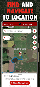
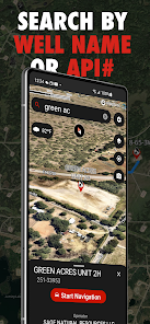
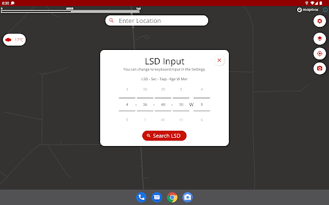
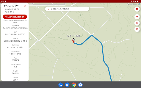
This multifunctional lease locator app makes getting to work in the oilfield a breeze. Simply enter the legal land description, name, or API number to view the surface location OR drop a pin on the map to view location and well info (if vertical). The location can be opened in Apple or Google maps for turn by turn navigation. Change the origin location to see step-by-step directions to location from the nearest town, useful for putting together ERPs or providing visitors directions.
No cell service? No problem. As long as turn by turn navigation is started before service is lost, the directions will continue to function so you don't have to worry about being stranded halfway to location.
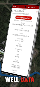
Enter a location and view well information such as the operating company, depth, drill date, current status, downhole fluid, formation, and more. Data varies depending on the region.
See the current, future AND past weather specific to the location entered. Wondering if the lease is too wet or has snow to be cleared? View the precipitation the location was forecasted to receive in the past three days. Scroll for 48 hrs of hourly forecasts, 7 daily forecasts, and previous forecasts.
Drop a pin on the map to see the location and well info for that location.
View history of past locations viewed and date they were looked up. Makes driving logs and reports a breeze by knowing where and when you were. Create an account to save and sync locations between devices.
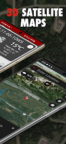
Maps can be shown in a variety of ways including Topographical, 3D Satellite, 2D Satellite, Dark Roads, and Light Roads.
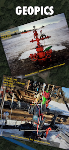
Take GeoPics, geographical and date/time stamped photos that you can save to your device or share.
-Turn by turn GPS navigation in Google Maps
-Enter downhole location to view well info such as the operating company, depth, drill date, current status, -downhole fluid
-View the current weather at location as well as hourly and daily forecast AND previous forecasts to see if the location has received rain/snow is the past three days
-See location in app and view with standard, hybrid, or 3D satellite imagery
-Store history of previously viewed wells/locations
-Share location and well info via message
-Drop pins on the map to see that location's LSD and well info
-International support, find wells in the United States and Australia
Find oil and gas locations across the US with ease. Get turn-by-turn directions, view well data, weather forecasts, drop pins to see location name, and share well info and location coordinates with OilTrails. The only app that combines all these features with a simple yet powerful interface.
This multifunctional lease locator app makes getting to work in the oilfield a breeze. Simply enter the legal land description, name, or API number to view the surface location OR drop a pin on the map to view location and well info (if vertical). The location can be opened in Apple or Google maps for turn by turn navigation. Change the origin location to see step-by-step directions to location from the nearest town, useful for putting together ERPs or providing visitors directions.
No cell service? No problem. As long as turn by turn navigation is started before service is lost, the directions will continue to function so you don't have to worry about being stranded halfway to location.
Enter a location and view well information such as the operating company, depth, drill date, current status, downhole fluid, formation, and more. Data varies depending on the region.
See the current, future AND past weather specific to the location entered. Wondering if the lease is too wet or has snow to be cleared? View the precipitation the location was forecasted to receive in the past three days. Scroll for 48 hrs of hourly forecasts, 7 daily forecasts, and previous forecasts.
Drop a pin on the map to see the location and well info for that location.
View history of past locations viewed and date they were looked up. Makes driving logs and reports a breeze by knowing where and when you were. Create an account to save and sync locations between devices.
Maps can be shown in a variety of ways including Topographical, 3D Satellite, 2D Satellite, Dark Roads, and Light Roads.
Take GeoPics, geographical and date/time stamped photos that you can save to your device or share.
-Turn by turn GPS navigation in Google Maps
-Enter downhole location to view well info such as the operating company, depth, drill date, current status, -downhole fluid
-View the current weather at location as well as hourly and daily forecast AND previous forecasts to see if the location has received rain/snow is the past three days
-See location in app and view with standard, hybrid, or 3D satellite imagery
-Store history of previously viewed wells/locations
-Share location and well info via message
-Drop pins on the map to see that location's LSD and well info
-International support, find wells in the United States and Australia
Абноўлена
Бяспека пачынаецца з разумення таго, як распрацоўшчыкі збіраюць і абагульваюць вашы даныя. Спосабы забеспячэння прыватнасці і бяспекі даных залежаць ад выкарыстання праграмы, месца пражывання і ўзросту карыстальніка. Распрацоўшчык даў гэту інфармацыю, але з цягам часу ён можа змяніць яе.

Гэта праграма можа абагульваць наступныя тыпы даных з трэцімі бакамі:
Месцазнаходжанне і Фінансавая інфармацыя

Праграма можа збіраць наступныя тыпы даных:
Асабістая інфармацыя, Інфармацыя пра праграмы і іх прадукцыйнасць і Прылада ці іншыя ідэнтыфікатары

Даныя перадаюцца ў зашыфраваным выглядзе

Вы можаце запытаць выдаленне даных
Што новага
-Reverse Geocode Hotfix
- Minor performance improvements and stability fixes
- Minor performance improvements and stability fixes
Служба падтрымкі для праграмы
Пра распрацоўшчыка
Ash Point Ltd
contact@ashpoint.ca
20 Reid Crt
Sylvan Lake, AB T4S 0L9
Canada
+1 587-200-2400

