Quy Hoạch Thái Bình
Contains adsIn-app purchases
5K+
Downloads

Everyone
info
About this app
Main functions of the application:
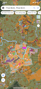
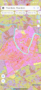
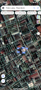
1. View the 2030 land use planning map, construction planning.
2. Locate the user's current land plot to see if it is included in the planning area.
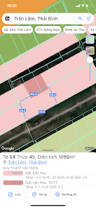
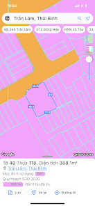
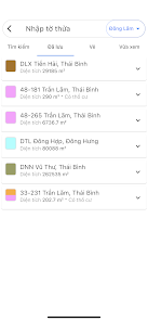
3. Look up land plot information by:
• Enter the sheet number and plot number.
• Enter the coordinate information of the land plot.
• Click directly on the map.
4. Pin land plot information to view later and view on another device.
5. Draw the land plot.
DISCLAIMER:
The application does not represent any government agency
All information on the application is for reference only and has no legal value.
DATA SOURCE:
Hung Yen Department of Construction: https://soxaydung.hungyen.gov.vn/chuyen-muc-thong-tin-quy-hoach-c237-1.html
Hung Yen Information Portal: https://hungyen.gov.vn/chuyen-muc-nong-nghiep-nong-thon-c29-1.html
1. View the 2030 land use planning map, construction planning.
2. Locate the user's current land plot to see if it is included in the planning area.
3. Look up land plot information by:
• Enter the sheet number and plot number.
• Enter the coordinate information of the land plot.
• Click directly on the map.
4. Pin land plot information to view later and view on another device.
5. Draw the land plot.
DISCLAIMER:
The application does not represent any government agency
All information on the application is for reference only and has no legal value.
DATA SOURCE:
Hung Yen Department of Construction: https://soxaydung.hungyen.gov.vn/chuyen-muc-thong-tin-quy-hoach-c237-1.html
Hung Yen Information Portal: https://hungyen.gov.vn/chuyen-muc-nong-nghiep-nong-thon-c29-1.html
Updated on
Safety starts with understanding how developers collect and share your data. Data privacy and security practices may vary based on your use, region, and age. The developer provided this information and may update it over time.

This app may share these data types with third parties
Photos and videos

No data collected
Learn more about how developers declare collection

Data is encrypted in transit

You can request that data be deleted
What’s new
Tinh chỉnh giao diện.
App support
About the developer
Phạm Khánh Phương
road.radar.us@gmail.com
Tổ 13, Ấp An Viễng, Bình An
Long Thành
Đồng Nai 76207
Vietnam
undefined


