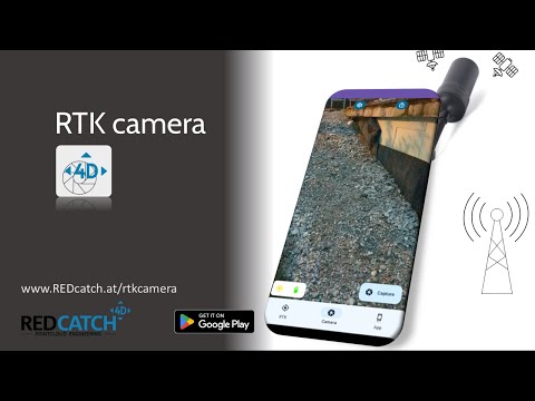
RTK camera - 3D geotag scanner
Achats via l'appli

1K+
Téléchargements

Tout public
info


À propos de l'application
RTK camera is an All-In-One NTRIP and Camera App, to take centimeter accurate geotagged photos and logging the path you've walked.
There are 3 modes of taking photos:
- automatic 3D tracker (for photogrammetry)
- time laps
- single shoot
You can connect ANY external GNSS chip device using (normal) Bluetooth or USB.
Highlights:
- It's save an easy to use.
- No Cloud. Data is yours!
- NO Developer Mode and NO Mock Location required
- FREE Logging of GNSS track in NMEA style with GNGGA, GNRMC and GNGST message
- NTRIP client integrated
- Full-resolution, geotagged photos (subscription required)
- Coordinates are directly written into EXIF/XMP
- USB connection (serial usb is not recommended)
- Bluetooth connections supported (no Bluetooth LE support!)
Date de mise à jour
La sécurité, c'est d'abord comprendre comment les développeurs collectent et partagent vos données. Les pratiques concernant leur confidentialité et leur protection peuvent varier selon votre utilisation, votre région et votre âge. Le développeur a fourni ces informations et peut les modifier ultérieurement.

Aucune donnée partagée avec des tiers
En savoir plus sur la manière dont les développeurs déclarent le partage

Aucune donnée collectée
En savoir plus sur la manière dont les développeurs déclarent la collecte
Nouveautés
Added a map for seeing the current position and traveled path for the current session
Cleaned up UI
Removed output format selection, all output formats for your subscription status will always be created
Fixed edge case crash regarding BT search
Fixed small UI bugs
Cleaned up UI
Removed output format selection, all output formats for your subscription status will always be created
Fixed edge case crash regarding BT search
Fixed small UI bugs
Assistance de l'appli
phone
Numéro de téléphone
+436607305038
À propos du développeur
REDcatch GmbH
support@redcatch.at
Tschaffinis Umgebung 14
6166 Fulpmes
Austria
+43 660 7305038