
Sundial Atlas Mobile
1K+
Téléchargements

Tout public
info


À propos de l'application
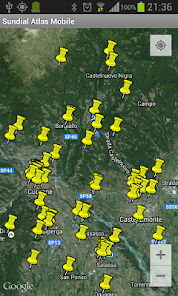
The program shows the map of the country around your position, it then makes access to the data base of Sundial Atlas (www.sundialatlas.eu) and it downloads all the sundials that are present in the map that is shown on the display.
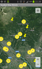
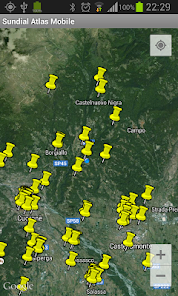
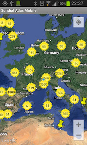
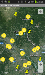
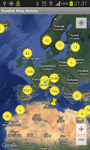
Each sundial is represented by an icon on the place where it is installed (if the icons are more than 200 then the app collects them under a single icon in order to avoid the user interface slowing down).
The map can be dragged and zoomed.
A find command can be used to show the map around a desired known place.
Sundials downloaded from internet are stored in a local data base.
Therefore when an internet connection is not available, or the user denies the permission to use it by means of the dedicated option in the preferences, it is still possible to explore the map.
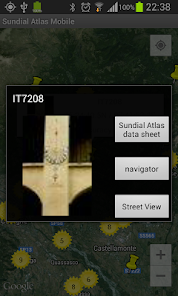
A click on a sundial icon opens a window where a low resolution image of the sundial (just downloaded from internet if available) is shown together with its ID (f.i. IT3979), its geograpic coordinates and its location precision as declared when registered to Sundial Atlas.
A click on this window opens a dialog where, together with a medium resolution image of the sundial (if a connection is available), the following commands are available:
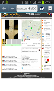
- "Sundial Atlas data sheet" shows the sundial data sheet in the Sundial Atlas site using the predefined browser
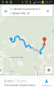
- "navigator" opens the navigator with the sundial coordinates as the destination
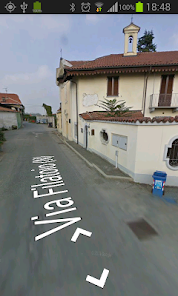
- "Street View" opens Street View on the sundial place
A menu command shows some statistic information about the local data base and the map that is shown on the display.
Sundial Atlas Mobile needs the following permissions:
- network connession for maps and sundials download
- GPS localization
IMPORTANT
If you have any problem with this app please let me know what's happening !
This is the only way for me to be informed and try to solve the problem (this app supports more than 5000 devices, I cannot test it on everyone !)
You can send me an e-mail. Or you can authorize the transmission of the report log that is automatically created by Android when an app crashes: this report is completely anonymous.
More information on the program are available from the author's site:
http://digilander.libero.it/orologi.solari
From this same site a complete free program for sundial design and simulation is available (Windows only).
Other apps from the same author: SolEtUmbra shows the sun ephemerides, shows a sundial as computed on the plane that contains the device display, shows the path of the sun in the sky.
The author can be contacted at the address:
gian.casalegno@gmail.com
Sundial Atlas Mobile develoment has been made possible through the s/w code that Fabio Savian has developed on the server side.
Each sundial is represented by an icon on the place where it is installed (if the icons are more than 200 then the app collects them under a single icon in order to avoid the user interface slowing down).
The map can be dragged and zoomed.
A find command can be used to show the map around a desired known place.
Sundials downloaded from internet are stored in a local data base.
Therefore when an internet connection is not available, or the user denies the permission to use it by means of the dedicated option in the preferences, it is still possible to explore the map.
A click on a sundial icon opens a window where a low resolution image of the sundial (just downloaded from internet if available) is shown together with its ID (f.i. IT3979), its geograpic coordinates and its location precision as declared when registered to Sundial Atlas.
A click on this window opens a dialog where, together with a medium resolution image of the sundial (if a connection is available), the following commands are available:
- "Sundial Atlas data sheet" shows the sundial data sheet in the Sundial Atlas site using the predefined browser
- "navigator" opens the navigator with the sundial coordinates as the destination
- "Street View" opens Street View on the sundial place
A menu command shows some statistic information about the local data base and the map that is shown on the display.
Sundial Atlas Mobile needs the following permissions:
- network connession for maps and sundials download
- GPS localization
IMPORTANT
If you have any problem with this app please let me know what's happening !
This is the only way for me to be informed and try to solve the problem (this app supports more than 5000 devices, I cannot test it on everyone !)
You can send me an e-mail. Or you can authorize the transmission of the report log that is automatically created by Android when an app crashes: this report is completely anonymous.
More information on the program are available from the author's site:
http://digilander.libero.it/orologi.solari
From this same site a complete free program for sundial design and simulation is available (Windows only).
Other apps from the same author: SolEtUmbra shows the sun ephemerides, shows a sundial as computed on the plane that contains the device display, shows the path of the sun in the sky.
The author can be contacted at the address:
gian.casalegno@gmail.com
Sundial Atlas Mobile develoment has been made possible through the s/w code that Fabio Savian has developed on the server side.
Date de mise à jour
La sécurité, c'est d'abord comprendre comment les développeurs collectent et partagent vos données. Les pratiques concernant leur confidentialité et leur protection peuvent varier selon votre utilisation, votre région et votre âge. Le développeur a fourni ces informations et peut les modifier ultérieurement.

Aucune donnée partagée avec des tiers
En savoir plus sur la manière dont les développeurs déclarent le partage

Aucune donnée collectée
En savoir plus sur la manière dont les développeurs déclarent la collecte
Nouveautés
updated with changes introduced to the Sundial Atlas website
Assistance de l'appli
À propos du développeur
Casalegno Gianpiero Maria
gian.casalegno@gmail.com
Italy
undefined


