Altura del rio
4.3star
1.55K reviews
10K+
Downloads

Everyone
info


About this app
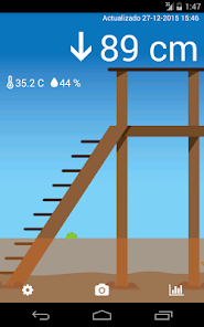
Find out about the status of the river live, river height, temperature, wind, tides and more
TIDE STATIONS 📏:
- In Rio Lujan and Canal Arias very close to Villa la Ñata and Dique Lujan
- In the Port of San Isidro
REPORTS HEIGHT OF THE RIO DE LA PLATA:
- Delta first section
- San Isidro
- San Fernando
- Buenos Aires
- La Plata
- and Pilote Norden
WIDGET: You can see the height of the river for the initial screen
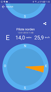
WIND ⛵️💨🌬 the wind in real time at Sunset Point, Club Avellaneda in San Isidro, Windguru station in San Isidro, La Plata and Pilote NORDEN.
SHN Naval Hydrography Service Tidal Forecast
Alert and notification 🌊🔥 when the Pleamar forecast exceeds a certain level.
Alert and notification by river level live
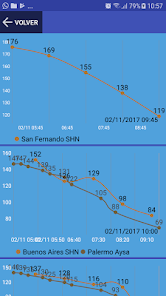
GRAPHICS 📈📉
- Historical river height for 24 hours
- Historical Forecast and tide
NEW:
Tide Table in San Fernando
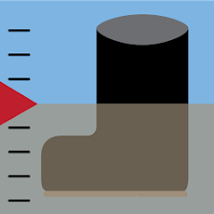
The measurement is made with our digital tide gauge located near the confluence of Rio Lujan and Canal Arias and the level is shown in centimeters using the same reference as the prefecture hydrometer of Dique Lujan.
Current TEMPERATURE AND HUMIDITY in the Delta.
An arrow 🔝 indicates the upward or downward trend.
Fish 🐟 and plants 🍀 move with the current of the river. If you go left the river goes down and to the right it rises.
PHOTOS 📷 with the information superimposed to share
Set an alert level to receive a notification on your phone when the river exceeds that level
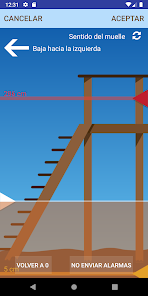
Adapt the water level shown to the actual spring
Change the direction of the spring and / or change the direction of the current.
Share the image of the dock and the current data!
By knowing the height of the real river and live you can know:
- If there is water in the park of the house or if it covers the dock
- If it is possible to enter the canal due to lack of water
- You cannot leave the marina due to lack of water
- Are the streets of Tigre and Rincon de Milberg beginning to flood?
- Good bite to fish? 🦈
- Is it nice to row? 🛶🚣♂️
- Can you navigate outside the canal? ⛵️
PROBLEMS, DOUBTS? We respond at buglandapp@gmail.com for any opinion, suggestion or error!
User manual: https://www.alturadelrio.com/manual
Instagram: https://www.instagram.com/alturadelrio/
TIDE STATIONS 📏:
- In Rio Lujan and Canal Arias very close to Villa la Ñata and Dique Lujan
- In the Port of San Isidro
REPORTS HEIGHT OF THE RIO DE LA PLATA:
- Delta first section
- San Isidro
- San Fernando
- Buenos Aires
- La Plata
- and Pilote Norden
WIDGET: You can see the height of the river for the initial screen
WIND ⛵️💨🌬 the wind in real time at Sunset Point, Club Avellaneda in San Isidro, Windguru station in San Isidro, La Plata and Pilote NORDEN.
SHN Naval Hydrography Service Tidal Forecast
Alert and notification 🌊🔥 when the Pleamar forecast exceeds a certain level.
Alert and notification by river level live
GRAPHICS 📈📉
- Historical river height for 24 hours
- Historical Forecast and tide
NEW:
Tide Table in San Fernando
The measurement is made with our digital tide gauge located near the confluence of Rio Lujan and Canal Arias and the level is shown in centimeters using the same reference as the prefecture hydrometer of Dique Lujan.
Current TEMPERATURE AND HUMIDITY in the Delta.
An arrow 🔝 indicates the upward or downward trend.
Fish 🐟 and plants 🍀 move with the current of the river. If you go left the river goes down and to the right it rises.
PHOTOS 📷 with the information superimposed to share
Set an alert level to receive a notification on your phone when the river exceeds that level
Adapt the water level shown to the actual spring
Change the direction of the spring and / or change the direction of the current.
Share the image of the dock and the current data!
By knowing the height of the real river and live you can know:
- If there is water in the park of the house or if it covers the dock
- If it is possible to enter the canal due to lack of water
- You cannot leave the marina due to lack of water
- Are the streets of Tigre and Rincon de Milberg beginning to flood?
- Good bite to fish? 🦈
- Is it nice to row? 🛶🚣♂️
- Can you navigate outside the canal? ⛵️
PROBLEMS, DOUBTS? We respond at buglandapp@gmail.com for any opinion, suggestion or error!
User manual: https://www.alturadelrio.com/manual
Instagram: https://www.instagram.com/alturadelrio/
Updated on
Safety starts with understanding how developers collect and share your data. Data privacy and security practices may vary based on your use, region, and age. The developer provided this information and may update it over time.

No data shared with third parties
Learn more about how developers declare sharing

No data collected
Learn more about how developers declare collection
Ratings and reviews
4.3
1.53K reviews

Alberto Michelis
- Flag inappropriate
February 24, 2024
olivos para cuando?

Cosme Argerich
- Flag inappropriate
October 8, 2022
La App es muy básica, pero es útil y rápidamente se comprende el estado y tendencia de la marea. Utiliza una referencia gráfica (altura del agua expresada en los escalones de un muelle) tal como se usa en el Delta. No sé si tiene sentido hacerla mas compleja. Me suscribí a la versión paga 1 U$ BNA x mes y ahora puedo customizar algunas funciones.
1 person found this review helpful
mastra
November 27, 2016
Ahora informa el viento reportado por el Pilote Norden

A Google user
- Flag inappropriate
March 6, 2019
la estoy probando muy linda interfase
1 person found this review helpful