
HuKi - Hungarian Hiking App
4,8star
82 recenzijeinfo
10 hilj.+
Preuzimanja

PEGI 3
info
O aplikaciji
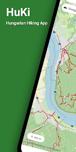
HuKi is an OpenStreetMap based hiking map for hikers and nature lovers, which uses the Hungarian hiking layer.
HuKi can be useful if you want to see the hiking trails nearby, you are planning a hike or want to do a hike based on a GPX track.
HuKi is my hobby project, I develop it in my free time and I'm happy to receive any feedback to make it more useful :)
huki.app@gmail.com
HuKi features:
- Hungarian hiking layer integration
The app uses the Hungarian hiking layer with the official hiking trails, and it is integrated with the base OpenStreetMap layers.
- Live location support
HuKi can show your actual position, elevation, orientation and location accuracy during your trip.
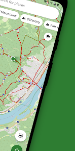
- Search for places
You can make text based searches for places or hiking routes.
- Explore landscapes
You can search in the main Hungarian landscapes like Bükk, Mátra, Balaton etc.
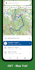
- OKT - National Blue Trail
HuKi can show the OKT - National Blue Trails for blue trail hikers. The imported OKT GPX can show the stamp locations as well.
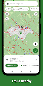
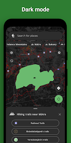
- Hiking routes nearby and hike recommendations
HuKi can show hike recommendations for landscapes and positions using the popular hiking collections.
It does not include built-in hike collections but any GPX track can be shown from articles and hike-collections.
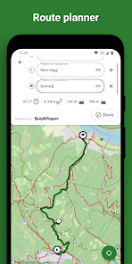
- Route planner
HuKi can be used to plan hiking routes. The planner always favors the official hiking trails.
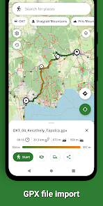
- GPX File import
HuKi can import and show GPX file tracks in the map.
Using the imported GPX track, the app shows the altitude profile, destinations and creates a travel time estimation.
- Offline mode
All of the visited parts of the map are saved in a database, which can be used offline.
The only thing to do, is to visit the desired parts in the map, when the app saves the tiles for 14 days.
- Dark mode support
- OpenSource project
HuKi is an OpenSource app, which can be found in GitHub:
https://github.com/RolandMostoha/HuKi-Android/
HuKi can be useful if you want to see the hiking trails nearby, you are planning a hike or want to do a hike based on a GPX track.
HuKi is my hobby project, I develop it in my free time and I'm happy to receive any feedback to make it more useful :)
huki.app@gmail.com
HuKi features:
- Hungarian hiking layer integration
The app uses the Hungarian hiking layer with the official hiking trails, and it is integrated with the base OpenStreetMap layers.
- Live location support
HuKi can show your actual position, elevation, orientation and location accuracy during your trip.
- Search for places
You can make text based searches for places or hiking routes.
- Explore landscapes
You can search in the main Hungarian landscapes like Bükk, Mátra, Balaton etc.
- OKT - National Blue Trail
HuKi can show the OKT - National Blue Trails for blue trail hikers. The imported OKT GPX can show the stamp locations as well.
- Hiking routes nearby and hike recommendations
HuKi can show hike recommendations for landscapes and positions using the popular hiking collections.
It does not include built-in hike collections but any GPX track can be shown from articles and hike-collections.
- Route planner
HuKi can be used to plan hiking routes. The planner always favors the official hiking trails.
- GPX File import
HuKi can import and show GPX file tracks in the map.
Using the imported GPX track, the app shows the altitude profile, destinations and creates a travel time estimation.
- Offline mode
All of the visited parts of the map are saved in a database, which can be used offline.
The only thing to do, is to visit the desired parts in the map, when the app saves the tiles for 14 days.
- Dark mode support
- OpenSource project
HuKi is an OpenSource app, which can be found in GitHub:
https://github.com/RolandMostoha/HuKi-Android/
Ažurirano dana
Sigurnost počinje razumijevanjem na koji način programeri prikupljaju i dijele vaše podatke. Privatnost podataka i sigurnosne prakse se mogu razlikovati ovisno o korištenju, regiji i dobi. Programer je pružio ove informacije i može ih s vremenom ažurirati.

Ova aplikacija može dijeliti ove vrste podataka s trećim stranama
Lokacija, Aktivnost aplikacija i Informacije o aplikacijama i performanse

Podaci se ne prikupljaju
Saznajte više o načinu na koji programeri pružaju izjavu o prikupljanju

Podaci su šifrirani u prijenosu

Podaci se ne mogu izbrisati
Ocjene i recenzije
4,8
81 recenzija
Šta ima novo
- Fix GPX parsing errors
- Hiking trails update in map
- Platform maintenance update
- Hiking trails update in map
- Platform maintenance update
Podrška za aplikaciju
phone
Telefonski broj
+36205244918