Rain and Wind Map: rain radar
Sadržava oglase
10 hilj.+
Preuzimanja

Odrasli 17+
info


O aplikaciji
"Rain and Wind Map is the best free precipitation radar(rain radar) and wind map app. Check rain, snow, wind(storms like hurricane and typhoon), temperature and air pollution distribution on a real-time radar map and 3D wind map in the past 24 hours and also in the next 30 minutes. Moreover, wind, temperature and air pollution prediction is provided in the next 24 hours on the 3D wind map based on the numerical model.
Key features
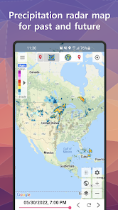
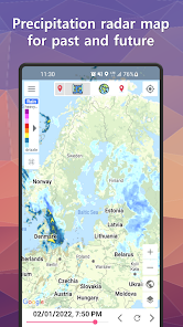
• Precipitation radar(Rain radar): Shows doppler radar images of rain, snow and storms in the past 24 hours and in the next 30 minutes prediction.
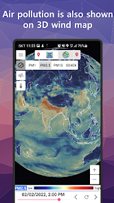
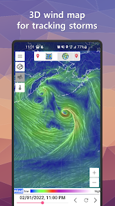
• 3D Wind Map: Shows routes of wind(storms like typhoon and hurricane), temperature and air pollution distribution(PM1, PM2.5, PM10, and So4ex particulates) up to maximum 48 hours(the past 24 hours and the next 24 hours prediction) based on the numerical model.
• Worldwide availability: Available in more than 90 countries(most of the Europe counturies, USA including Alaska and Hawaii, Canada, Puerto Rico, Australia, Asia, Africa and etc.) with over 1000 radar coverage with over 70 supported languages.
• Intuitive usage: You can explore the world including your location on the precipitation radr map and the 3D wind map. You can zoom in, pan, and search for the location wherever you want to check the rain, snow, wind(storms), temperature and air pollution distribution. You can compare various weather informations with the precipitation radr map and the 3D wind map on a location.
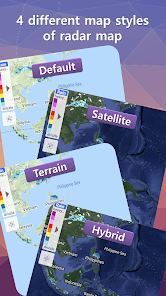
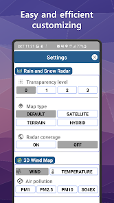
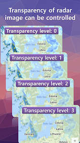
• Easy and efficient customizing: Enable to change radar image's transparency , map style(default, satellite, terrain, hybrid) and radar coverage indication directly on the radar map. Easily select the information like wind, temperature, and air pollution distribution(PM1, PM2.5, PM10, and So4ex particulates) showing on the 3D wind map. Also it can be done in the settings."
Key features
• Precipitation radar(Rain radar): Shows doppler radar images of rain, snow and storms in the past 24 hours and in the next 30 minutes prediction.
• 3D Wind Map: Shows routes of wind(storms like typhoon and hurricane), temperature and air pollution distribution(PM1, PM2.5, PM10, and So4ex particulates) up to maximum 48 hours(the past 24 hours and the next 24 hours prediction) based on the numerical model.
• Worldwide availability: Available in more than 90 countries(most of the Europe counturies, USA including Alaska and Hawaii, Canada, Puerto Rico, Australia, Asia, Africa and etc.) with over 1000 radar coverage with over 70 supported languages.
• Intuitive usage: You can explore the world including your location on the precipitation radr map and the 3D wind map. You can zoom in, pan, and search for the location wherever you want to check the rain, snow, wind(storms), temperature and air pollution distribution. You can compare various weather informations with the precipitation radr map and the 3D wind map on a location.
• Easy and efficient customizing: Enable to change radar image's transparency , map style(default, satellite, terrain, hybrid) and radar coverage indication directly on the radar map. Easily select the information like wind, temperature, and air pollution distribution(PM1, PM2.5, PM10, and So4ex particulates) showing on the 3D wind map. Also it can be done in the settings."
Ažurirano dana
Sigurnost počinje razumijevanjem na koji način programeri prikupljaju i dijele vaše podatke. Privatnost podataka i sigurnosne prakse se mogu razlikovati ovisno o korištenju, regiji i dobi. Programer je pružio ove informacije i može ih s vremenom ažurirati.


Šta ima novo
minor bugs fixed