PH Weather And Earthquakes
Sadržava oglaseKupovina unutar aplikacije
4,5star
3,38 hilj. recenzija
100 hilj.+
Preuzimanja

Svako
info
O aplikaciji
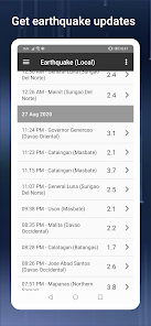
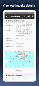
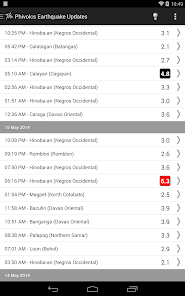
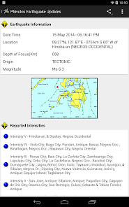
The PH Weather And Earthquakes app displays weather updates from PAGASA's (Philippine Atmosphereic Geophysical and Astronomical Services Administration) Project NOAH and earthquakes, tsunami and volcanic activity updates from PHIVOLCS (Philippine Institute of Volcanology and Seismology).
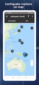
A worldwide earthquake list is also available based on data from U.S.G.S (U.S. Geological Survey).
This app was formerly known as PHIVOLCS Earthquake Alerts. The change of the app's name is important because the app now includes weather updates in the Philippines.
Other features include:
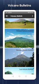
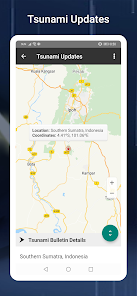
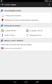
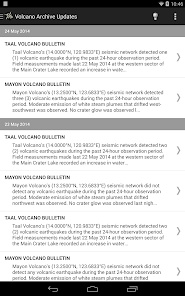
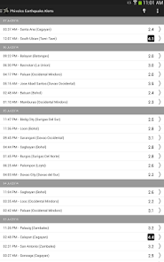
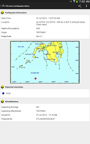
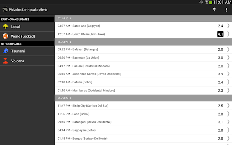
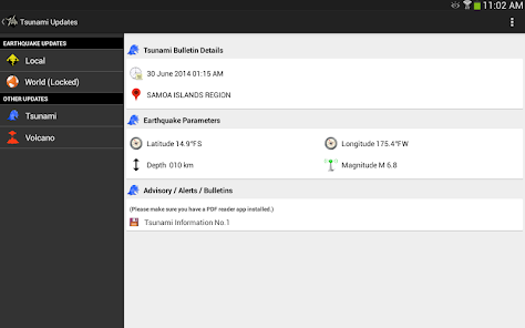
- Tsunami and volcanic activity updates.
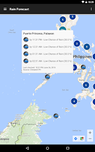
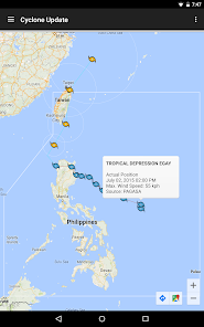
- Weather update features include 4 hour forecast, 4 day forecast and cyclone updates (typhoon, hurricane, cylcone).
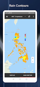
- Monitoring tools like doppler, sensors like stream gauge, rain gauge, tide level and weather station.
- Hazard maps for floods, landslides, storm surges.
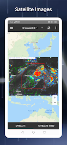
- MT Satellite images and videos
- Ovitrap (dengue) reports
- Boundaries map for provincial, municipal and barangay levels
- Critical facilities listing for schools, hospitals, police stations and fire stations nationwide.
- Emergency tools like flashlight, strobe light, siren and compass.
- Twitter updates on government agencies like PAGASA, PHIVOLCS, MMDA, DPWH, NDRRMC and Red Cross.
- Weekly and hourly weather forecasts based on custom searched cities.
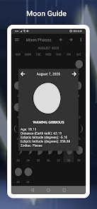
- Moon phase calendar including zodiac signs.
The Valley Fault System meanwhile has a visual map section and a download section with links from PHIVOLCS where users can use as reference on where fault lines are located. Both PHIVOLCS Fault Finder and LAVA (Local Active Volcano List) are also integrated.
If you have a feature you would like added, please visit the app's official Facebook page and leave a message.
Important Note: I am not affiliated with PHIVOLCS or PAGASA. The app just uses their data for most of its features.
A worldwide earthquake list is also available based on data from U.S.G.S (U.S. Geological Survey).
This app was formerly known as PHIVOLCS Earthquake Alerts. The change of the app's name is important because the app now includes weather updates in the Philippines.
Other features include:
- Tsunami and volcanic activity updates.
- Weather update features include 4 hour forecast, 4 day forecast and cyclone updates (typhoon, hurricane, cylcone).
- Monitoring tools like doppler, sensors like stream gauge, rain gauge, tide level and weather station.
- Hazard maps for floods, landslides, storm surges.
- MT Satellite images and videos
- Ovitrap (dengue) reports
- Boundaries map for provincial, municipal and barangay levels
- Critical facilities listing for schools, hospitals, police stations and fire stations nationwide.
- Emergency tools like flashlight, strobe light, siren and compass.
- Twitter updates on government agencies like PAGASA, PHIVOLCS, MMDA, DPWH, NDRRMC and Red Cross.
- Weekly and hourly weather forecasts based on custom searched cities.
- Moon phase calendar including zodiac signs.
The Valley Fault System meanwhile has a visual map section and a download section with links from PHIVOLCS where users can use as reference on where fault lines are located. Both PHIVOLCS Fault Finder and LAVA (Local Active Volcano List) are also integrated.
If you have a feature you would like added, please visit the app's official Facebook page and leave a message.
Important Note: I am not affiliated with PHIVOLCS or PAGASA. The app just uses their data for most of its features.
Ažurirano dana
Sigurnost počinje razumijevanjem na koji način programeri prikupljaju i dijele vaše podatke. Privatnost podataka i sigurnosne prakse se mogu razlikovati ovisno o korištenju, regiji i dobi. Programer je pružio ove informacije i može ih s vremenom ažurirati.

Ova aplikacija može dijeliti ove vrste podataka s trećim stranama
Lokacija, Informacije o aplikacijama i performanse i ID-ovi uređaja ili drugi ID-ovi

Podaci se ne prikupljaju
Saznajte više o načinu na koji programeri pružaju izjavu o prikupljanju

Podaci su šifrirani u prijenosu

Možete zatražiti da se podaci izbrišu
Ocjene i recenzije
4,4
3,19 hilj. recenzije
Šta ima novo
↑ ★ ★ ★ ★ ★ ↑
Like this app? Keep the developer inspired by giving a 5-star rating!
What's New?
- Fixed timeout issue for local quake, tsunami and volcano bulletin.
- Minor fixes.
Like this app? Keep the developer inspired by giving a 5-star rating!
What's New?
- Fixed timeout issue for local quake, tsunami and volcano bulletin.
- Minor fixes.