
오늘의물때 (조석예보, 물때표, 바다날씨, 바다낚시)
Contains ads
100K+
Downloads

Everyone
info


About this app
* The app name has been changed from Today's Gangtaegong to "Today's Tide".
Today's tide provides tide tables (tide forecasts) and sea weather information for up to 1,300 regions across the country. In addition, it provides fast and accurate meteorological/weather information, prevention of coastal safety accidents, and various marine weather information by providing sea water temperature, tide level observation information, sea splits, sea fishing points, real-time coastal CCTV footage, windy weather MAP, etc. This is Korea’s TOP marine information application.
¿If you want to check the tide and weather for sea fishing™
¿ If you are a person who does not know fishing equipment / sea fishing points and is just making a fuss ™
¿ If you enjoy marine leisure activities such as surfing, yachting, boating, and scuba diving ™
¿ If you want to take beautiful sunrise/sunset photos while traveling to the island or sea ™
¿ If you are planning a mud flat experience with your family ™
The nation’s largest marine information and sea weather service!
Introducing “Today’s Tide.”
★ 5 major services!
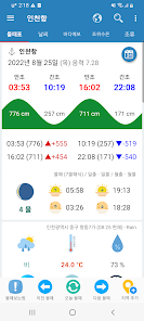
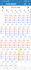
1. Tide time table: We provide information on tide times (tide forecast) and sunrise, sunset, moonrise, and moonset information for over 1,300 regions across the country. We also provide weather, temperature, wind direction, wind speed, pressure, and location information for the area. [Low tide / high tide view] provides two functions, simple view and graph view, to make viewing tide times simpler and easier for beginners.
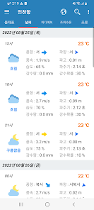
2. Local weather: Information on temperature, precipitation, humidity, wind direction, wind speed, wave height, wave direction, and wave period is provided according to the area where tide spots were observed.
3. Sea weather: We provide services based on the west coast, south coast, east coast, and Jeju Island, including wave height, wind direction, and wind speed throughout the domestic seas, from offshore to distant seas, focusing on the 8 provinces of the country.
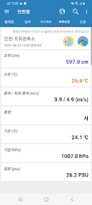
4. Sea water temperature and tide level observation: Provides marine weather observation information such as tide level, sea water temperature, wind direction, wind speed, temperature, barometric pressure, and salinity in 80 major observatory areas. Additionally, we provide water temperature information for the area closest to the tide zone through 160 water temperature observation stations across the country. (last 3 days)
5. Current strength (excluding the East Sea): Provides a graph of the current strength (current speed) for the next 30 days based on the current date.
★ Today's tide additional features and services!
1. Tide calendar and monthly tide table provided: We provide a tide table calendar and monthly tide tables so that you can view them for the last 30 days or by month.
2. Fast and diverse area/map search: You can quickly and easily find an area by searching with the initial consonant, and simply find the area you want through the map.
3. Tide area favorites: Frequently viewed areas can be managed through [Favorites], and a save/delete function is provided.
4. Sea fishing points: We service the locations of 2,000 coastal rock and breakwater fishing points and 300 boat fishing points nationwide, along with information on appropriate tide times, depth, bottom quality, target fish species, fishing gear, and bait.
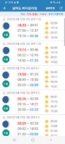
5. Nationwide sea split: We provide information on ocean splits in 14 locations across the country (Silmido, Seonjaedo, Soyado, Ungdo, Jebudo, Muchangpo, Haseom, Hwado, Jindo, Haenamdaeseom, Udo, Somaemuldo, Dongseom, and Seogeondo).
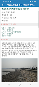
6. National weather warning: Provides coastal weather information, including weather warnings and breaking news provided by the Korea Meteorological Administration.
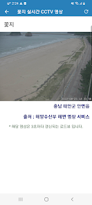
7. Real-time coastal video: We provide real-time coastal CCTV video from major ports and beaches across the country.
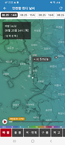
8. Windy Weather (Windy): Check information on wind (wind direction, wind speed), wave height (wave direction, wave period, waves), temperature, pressure, rain, clouds, fine dust, sea water temperature, etc. in real time across the country on the Windy map. You can do it.
9. Korea Meteorological Administration web service: Provides detailed weather information such as Korea Meteorological Administration national/ocean weather, radar/satellite weather images, Korea Meteorological Administration fog/water temperature images, yellow dust/typhoon/earthquake information, etc.
10. Wave height, precipitation, and rain cloud forecast information from the IMOC nationwide Japan meteorological information map are included.
11. We provide tide information for 2024, including past tide information (18-23) for 1,300 regions across the country.
12. KakaoTalk sharing function: For all regions provided by Today's Tide, you can use the KakaoTalk sharing function to share today's date or a specific date's tide time with friends or acquaintances.
## Precautions and disclaimers for use
- The data provided by Today's Tide is not suitable for purposes such as navigation or ship departure. Additionally, we are not responsible for any direct or indirect damages, including accidents or disadvantages, incurred by users by using the service. It is entirely up to the user to decide whether to use the information provided.
※ Information provider
## OPENWEATHERMAP :: Real-time local weather information
## WINDY.com - WEATHER MAP API / Point Forecast API
## Public data portal (Korea Meteorological Administration) - special weather reports, mid-term forecasts, and domestic national weather page
## National Oceanographic Research Institute - Badanuri Marine Information Service
## National Oceanographic Research Institute - KOMC / Open Sea / Safe Sea, etc.
## National Oceanic and Atmospheric Administration (NOAA)
Today's tide provides tide tables (tide forecasts) and sea weather information for up to 1,300 regions across the country. In addition, it provides fast and accurate meteorological/weather information, prevention of coastal safety accidents, and various marine weather information by providing sea water temperature, tide level observation information, sea splits, sea fishing points, real-time coastal CCTV footage, windy weather MAP, etc. This is Korea’s TOP marine information application.
¿If you want to check the tide and weather for sea fishing™
¿ If you are a person who does not know fishing equipment / sea fishing points and is just making a fuss ™
¿ If you enjoy marine leisure activities such as surfing, yachting, boating, and scuba diving ™
¿ If you want to take beautiful sunrise/sunset photos while traveling to the island or sea ™
¿ If you are planning a mud flat experience with your family ™
The nation’s largest marine information and sea weather service!
Introducing “Today’s Tide.”
★ 5 major services!
1. Tide time table: We provide information on tide times (tide forecast) and sunrise, sunset, moonrise, and moonset information for over 1,300 regions across the country. We also provide weather, temperature, wind direction, wind speed, pressure, and location information for the area. [Low tide / high tide view] provides two functions, simple view and graph view, to make viewing tide times simpler and easier for beginners.
2. Local weather: Information on temperature, precipitation, humidity, wind direction, wind speed, wave height, wave direction, and wave period is provided according to the area where tide spots were observed.
3. Sea weather: We provide services based on the west coast, south coast, east coast, and Jeju Island, including wave height, wind direction, and wind speed throughout the domestic seas, from offshore to distant seas, focusing on the 8 provinces of the country.
4. Sea water temperature and tide level observation: Provides marine weather observation information such as tide level, sea water temperature, wind direction, wind speed, temperature, barometric pressure, and salinity in 80 major observatory areas. Additionally, we provide water temperature information for the area closest to the tide zone through 160 water temperature observation stations across the country. (last 3 days)
5. Current strength (excluding the East Sea): Provides a graph of the current strength (current speed) for the next 30 days based on the current date.
★ Today's tide additional features and services!
1. Tide calendar and monthly tide table provided: We provide a tide table calendar and monthly tide tables so that you can view them for the last 30 days or by month.
2. Fast and diverse area/map search: You can quickly and easily find an area by searching with the initial consonant, and simply find the area you want through the map.
3. Tide area favorites: Frequently viewed areas can be managed through [Favorites], and a save/delete function is provided.
4. Sea fishing points: We service the locations of 2,000 coastal rock and breakwater fishing points and 300 boat fishing points nationwide, along with information on appropriate tide times, depth, bottom quality, target fish species, fishing gear, and bait.
5. Nationwide sea split: We provide information on ocean splits in 14 locations across the country (Silmido, Seonjaedo, Soyado, Ungdo, Jebudo, Muchangpo, Haseom, Hwado, Jindo, Haenamdaeseom, Udo, Somaemuldo, Dongseom, and Seogeondo).
6. National weather warning: Provides coastal weather information, including weather warnings and breaking news provided by the Korea Meteorological Administration.
7. Real-time coastal video: We provide real-time coastal CCTV video from major ports and beaches across the country.
8. Windy Weather (Windy): Check information on wind (wind direction, wind speed), wave height (wave direction, wave period, waves), temperature, pressure, rain, clouds, fine dust, sea water temperature, etc. in real time across the country on the Windy map. You can do it.
9. Korea Meteorological Administration web service: Provides detailed weather information such as Korea Meteorological Administration national/ocean weather, radar/satellite weather images, Korea Meteorological Administration fog/water temperature images, yellow dust/typhoon/earthquake information, etc.
10. Wave height, precipitation, and rain cloud forecast information from the IMOC nationwide Japan meteorological information map are included.
11. We provide tide information for 2024, including past tide information (18-23) for 1,300 regions across the country.
12. KakaoTalk sharing function: For all regions provided by Today's Tide, you can use the KakaoTalk sharing function to share today's date or a specific date's tide time with friends or acquaintances.
## Precautions and disclaimers for use
- The data provided by Today's Tide is not suitable for purposes such as navigation or ship departure. Additionally, we are not responsible for any direct or indirect damages, including accidents or disadvantages, incurred by users by using the service. It is entirely up to the user to decide whether to use the information provided.
※ Information provider
## OPENWEATHERMAP :: Real-time local weather information
## WINDY.com - WEATHER MAP API / Point Forecast API
## Public data portal (Korea Meteorological Administration) - special weather reports, mid-term forecasts, and domestic national weather page
## National Oceanographic Research Institute - Badanuri Marine Information Service
## National Oceanographic Research Institute - KOMC / Open Sea / Safe Sea, etc.
## National Oceanic and Atmospheric Administration (NOAA)
Updated on
Safety starts with understanding how developers collect and share your data. Data privacy and security practices may vary based on your use, region, and age. The developer provided this information and may update it over time.

No data shared with third parties
Learn more about how developers declare sharing

No data collected
Learn more about how developers declare collection

Data is encrypted in transit

Data can’t be deleted