
LandXML(TIN)ビューワー
10+
Downloads

Everyone
info
About this app
It is used as a terrain data model in public works in the field of civil engineering and construction.
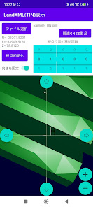
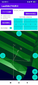
This is a viewer app that supports LandXML format (TIN surface) files.
You can read the terrain model saved in LandXML format and display it on the screen, display the data from a free viewpoint, and check the 3D coordinates of the point being displayed.
Instruction manual link for this app
https://drive.google.com/file/d/1e4kmuoj7qBXRVUY32fyD1o3Du8Q31Jet/view?usp=sharing
For compatible GNSS observation systems, please contact us from the following site.
https://www.qzss4survey.com/
Updated on
Safety starts with understanding how developers collect and share your data. Data privacy and security practices may vary based on your use, region and age The developer provided this information and may update it over time.

No data shared with third parties
Learn more about how developers declare sharing

No data collected
Learn more about how developers declare collection
What's new
デバイスの位置情報=現在位置として、3Dモデル上の位置を表示する機能を追加しました。
App support
phone
Phone number
+815058062083


