
Memory-Map
3.9star
4.49K reviews
100K+
Downloads

Everyone
info


About this app
The Memory-Map app turns your phone or tablet into a full-featured Outdoor GPS or Marine Chart Plotter, and allows you to navigate with Topo maps, Hema 4WD maps or Marine charts, even without a wireless internet signal.
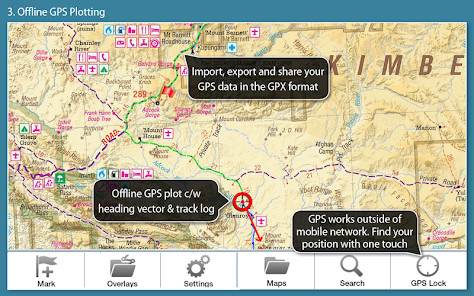
Maps are downloaded on-the-fly and can be pre-loaded so that they can be used offline. Once the app and maps are loaded to the phone or tablet, cellular network coverage or internet connection is not required for real time GPS navigation.
The Memory-Map app can be used as a standalone GPS navigator, but it can also be used in conjunction with the Windows PC app (free download) for planning, printing and loading up maps, waypoints and routes to the phone/tablet.
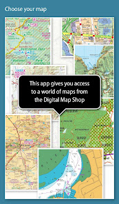
Memory-Map includes access to 1:250,000 scale topographic maps and many other maps around the world. More detailed maps are available for download and purchase with a free try-before-you-buy, time-limited demo option. Available maps include Ordnance Survey, Hema, USGS quads, NOAA, British Admiralty, and DeLorme. Maps can be used on your PC as well as your phone and tablet. The Cloud Sync feature allows you to keep the overlay data consistent on all your devices.
Features include:
Access a vast range of Worldwide maps and charts.
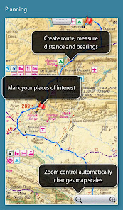
Create and edit marks and routes.
Import and export marks, routes and tracks in the open GPX format
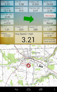
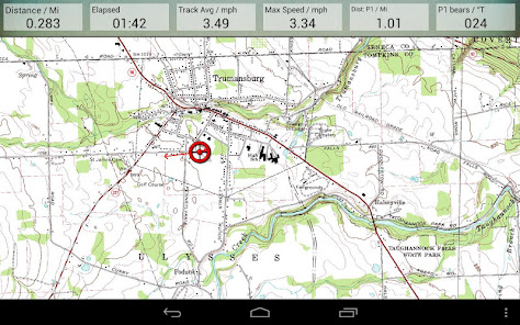
Display; Position, Course, Speed, Heading, Altitude and averages
Position coordinates include Lat/Long, UTM and GB Grid
Units displayed in Statute, Nautical or Metric
Support for GPS, Compass and Barometer sensors, where available.
Placename index, can be used offline.
Moving map, lock GPS position and automatically scroll the map
Records breadcrumb trail / tracklogs.
Share position marks or tracklogs as GPX files
Proximity Alarm
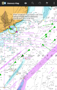
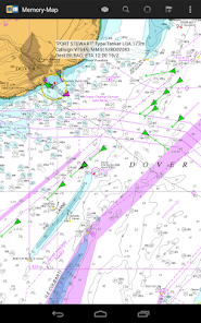
Full marine instrumentation features, with AIS, DSC and Anchor alarm
NMEA data interface via WiFi or Bluetooth
AIS collision alarm, with adjustable thresholds for Class A and Class B targets
Display Alarm notifications and Nav data on Android Wear watch
Barometer and relative altitude
Maps are downloaded on-the-fly and can be pre-loaded so that they can be used offline. Once the app and maps are loaded to the phone or tablet, cellular network coverage or internet connection is not required for real time GPS navigation.
The Memory-Map app can be used as a standalone GPS navigator, but it can also be used in conjunction with the Windows PC app (free download) for planning, printing and loading up maps, waypoints and routes to the phone/tablet.
Memory-Map includes access to 1:250,000 scale topographic maps and many other maps around the world. More detailed maps are available for download and purchase with a free try-before-you-buy, time-limited demo option. Available maps include Ordnance Survey, Hema, USGS quads, NOAA, British Admiralty, and DeLorme. Maps can be used on your PC as well as your phone and tablet. The Cloud Sync feature allows you to keep the overlay data consistent on all your devices.
Features include:
Access a vast range of Worldwide maps and charts.
Create and edit marks and routes.
Import and export marks, routes and tracks in the open GPX format
Display; Position, Course, Speed, Heading, Altitude and averages
Position coordinates include Lat/Long, UTM and GB Grid
Units displayed in Statute, Nautical or Metric
Support for GPS, Compass and Barometer sensors, where available.
Placename index, can be used offline.
Moving map, lock GPS position and automatically scroll the map
Records breadcrumb trail / tracklogs.
Share position marks or tracklogs as GPX files
Proximity Alarm
Full marine instrumentation features, with AIS, DSC and Anchor alarm
NMEA data interface via WiFi or Bluetooth
AIS collision alarm, with adjustable thresholds for Class A and Class B targets
Display Alarm notifications and Nav data on Android Wear watch
Barometer and relative altitude
Updated on
Safety starts with understanding how developers collect and share your data. Data privacy and security practices may vary based on your use, region and age The developer provided this information and may update it over time.

No data shared with third parties
Learn more about how developers declare sharing

This app may collect these data types
Location and Personal info

Data is encrypted in transit

You can request that data be deleted
Ratings and reviews
3.7
3.41K reviews

Lawrence Pearce
- Flag inappropriate
26 April 2024
Excellent tool. No problems encountered. Makes hiking a doddle. 73 years old and still going strong, and not moaning !!! Edit 2016: I've used this on a Blackberry and two androids latest is Motorola 3G and it works fine, I'm using MM 2014 UK HD. If you read up and follow instructions it works fine. A good web site to help is lonewalker UK, great site and great help on MM app. 81 now and still using MM app, its been a great friend for me.

A Google user
- Flag inappropriate
18 July 2021
I use the app all the time. Climbing and cycling. If you like real maps, this is for you. There are issues though, for instance the 'stay on' override doesn't work on all phones. Certainly not on the S7 active I use at the moment. Also, on a bike you need a phone that you can turn on just by pressing a button, as the maps go haywire if the screen is wet, and you therefore can't touch it, or leave it on any longer than needed. Apart from basic viewing, operation is not at all intuitive.

Robert Farrands
- Flag inappropriate
7 August 2022
Memory Map is the best of a bad bunch of apps for navigating. You can pre load maps into phone memory. It's expensive, yearly subscriptions req'd for current maps and cloud syncing. But I do find it easy to plot routes though. Good for marine navigation with clear charts, easy plotting and an anchor alarm. It needs an "always points North" option and far better analysis of activities and the option to determine the type of activity: running, MTBing etc.. It hasn't changed much over 20 years.
1 person found this review helpful
Memory-Map, Inc.
10 April 2014
Robert, The map licenses do not expire. In the Digital Map Shop listing, tap Map Types, and you can select to download older edition maps or charts.
What's new
Tap a track to select/edit
Find time, speed and altitude at any point on a track
Split/Join tracks
Split/Join routes
Added line styles (dash, dot, etc) for tracks and routes
Scoped Storage for Data Layout files and GPX data.
Display maps storage by folder
Delete all maps by type or folder
Find time, speed and altitude at any point on a track
Split/Join tracks
Split/Join routes
Added line styles (dash, dot, etc) for tracks and routes
Scoped Storage for Data Layout files and GPX data.
Display maps storage by folder
Delete all maps by type or folder
