
Boracay offline map
10+
Downloads

Everyone
info
About this app
Offline map of Boracay resort island. Download the app before you go and avoid being hit with expensive roaming charges. The map runs completely on your device; map display with pan and infinite zoom, routing, searching, everything. It does not use your data connection at all. Switch your phone function off if you want to.
No ads. All features fully functional, no extra downloads, no "in app purchases" required.
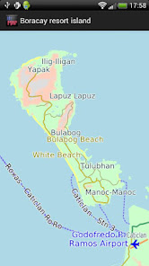
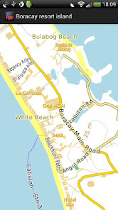
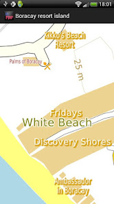
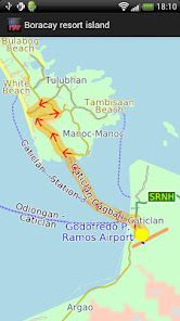
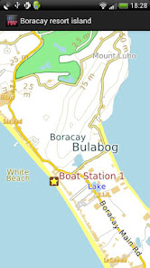
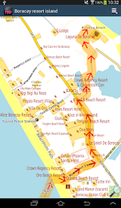
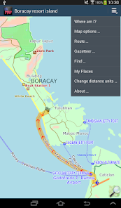
The map is based on OpenStreetMap data, http://www.openstreetmap.org. It includes well over 200 hotels and guest houses, probably nearly all of them, all the roads, all the beaches and many but not all of the foot paths and tracks. The nearest airport and ferry terminals at Caticlan are also shown.
You can help improve coverage by becoming an OpenStreetMap contributor. We will publish app updates with new information.
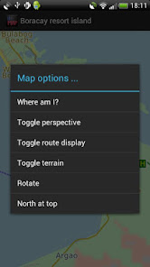
Terrain is shown on the map, and can be turned on or off.
The app includes a search function and a gazetteer of commonly needed items like hotels and eating places.
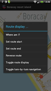
Turn-by-turn navigation is available on devices with GPS. If you don't have a GPS device, you can still show a route between two locations.
Navigation will show you an indicative route and can be configured for car, bicycle or foot. The developers cannot guarantee correctness. For example, it does not show turn restrictions - places where it is illegal to turn. Some rural roads may be suitable for four-wheel drive vehicles only and/or for people familiar with the area and terrain. Use with care and above all look out for and obey road signs. "OpenStreetMap is not a complete or accurate map of the world and should not be used in such a manner that deficiencies, omissions, inaccuracies or errors could result in death, loss or injury.", http://wiki.openstreetmap.org/wiki/Disclaimer.
Like most small developers, we cannot test a wide variety of phones and tablets. If you have trouble running the application, do email us and we will try to help.
No ads. All features fully functional, no extra downloads, no "in app purchases" required.
The map is based on OpenStreetMap data, http://www.openstreetmap.org. It includes well over 200 hotels and guest houses, probably nearly all of them, all the roads, all the beaches and many but not all of the foot paths and tracks. The nearest airport and ferry terminals at Caticlan are also shown.
You can help improve coverage by becoming an OpenStreetMap contributor. We will publish app updates with new information.
Terrain is shown on the map, and can be turned on or off.
The app includes a search function and a gazetteer of commonly needed items like hotels and eating places.
Turn-by-turn navigation is available on devices with GPS. If you don't have a GPS device, you can still show a route between two locations.
Navigation will show you an indicative route and can be configured for car, bicycle or foot. The developers cannot guarantee correctness. For example, it does not show turn restrictions - places where it is illegal to turn. Some rural roads may be suitable for four-wheel drive vehicles only and/or for people familiar with the area and terrain. Use with care and above all look out for and obey road signs. "OpenStreetMap is not a complete or accurate map of the world and should not be used in such a manner that deficiencies, omissions, inaccuracies or errors could result in death, loss or injury.", http://wiki.openstreetmap.org/wiki/Disclaimer.
Like most small developers, we cannot test a wide variety of phones and tablets. If you have trouble running the application, do email us and we will try to help.
Updated on
Safety starts with understanding how developers collect and share your data. Data privacy and security practices may vary based on your use, region and age The developer provided this information and may update it over time.

No data shared with third parties
Learn more about how developers declare sharing

This app may collect these data types
App activity, App info and performance and Device or other IDs

Data is encrypted in transit

Data can’t be deleted
What's new
- Latest OpenStreetMap data
- Android 10 compatibility
- Removed "Advanced Find" menu item to simplify the app, contact us via our Developer Email on the Google Play Store if you want this back.
- Added Crashlytics. If the app crashes, information about the crash is automatically sent to us. No personal data is sent. Your location is not sent.
- Ski runs and ski lifts now show where applicable
- Reservoir dams now show
- Some map style tweaks, e.g service roads thinner to contrast them better.


