
Chuyển Tọa Độ VN2000
100K+
Downloads

Everyone
info


About this app
Purpose of application:
- Find a plot of land on the Google Maps map when drawing the location coordinates (in the VN2000 system).
- Used in the field of measurement: to find the landmark, the point location to make landmark, calculate the reference coordinates.
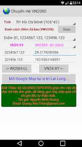
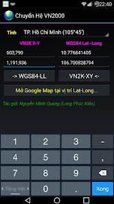
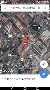
Application for converting 2-way XY coordinates in VN2000 to Lat-Long WGS84.
- The XY coordinate system in the VN2000 system is used in regular drawings such as Dust Book, Land Certificate, Technical Drawings.
Lat-Long coordinates are used as the international standard for Google Maps. So to locate a point in the Red Book drawing on Google Maps satellite imagery, we need to convert it to the Latitude Longitude WGS84 and send it to the Google Maps application.
* The program is completely free, do not insert ads.
- Find a plot of land on the Google Maps map when drawing the location coordinates (in the VN2000 system).
- Used in the field of measurement: to find the landmark, the point location to make landmark, calculate the reference coordinates.
Application for converting 2-way XY coordinates in VN2000 to Lat-Long WGS84.
- The XY coordinate system in the VN2000 system is used in regular drawings such as Dust Book, Land Certificate, Technical Drawings.
Lat-Long coordinates are used as the international standard for Google Maps. So to locate a point in the Red Book drawing on Google Maps satellite imagery, we need to convert it to the Latitude Longitude WGS84 and send it to the Google Maps application.
* The program is completely free, do not insert ads.
Updated on
Safety starts with understanding how developers collect and share your data. Data privacy and security practices may vary based on your use, region, and age. The developer provided this information and may update it over time.

No data shared with third parties
Learn more about how developers declare sharing

No data collected
Learn more about how developers declare collection
What's new
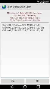
- Hỗ trợ SOẠN và LƯU danh sách điểm VN2000, phục vụ cho các anh em đo đạc
- Thay đổi phông nền, màu chữ cho phù hợp khi làm việc ngoài trời.
- Hỗ trợ cả 3 dạng Long-Lat, bao gồm:
+ Độ (dd.dddd)
+ Độ Phút (dd pp.pppp)
+ Độ Phút Giây (dd pp gg.gggg)
- Thay đổi phông nền, màu chữ cho phù hợp khi làm việc ngoài trời.
- Hỗ trợ cả 3 dạng Long-Lat, bao gồm:
+ Độ (dd.dddd)
+ Độ Phút (dd pp.pppp)
+ Độ Phút Giây (dd pp gg.gggg)


