
INGV Terremoti
100K+
Downloads

Everyone
info
About this app
This is the official application of the National Institute of Geophysics and Volcanology (INGV) which shows data relating to the most recent earthquakes that occur in Italy and, limited to the strongest events, in the rest of the world.
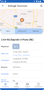
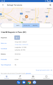
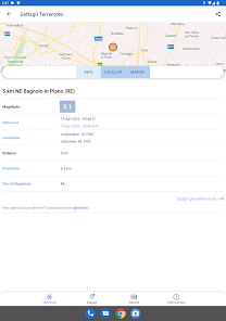
The parameters (origin time, epicentral coordinates, depth and magnitude) of the earthquake locations are available thanks to the INGV Seismic Surveillance Service, active 24 hours a day, 7 days a week.
Parameters are subject to change as new data becomes available.
AUTOMATIC LOCATIONS
The signals, i.e. the seismograms, of the almost 400 stations of the National Seismic Network and other networks that contribute to it arrive in real time in the Seismic Surveillance Room of the INGV in Rome. The signals are all digital and managed by dedicated software. When a certain minimum number of stations registers an earthquake, the computer systems used associate the signals with each other and try to calculate the hypocentral location and determine the magnitude. During this operation, which can take 1 or 2 minutes, the goodness of the determination with quantitative parameters is also evaluated.
If these parameters show sufficient quality and for events with a magnitude greater than 3, INGV communicates the automatic preliminary data through the app in an orange box above the list of earthquakes, signaling that this information is not verified with the indication [PROVISIONAL ESTIMATE]. In this case, the magnitude is provided with a range of values and the area is indicated with the zone or province within which the epicenter falls.
Meanwhile, the seismologists, who work 24-hour shifts, begin reviewing the location and magnitude: they analyze the individual signals, verify that the software has worked correctly in identifying the arrival of P waves and S waves and in calculating the maximum amplitudes. At the end of the review, the hypocentral position (latitude, longitude, depth) is recalculated and the magnitude re-estimated. Depending on the magnitude of the earthquake – and therefore the number of seismic stations recording it – and the geological complexities of the affected region, it can take up to 30 minutes to complete the review.
Within the app, the revised location data is entered in the list of seismic events and at the same time the corresponding orange box of the provisional estimate disappears.
HOURS
In the Last earthquakes section, the times of seismic events are **no longer** expressed using the reference time UTC (Coordinated Universal Time) but the time in which the phone is configured.
FEATURES
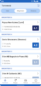
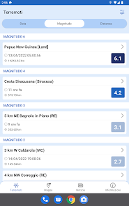
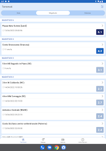
The App allows you to view the latest earthquakes that occurred in the previous 3 days.
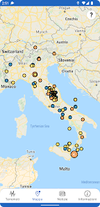
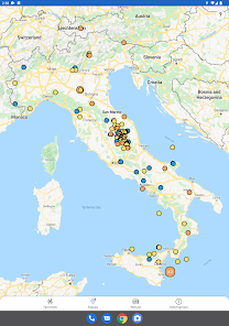
The App also allows you to view the Italian seismic activity from 2005 onwards, through the Earthquake Research section. You can search for earthquakes:
- of the last 20 days or in a selected time interval.
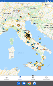
- all over the world, all over Italy, closer to the current position, around a Municipality, and finally entering specific coordinate values.
- with magnitude values within a selected range.
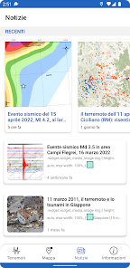
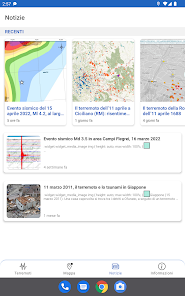
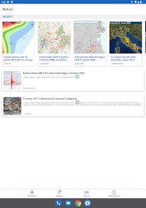
Particular attention has been paid to scientific information regarding earthquakes; there are in fact sections linked to the INGVterremoti blog ingvterremoti.com.
The parameters (origin time, epicentral coordinates, depth and magnitude) of the earthquake locations are available thanks to the INGV Seismic Surveillance Service, active 24 hours a day, 7 days a week.
Parameters are subject to change as new data becomes available.
AUTOMATIC LOCATIONS
The signals, i.e. the seismograms, of the almost 400 stations of the National Seismic Network and other networks that contribute to it arrive in real time in the Seismic Surveillance Room of the INGV in Rome. The signals are all digital and managed by dedicated software. When a certain minimum number of stations registers an earthquake, the computer systems used associate the signals with each other and try to calculate the hypocentral location and determine the magnitude. During this operation, which can take 1 or 2 minutes, the goodness of the determination with quantitative parameters is also evaluated.
If these parameters show sufficient quality and for events with a magnitude greater than 3, INGV communicates the automatic preliminary data through the app in an orange box above the list of earthquakes, signaling that this information is not verified with the indication [PROVISIONAL ESTIMATE]. In this case, the magnitude is provided with a range of values and the area is indicated with the zone or province within which the epicenter falls.
Meanwhile, the seismologists, who work 24-hour shifts, begin reviewing the location and magnitude: they analyze the individual signals, verify that the software has worked correctly in identifying the arrival of P waves and S waves and in calculating the maximum amplitudes. At the end of the review, the hypocentral position (latitude, longitude, depth) is recalculated and the magnitude re-estimated. Depending on the magnitude of the earthquake – and therefore the number of seismic stations recording it – and the geological complexities of the affected region, it can take up to 30 minutes to complete the review.
Within the app, the revised location data is entered in the list of seismic events and at the same time the corresponding orange box of the provisional estimate disappears.
HOURS
In the Last earthquakes section, the times of seismic events are **no longer** expressed using the reference time UTC (Coordinated Universal Time) but the time in which the phone is configured.
FEATURES
The App allows you to view the latest earthquakes that occurred in the previous 3 days.
The App also allows you to view the Italian seismic activity from 2005 onwards, through the Earthquake Research section. You can search for earthquakes:
- of the last 20 days or in a selected time interval.
- all over the world, all over Italy, closer to the current position, around a Municipality, and finally entering specific coordinate values.
- with magnitude values within a selected range.
Particular attention has been paid to scientific information regarding earthquakes; there are in fact sections linked to the INGVterremoti blog ingvterremoti.com.
Updated on
Safety starts with understanding how developers collect and share your data. Data privacy and security practices may vary based on your use, region, and age. The developer provided this information and may update it over time.

No data shared with third parties
Learn more about how developers declare sharing

No data collected
Learn more about how developers declare collection

Data isn’t encrypted
Data can’t be deleted