
富士宮市防災マップ
1K+
Downloads

Everyone
info


About this app
■ Functional map
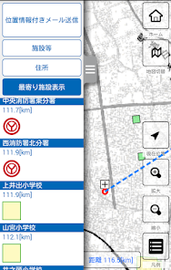
・ We use a map that displays disaster prevention related facilities visually in an easy-to-understand manner using pictograms.
You can intuitively grasp the layout of disaster prevention related facilities.
-When online, you can use the distribution-type map service, and when you are offline, you can use the map built into the app and the map that is temporarily saved on your smartphone when you are online.
■ Sending a message with location information
・ You can send an e-mail containing information indicating your current location.
The content of the email can be selected from the template, such as "It is safe", and it can be changed and sent.
■ Abundant search
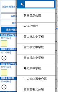
・ Facility search
The facility selected from the facility list is displayed on the map.
In the list, by entering a part of the facility name, the selection target is narrowed down and displayed.
It is also possible to narrow down the selection target by the type of facility.
・ Address search
Displays a map of the area selected from the list of addresses in the city.
・ Peripheral search
The facility list is displayed in the order of the current position (when using GPS) or the distance from the center of the displayed map.
■ Guidance display to the destination
・ From the current position (when using GPS) to the facility selected as the target, connect with a line along with the distance display and guide.
・ When online, you can start the map app and search the route from your current location to your target.
=================
[Provider information]
Provider: Fujinomiya City, Shizuoka Prefecture
Product development: Chuo Geomatics Co., Ltd.
Map information: Fujinomiya City, Shizuoka Prefecture, Chuo Geomatics Co., Ltd.
[Introduction]
・ The information on the "Fujinomiya City Disaster Prevention Map" posted in this app is based on the information as of March 2020.
・ The copyright of the information provided in this application belongs to Fujinomiya City, Shizuoka Prefecture. However, this excludes those by known and existing copyright holders.
・ Please note that we are not responsible for any troubles that may occur when using this application product.
・ For online maps, we use Google Maps and Geographical Survey Institute Map (http://maps.gsi.go.jp/) of the Geographical Survey Institute.
[Contact for inquiries regarding disaster prevention maps and disaster prevention information]
Crisis Management Section, Crisis Management Bureau, Fujinomiya City, Shizuoka Prefecture
TEL: 0544-22-1319
・ We use a map that displays disaster prevention related facilities visually in an easy-to-understand manner using pictograms.
You can intuitively grasp the layout of disaster prevention related facilities.
-When online, you can use the distribution-type map service, and when you are offline, you can use the map built into the app and the map that is temporarily saved on your smartphone when you are online.
■ Sending a message with location information
・ You can send an e-mail containing information indicating your current location.
The content of the email can be selected from the template, such as "It is safe", and it can be changed and sent.
■ Abundant search
・ Facility search
The facility selected from the facility list is displayed on the map.
In the list, by entering a part of the facility name, the selection target is narrowed down and displayed.
It is also possible to narrow down the selection target by the type of facility.
・ Address search
Displays a map of the area selected from the list of addresses in the city.
・ Peripheral search
The facility list is displayed in the order of the current position (when using GPS) or the distance from the center of the displayed map.
■ Guidance display to the destination
・ From the current position (when using GPS) to the facility selected as the target, connect with a line along with the distance display and guide.
・ When online, you can start the map app and search the route from your current location to your target.
=================
[Provider information]
Provider: Fujinomiya City, Shizuoka Prefecture
Product development: Chuo Geomatics Co., Ltd.
Map information: Fujinomiya City, Shizuoka Prefecture, Chuo Geomatics Co., Ltd.
[Introduction]
・ The information on the "Fujinomiya City Disaster Prevention Map" posted in this app is based on the information as of March 2020.
・ The copyright of the information provided in this application belongs to Fujinomiya City, Shizuoka Prefecture. However, this excludes those by known and existing copyright holders.
・ Please note that we are not responsible for any troubles that may occur when using this application product.
・ For online maps, we use Google Maps and Geographical Survey Institute Map (http://maps.gsi.go.jp/) of the Geographical Survey Institute.
[Contact for inquiries regarding disaster prevention maps and disaster prevention information]
Crisis Management Section, Crisis Management Bureau, Fujinomiya City, Shizuoka Prefecture
TEL: 0544-22-1319
Updated on
Safety starts with understanding how developers collect and share your data. Data privacy and security practices may vary based on your use, region, and age. The developer provided this information and may update it over time.

No data shared with third parties
Learn more about how developers declare sharing

No data collected
Learn more about how developers declare collection
What's new
防災情報(PDF)を更新しました。
土砂災害警戒区域を更新しました。
土砂災害警戒区域を更新しました。


